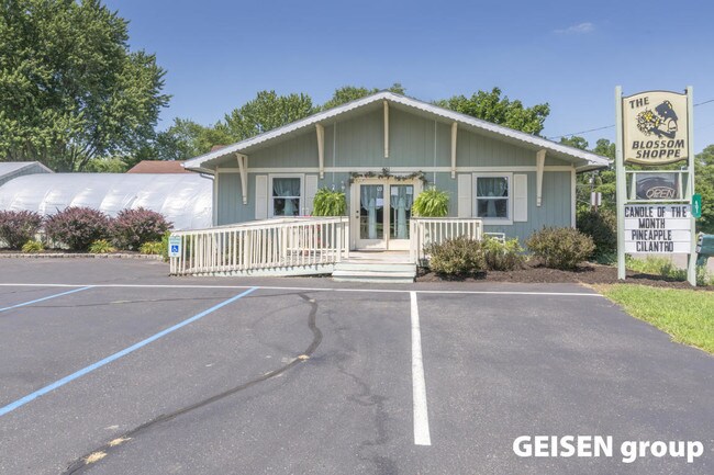
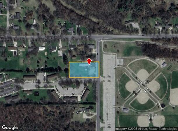
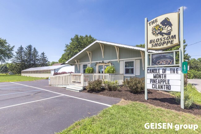
Property Record
401 N Demorest St, Belding, MI 48809
NEARBY LISTINGS FOR SALE OR LEASE
-
-
View all Belding listings for sale on LoopNet.com
Property Detail
401 N Demorest St
401-040-000-345-00
CITY OF BELDING COM N 1/4 PT SEC 10 T8N R8W, TH S 229.5 FT TO POB; TH W 296.5 FT, S 150.5 FT, E 296.5 FT, N 150.5 FT TO
Commercialnec
Ionia
X
Michigan
26067C0026D
1.02 AC
2024
Ionia County
2025
West Michigan
030300
Grand Rapids-Wyoming-Kentwood, MI
924 SF
DEMOGRAPHICS near 401 N Demorest St
1 mile
3 mile
5 mile
2024 Total Population
3,893
7,971
14,271
2029 Population
3,977
8,171
14,735
Pop Growth 2024-2029
+ 2.16%
+ 2.51%
+ 3.25%
Average Age
39
40
41
2024 Total Households
1,575
3,076
5,508
HH Growth 2024-2029
+ 1.90%
+ 2.31%
+ 3.12%
Median Household Inc
$46,546
$53,541
$56,027
Avg Household Size
2.40
2.50
2.50
2024 Avg HH Vehicles
2.00
2.00
2.00
Median Home Value
$124,506
$137,537
$153,980
Median Year Built
1960
1959
1968
Nearby Places
Map Layers
Map Styles
 Street
 Aerial
Transit
 Traffic
 Biking
Places
Listings with unknown addresses are not visible on the map
- Restaurants
- Banks
- Shops
- Fitness
- Groceries
PUBLIC TRANSPORTATION
AIRPORT
Gerald R Ford International
Drive
Walk
Distance
Gerald R Ford International
52 min
34.9 mi
Freight Ports
Port of Toledo
Drive
Walk
Distance
Port of Toledo
219 min
181.2 mi
Nearby Properties
Address
Land Use
TOTAL SIZE
Lot Size
Zoning
Address
Land Use
TOTAL SIZE
Lot Size
Zoning
Address
Land Use
TOTAL SIZE
Lot Size
Zoning
168,870 SF
11.73 AC
Address
Land Use
TOTAL SIZE
Lot Size
Zoning
51.80 AC
I-1
Address
Land Use
TOTAL SIZE
Lot Size
Zoning
42,745 SF
3.05 AC
RM-1
Address
Land Use
TOTAL SIZE
Lot Size
Zoning
1,536 SF
4.11 AC
RM-1
Address
Land Use
TOTAL SIZE
Lot Size
Zoning
3,164 SF
4.98 AC
RM-1
Address
Land Use
TOTAL SIZE
Lot Size
Zoning
37,200 SF
13.19 AC
B-2
Address
Land Use
TOTAL SIZE
Lot Size
Zoning
1,440 SF
10.24 AC
I-1
Address
Land Use
TOTAL SIZE
Lot Size
Zoning
16,632 SF
3.36 AC
R-3
Address
Land Use
TOTAL SIZE
Lot Size
Zoning
5,900 SF
11.51 AC
R-2
Address
Land Use
TOTAL SIZE
Lot Size
Zoning
39.99 AC
Address
Land Use
TOTAL SIZE
Lot Size
Zoning
17,988 SF
5.40 AC
RM-1
Address
Land Use
TOTAL SIZE
Lot Size
Zoning
33.38 AC
RM-2
Address
Land Use
TOTAL SIZE
Lot Size
Zoning
25,682 SF
218.66 AC
R-1
Address
Land Use
TOTAL SIZE
Lot Size
Zoning
29.39 AC
AG
Address
Land Use
TOTAL SIZE
Lot Size
Zoning
149,250 SF
6.76 AC
I-1
Address
Land Use
TOTAL SIZE
Lot Size
Zoning
12,164 SF
4.42 AC
RM-1
Address
Land Use
TOTAL SIZE
Lot Size
Zoning
64,608 SF
2.25 AC
Address
Land Use
TOTAL SIZE
Lot Size
Zoning
75,689 SF
9.46 AC
I-1
Address
Land Use
TOTAL SIZE
Lot Size
Zoning
4,810 SF
40 AC
R-C
Address
Land Use
TOTAL SIZE
Lot Size
Zoning
17,290 SF
1.11 AC
B-1
Address
Land Use
TOTAL SIZE
Lot Size
Zoning
11,048 SF
3.66 AC
RM-1
Address
Land Use
TOTAL SIZE
Lot Size
Zoning
491.75 AC
Address
Land Use
TOTAL SIZE
Lot Size
Zoning
7,440 SF
16.74 AC
B-2
Address
Land Use
TOTAL SIZE
Lot Size
Zoning
58,695 SF
3.13 AC
I-1
Address
Land Use
TOTAL SIZE
Lot Size
Zoning
382.58 AC
Address
Land Use
TOTAL SIZE
Lot Size
Zoning
Address
Land Use
TOTAL SIZE
Lot Size
Zoning
2,765 SF
105 AC
A-C
Address
Land Use
TOTAL SIZE
Lot Size
Zoning
127.59 AC
Address
Land Use
TOTAL SIZE
Lot Size
Zoning
5,176 SF
2.43 AC
RM-1
The World's #1 Commercial Real Estate Marketplace
Connect with us
© 2026 CoStar Group
The information above has been obtained from sources believed reliable. While we do not doubt its accuracy we have not verified it and make no guarantee, warranty or representation about it. It is your responsibility to independently confirm its accuracy and completeness. Any projections, opinions, assumptions, or estimates used are for example only and do not represent the current or future performance of the property. The value of this transaction to you depends on tax and other factors which should be evaluated by your tax, financial, and legal advisors. You and your advisors should conduct a careful, independent investigation of the property to determine to your satisfaction the suitability of the property for your needs.