Property Record
401 N Federal Hwy, Deerfield Beach, FL 33441
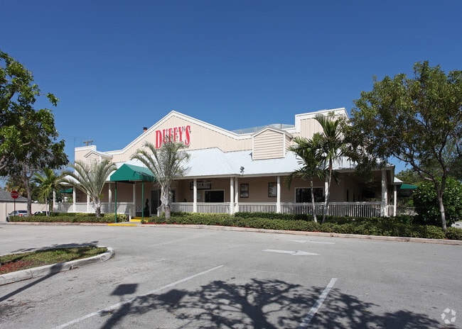
This Property Is For Sale
NEARBY LISTINGS FOR SALE OR LEASE
Property Detail
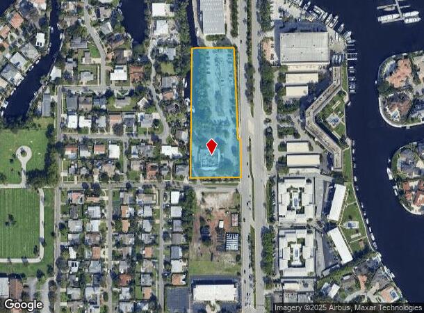
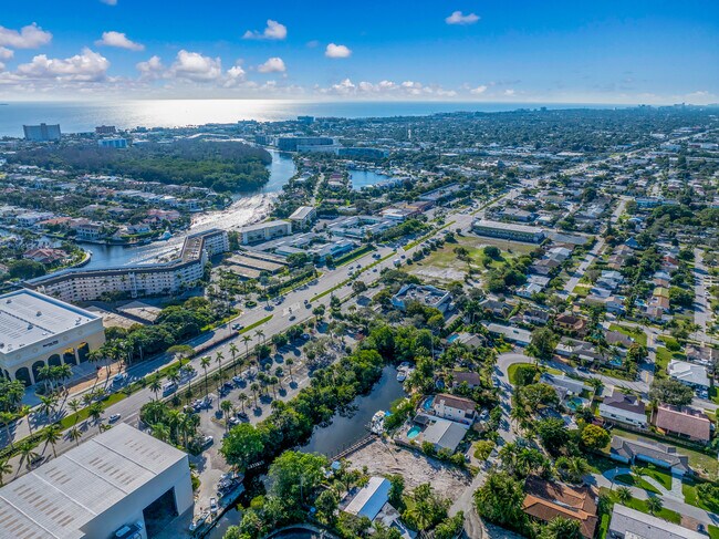
401 N Federal Hwy
47-43-31-00-0490
For Add
Restaurantbuilding
31-47-43 W1/2 OF NW1/4 OF SE1/4 OF SE1/4 LESS STATE RD & LESS POR DESC IN OR 23336/194 FOR ADD RD R/W
AE
Broward
12011C0179J
Florida
2024
3.52 AC
2025
Pompano Beach
010202
South Florida
11,326 SF
Fort Lauderdale-Pompano Beach-Deerfield Beach, FL
DEMOGRAPHICS near 401 N Federal Hwy
1 Mile
3 Mile
5 Mile
2024 Total Population
13,554
112,326
248,163
2029 Population
14,003
116,663
255,263
Pop Growth 2024-2029
+ 3.31%
+ 3.86%
+ 2.86%
Average Age
46
47
45
2024 Total Households
6,479
51,996
107,998
HH Growth 2024-2029
+ 3.40%
+ 4.07%
+ 3.19%
Median Household Inc
$60,316
$63,228
$63,967
Avg Household Size
2.00
2.10
2.10
2024 Avg HH Vehicles
2.00
2.00
2.00
Median Home Value
$457,519
$451,260
$394,310
Median Year Built
1974
1977
1979
Nearby Places
Map Layers
Map Styles
 Street
 Aerial
- Restaurants
- Banks
- Shops
- Fitness
- Groceries
PUBLIC TRANSPORTATION
COMMUTER RAIL
DRIVE
WALK
Distance
6 min
2.5 mi
Deerfield Beach (Tri-County Commuter - South Florida Regional Transportation Authority (Tri-Rail))
DRIVE
WALK
Distance
Deerfield Beach (Tri-County Commuter - South Florida Regional Transportation Authority (Tri-Rail))
7 min
2.7 mi
AIRPORT
Fort Lauderdale/Hollywood International
DRIVE
WALK
Distance
Fort Lauderdale/Hollywood International
32 min
22.2 mi
Palm Beach International
DRIVE
WALK
Distance
Palm Beach International
41 min
30.4 mi
Freight Ports
Port Everglades
DRIVE
WALK
Distance
Port Everglades
31 min
20.8 mi
Nearby Properties
Address
Land Use
TOTAL SIZE
Lot Size
Zoning
Address
Land Use
TOTAL SIZE
Lot Size
Zoning
1,481,767 SF
34.49 AC
R-5
Address
Land Use
TOTAL SIZE
Lot Size
Zoning
501,966 SF
5.82 AC
R1D/DDRI
Address
Land Use
TOTAL SIZE
Lot Size
Zoning
505,418 SF
1.98 AC
DDRI
Address
Land Use
TOTAL SIZE
Lot Size
Zoning
547,946 SF
13.89 AC
DDRI
Address
Land Use
TOTAL SIZE
Lot Size
Zoning
691,385 SF
9.12 AC
DDRI
Address
Land Use
TOTAL SIZE
Lot Size
Zoning
388,471 SF
12.42 AC
R5A-PUD
Address
Land Use
TOTAL SIZE
Lot Size
Zoning
823,639 SF
60.73 AC
PID
Address
Land Use
TOTAL SIZE
Lot Size
Zoning
1,166,083 SF
74.07 AC
I
Address
Land Use
TOTAL SIZE
Lot Size
Zoning
760,812 SF
23.60 AC
MC
Address
Land Use
TOTAL SIZE
Lot Size
Zoning
267,063 SF
2.33 AC
DDRI
Address
Land Use
TOTAL SIZE
Lot Size
Zoning
350,010 SF
8.36 AC
R-3-B
Address
Land Use
TOTAL SIZE
Lot Size
Zoning
275,784 SF
2.27 AC
DDRI
Address
Land Use
TOTAL SIZE
Lot Size
Zoning
240,841 SF
2.08 AC
DDRI
Address
Land Use
TOTAL SIZE
Lot Size
Zoning
285,335 SF
8.56 AC
RM-45
Address
Land Use
TOTAL SIZE
Lot Size
Zoning
230,420 SF
2.64 AC
DDRI
Address
Land Use
TOTAL SIZE
Lot Size
Zoning
20,602 SF
181.05 AC
PL
Address
Land Use
TOTAL SIZE
Lot Size
Zoning
392,222 SF
5.33 AC
RPUD
Address
Land Use
TOTAL SIZE
Lot Size
Zoning
344,341 SF
1.86 AC
DDRI
Address
Land Use
TOTAL SIZE
Lot Size
Zoning
246,122 SF
6.92 AC
TOD
Address
Land Use
TOTAL SIZE
Lot Size
Zoning
272,750 SF
19.59 AC
AR
Address
Land Use
TOTAL SIZE
Lot Size
Zoning
271,199 SF
14.79 AC
AR
Address
Land Use
TOTAL SIZE
Lot Size
Zoning
262,714 SF
15.67 AC
AR
Address
Land Use
TOTAL SIZE
Lot Size
Zoning
497,879 SF
3.94 AC
DDRI
Address
Land Use
TOTAL SIZE
Lot Size
Zoning
386,427 SF
2.24 AC
RM-25
Address
Land Use
TOTAL SIZE
Lot Size
Zoning
374,776 SF
23.52 AC
I-1
Address
Land Use
TOTAL SIZE
Lot Size
Zoning
440,709 SF
22.39 AC
I
Address
Land Use
TOTAL SIZE
Lot Size
Zoning
379,753 SF
3.30 AC
POI
Address
Land Use
TOTAL SIZE
Lot Size
Zoning
160,189 SF
1.09 AC
DDRI
Address
Land Use
TOTAL SIZE
Lot Size
Zoning
435,201 SF
23.78 AC
I-1
Address
Land Use
TOTAL SIZE
Lot Size
Zoning
174,792 SF
0.65 AC
DDRI
The World's #1 Commercial Real Estate Marketplace
Connect with us
© 2025 CoStar Group
The information above has been obtained from sources believed reliable. While we do not doubt its accuracy we have not verified it and make no guarantee, warranty or representation about it. It is your responsibility to independently confirm its accuracy and completeness. Any projections, opinions, assumptions, or estimates used are for example only and do not represent the current or future performance of the property. The value of this transaction to you depends on tax and other factors which should be evaluated by your tax, financial, and legal advisors. You and your advisors should conduct a careful, independent investigation of the property to determine to your satisfaction the suitability of the property for your needs.