Property Record
401 N Kuner Rd, Brighton, CO 80601
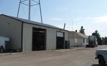

Property Detail
401 N Kuner Rd
1569-06-2-00-005
SECT,TWN,RNG:6-1-66 DESC: BEG AT A PT ON E AND W2 C/L OF SEC 6 W 10 FT FROM A PT SD PT BEING SE COR SW4 NW4 SD SEC TH N ON AN ASSUMED BRG // WITH AND 10 FT W OF E LN W2 NW4 SD SEC 400 FT TH W 784 FT TO THE BANK OF SOUTH PLATTE RIVER TH S 28D 04M E 10
Warehouse
ADAMS
I3
Colorado
AE The base floodplain where base flood elevations are provided. AE Zones are now used on new format FIRMs instead of A1-A30 Zones.
6.63 AC
2024
DIA
2025
Denver
008603
Denver-Aurora-Centennial, CO
6,066 SF
NEARBY LISTINGS FOR SALE OR LEASE
DEMOGRAPHICS near 401 N Kuner Rd
1 mile
3 mile
5 mile
2025 Total Population
6,589
33,026
59,270
2030 Population
6,816
34,476
62,952
Pop Growth 2025-2030
+ 3.45%
+ 4.39%
+ 6.21%
Average Age
37
38
38
2025 Total Households
2,211
11,100
20,004
HH Growth 2025-2030
+ 3.62%
+ 4.76%
+ 6.53%
Median Household Inc
$85,336
$94,989
$115,467
Avg Household Size
2.80
2.90
2.90
2025 Avg HH Vehicles
2.00
2.00
2.00
Median Home Value
$452,354
$494,702
$590,163
Median Year Built
1974
1992
2004
Nearby Places
Map Layers
Map Styles
 Street
 Aerial
Transit
 Traffic
 Biking
Places
Listings with unknown addresses are not visible on the map
- Restaurants
- Banks
- Shops
- Fitness
- Groceries
PUBLIC TRANSPORTATION
AIRPORT
Denver International
Drive
Walk
Distance
Denver International
27 min
21.7 mi
Freight Ports
Tulsa Port Of Catoosa
Drive
Walk
Distance
Tulsa Port Of Catoosa
733 min
715.8 mi
Nearby Properties
Address
Land Use
TOTAL SIZE
Lot Size
Zoning
Address
Land Use
TOTAL SIZE
Lot Size
Zoning
566,409 SF
1.66 AC
Address
Land Use
TOTAL SIZE
Lot Size
Zoning
413,138 SF
20.74 AC
Address
Land Use
TOTAL SIZE
Lot Size
Zoning
113,764 SF
4.24 AC
Address
Land Use
TOTAL SIZE
Lot Size
Zoning
119,714 SF
4.93 AC
Address
Land Use
TOTAL SIZE
Lot Size
Zoning
116,223 SF
7.38 AC
Address
Land Use
TOTAL SIZE
Lot Size
Zoning
71,673 SF
7.59 AC
Address
Land Use
TOTAL SIZE
Lot Size
Zoning
533,981 SF
112.40 AC
Address
Land Use
TOTAL SIZE
Lot Size
Zoning
124,238 SF
62.61 AC
Address
Land Use
TOTAL SIZE
Lot Size
Zoning
161,096 SF
82.69 AC
Address
Land Use
TOTAL SIZE
Lot Size
Zoning
59,923 SF
1.83 AC
Address
Land Use
TOTAL SIZE
Lot Size
Zoning
266,280 SF
12.68 AC
Address
Land Use
TOTAL SIZE
Lot Size
Zoning
223,459 SF
27.46 AC
Address
Land Use
TOTAL SIZE
Lot Size
Zoning
274,367 SF
65.77 AC
Address
Land Use
TOTAL SIZE
Lot Size
Zoning
281,164 SF
15.57 AC
Address
Land Use
TOTAL SIZE
Lot Size
Zoning
91,534 SF
23.03 AC
Address
Land Use
TOTAL SIZE
Lot Size
Zoning
85,398 SF
15 AC
Address
Land Use
TOTAL SIZE
Lot Size
Zoning
182,210 SF
17.01 AC
Address
Land Use
TOTAL SIZE
Lot Size
Zoning
65,492 SF
7.50 AC
Address
Land Use
TOTAL SIZE
Lot Size
Zoning
175,091 SF
9.43 AC
Address
Land Use
TOTAL SIZE
Lot Size
Zoning
60,400 SF
19.12 AC
Address
Land Use
TOTAL SIZE
Lot Size
Zoning
260,526 SF
9.17 AC
Address
Land Use
TOTAL SIZE
Lot Size
Zoning
70,573 SF
7.83 AC
Address
Land Use
TOTAL SIZE
Lot Size
Zoning
40,000 SF
4.10 AC
Address
Land Use
TOTAL SIZE
Lot Size
Zoning
34,345 SF
13.11 AC
A1
Address
Land Use
TOTAL SIZE
Lot Size
Zoning
95,310 SF
20.96 AC
A1
Address
Land Use
TOTAL SIZE
Lot Size
Zoning
59,015 SF
9.44 AC
Address
Land Use
TOTAL SIZE
Lot Size
Zoning
65,892 SF
4.87 AC
Address
Land Use
TOTAL SIZE
Lot Size
Zoning
134,925 SF
3.67 AC
Address
Land Use
TOTAL SIZE
Lot Size
Zoning
67,405 SF
6.96 AC
The World's #1 Commercial Real Estate Marketplace
Connect with us
© 2026 CoStar Group
The information above has been obtained from sources believed reliable. While we do not doubt its accuracy we have not verified it and make no guarantee, warranty or representation about it. It is your responsibility to independently confirm its accuracy and completeness. Any projections, opinions, assumptions, or estimates used are for example only and do not represent the current or future performance of the property. The value of this transaction to you depends on tax and other factors which should be evaluated by your tax, financial, and legal advisors. You and your advisors should conduct a careful, independent investigation of the property to determine to your satisfaction the suitability of the property for your needs.