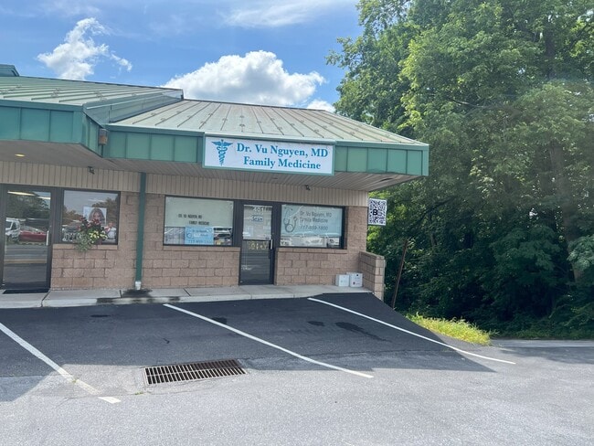
Property Record
401 S 7Th St, Akron, PA 17501

Current Lease Availabilities
NEARBY LISTINGS FOR SALE OR LEASE
-
-
View all Akron listings for lease on LoopNet.com
Property Detail
401 S 7Th St
Lancaster, PA
Akron Electronics Inc
020-42906-0-0000
363 S 7TH ST
Regionalshoppingcenterormallwithanchorstore
Lancaster
X
Pennsylvania
42071C0189F
12
2024
0.25 AC
2025
Lancaster County
012402
Philadelphia
5,331 SF
DEMOGRAPHICS near 401 S 7Th St
1 Mile
3 Mile
5 Mile
2024 Total Population
5,337
29,864
67,015
2029 Population
5,384
30,061
67,308
Pop Growth 2024-2029
+ 0.88%
+ 0.66%
+ 0.44%
Average Age
40
40
41
2024 Total Households
2,119
11,680
25,453
HH Growth 2024-2029
+ 0.94%
+ 0.74%
+ 0.46%
Median Household Inc
$70,063
$68,333
$75,719
Avg Household Size
2.50
2.50
2.60
2024 Avg HH Vehicles
2.00
2.00
2.00
Median Home Value
$206,840
$222,110
$253,637
Median Year Built
1973
1978
1980
Nearby Places
Map Layers
Map Styles
 Street
 Aerial
- Restaurants
- Banks
- Shops
- Fitness
- Groceries
PUBLIC TRANSPORTATION
COMMUTER RAIL
Lancaster (Keystone Service - Amtrak, Pennsylvanian - Amtrak)
DRIVE
WALK
Distance
Lancaster (Keystone Service - Amtrak, Pennsylvanian - Amtrak)
14 min
9.7 mi
AIRPORT
Harrisburg International
DRIVE
WALK
Distance
Harrisburg International
49 min
39.0 mi
Freight Ports
Port of Wilmington, RI
DRIVE
WALK
Distance
Port of Wilmington, RI
94 min
53.8 mi
Nearby Properties
Address
Land Use
TOTAL SIZE
Lot Size
Zoning
Address
Land Use
TOTAL SIZE
Lot Size
Zoning
251,634 SF
16.28 AC
Address
Land Use
TOTAL SIZE
Lot Size
Zoning
226,686 SF
28 AC
RLD
Address
Land Use
TOTAL SIZE
Lot Size
Zoning
229,049 SF
26.80 AC
RLD
Address
Land Use
TOTAL SIZE
Lot Size
Zoning
166,771 SF
10.76 AC
Address
Land Use
TOTAL SIZE
Lot Size
Zoning
155,373 SF
4.50 AC
Address
Land Use
TOTAL SIZE
Lot Size
Zoning
90,600 SF
6.98 AC
Address
Land Use
TOTAL SIZE
Lot Size
Zoning
135,900 SF
11.79 AC
Address
Land Use
TOTAL SIZE
Lot Size
Zoning
69,993 SF
Address
Land Use
TOTAL SIZE
Lot Size
Zoning
103,448 SF
79.90 AC
A
Address
Land Use
TOTAL SIZE
Lot Size
Zoning
122,512 SF
22.36 AC
I
Address
Land Use
TOTAL SIZE
Lot Size
Zoning
88,413 SF
5.30 AC
RMD
Address
Land Use
TOTAL SIZE
Lot Size
Zoning
85,104 SF
24.20 AC
Address
Land Use
TOTAL SIZE
Lot Size
Zoning
123,018 SF
14.30 AC
HC
Address
Land Use
TOTAL SIZE
Lot Size
Zoning
75,760 SF
4.85 AC
RMD
Address
Land Use
TOTAL SIZE
Lot Size
Zoning
73,648 SF
10.20 AC
R-1
Address
Land Use
TOTAL SIZE
Lot Size
Zoning
92,217 SF
11.50 AC
C
Address
Land Use
TOTAL SIZE
Lot Size
Zoning
33,134 SF
0.42 AC
NC-2
Address
Land Use
TOTAL SIZE
Lot Size
Zoning
59,996 SF
6 AC
Address
Land Use
TOTAL SIZE
Lot Size
Zoning
55,896 SF
3.49 AC
Address
Land Use
TOTAL SIZE
Lot Size
Zoning
51,954 SF
11.80 AC
R-1
Address
Land Use
TOTAL SIZE
Lot Size
Zoning
81,044 SF
4.67 AC
Address
Land Use
TOTAL SIZE
Lot Size
Zoning
104,828 SF
5.94 AC
I
Address
Land Use
TOTAL SIZE
Lot Size
Zoning
50,888 SF
5.70 AC
RLD
Address
Land Use
TOTAL SIZE
Lot Size
Zoning
64,500 SF
19.60 AC
RLD
Address
Land Use
TOTAL SIZE
Lot Size
Zoning
220,374 SF
20.62 AC
I
Address
Land Use
TOTAL SIZE
Lot Size
Zoning
16,054 SF
4.50 AC
HC
Address
Land Use
TOTAL SIZE
Lot Size
Zoning
14.50 AC
I
Address
Land Use
TOTAL SIZE
Lot Size
Zoning
47,810 SF
5.08 AC
RLD
Address
Land Use
TOTAL SIZE
Lot Size
Zoning
83,288 SF
5.86 AC
RHD
Address
Land Use
TOTAL SIZE
Lot Size
Zoning
68,376 SF
6 AC
HC
The World's #1 Commercial Real Estate Marketplace
Connect with us
© 2025 CoStar Group
The information above has been obtained from sources believed reliable. While we do not doubt its accuracy we have not verified it and make no guarantee, warranty or representation about it. It is your responsibility to independently confirm its accuracy and completeness. Any projections, opinions, assumptions, or estimates used are for example only and do not represent the current or future performance of the property. The value of this transaction to you depends on tax and other factors which should be evaluated by your tax, financial, and legal advisors. You and your advisors should conduct a careful, independent investigation of the property to determine to your satisfaction the suitability of the property for your needs.