Property Record
401 S Valley Dr, Las Cruces, NM 88005


This Property Is For Sale
NEARBY LISTINGS FOR SALE OR LEASE
Property Detail
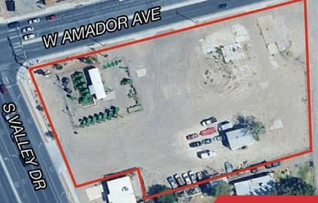
401 S Valley Dr
Las Cruces, NM
Rountree Suburban Farm
19-11198
SUBD: ROUNTREE SUBURBAN FARM TRACTS REPLAT NO 2 (2412332) LOT: 1A S: 13 T: 23S R: 1E
Commercialacreage
Dona Ana
X
New Mexico
35013C1091G
1a
2023
1.89 AC
2025
Downtown Las Cruces
0002014004
Other Market Areas
672 SF
DEMOGRAPHICS near 401 S Valley Dr
1 Mile
3 Mile
5 Mile
2024 Total Population
6,372
66,067
117,959
2029 Population
6,646
68,664
123,002
Pop Growth 2024-2029
+ 4.30%
+ 3.93%
+ 4.28%
Average Age
40
38
39
2024 Total Households
2,748
26,416
48,264
HH Growth 2024-2029
+ 4.44%
+ 4.15%
+ 4.45%
Median Household Inc
$52,378
$40,390
$52,437
Avg Household Size
2.20
2.30
2.30
2024 Avg HH Vehicles
1.00
2.00
2.00
Median Home Value
$192,704
$179,282
$238,627
Median Year Built
1974
1978
1985
Nearby Places
Map Layers
Map Styles
 Street
 Aerial
- Restaurants
- Banks
- Shops
- Fitness
- Groceries
Nearby Properties
Address
Land Use
TOTAL SIZE
Lot Size
Zoning
Address
Land Use
TOTAL SIZE
Lot Size
Zoning
106,866 SF
10.61 AC
R1
Address
Land Use
TOTAL SIZE
Lot Size
Zoning
206,137 SF
9.96 AC
R1
Address
Land Use
TOTAL SIZE
Lot Size
Zoning
207,825 SF
25.73 AC
A2
Address
Land Use
TOTAL SIZE
Lot Size
Zoning
213,046 SF
33.55 AC
R1
Address
Land Use
TOTAL SIZE
Lot Size
Zoning
394,043 SF
26.74 AC
C2
Address
Land Use
TOTAL SIZE
Lot Size
Zoning
463,811 SF
36.43 AC
C2
Address
Land Use
TOTAL SIZE
Lot Size
Zoning
52,991 SF
5.95 AC
C2
Address
Land Use
TOTAL SIZE
Lot Size
Zoning
65,535 SF
5.64 AC
R1
Address
Land Use
TOTAL SIZE
Lot Size
Zoning
242,177 SF
21.36 AC
M1
Address
Land Use
TOTAL SIZE
Lot Size
Zoning
27,528 SF
4.65 AC
R1
Address
Land Use
TOTAL SIZE
Lot Size
Zoning
42,295 SF
7.45 AC
C2
Address
Land Use
TOTAL SIZE
Lot Size
Zoning
136,629 SF
15.78 AC
C2
Address
Land Use
TOTAL SIZE
Lot Size
Zoning
79,362 SF
5.90 AC
C2
Address
Land Use
TOTAL SIZE
Lot Size
Zoning
74,625 SF
6.40 AC
C2
Address
Land Use
TOTAL SIZE
Lot Size
Zoning
121,855 SF
12.59 AC
C2
Address
Land Use
TOTAL SIZE
Lot Size
Zoning
69,890 SF
Address
Land Use
TOTAL SIZE
Lot Size
Zoning
17,812 SF
2.65 AC
CBD
Address
Land Use
TOTAL SIZE
Lot Size
Zoning
136,377 SF
42.51 AC
A2
Address
Land Use
TOTAL SIZE
Lot Size
Zoning
100,145 SF
8.46 AC
C2
Address
Land Use
TOTAL SIZE
Lot Size
Zoning
11.35 AC
M1
Address
Land Use
TOTAL SIZE
Lot Size
Zoning
29,222 SF
4.96 AC
M1
Address
Land Use
TOTAL SIZE
Lot Size
Zoning
93,663 SF
4.89 AC
C2
Address
Land Use
TOTAL SIZE
Lot Size
Zoning
88,424 SF
75.20 AC
M1
Address
Land Use
TOTAL SIZE
Lot Size
Zoning
85,310 SF
5.23 AC
R2
Address
Land Use
TOTAL SIZE
Lot Size
Zoning
31,343 SF
4.60 AC
C2
Address
Land Use
TOTAL SIZE
Lot Size
Zoning
107,608 SF
6.04 AC
R3
Address
Land Use
TOTAL SIZE
Lot Size
Zoning
109,641 SF
12.01 AC
M1
Address
Land Use
TOTAL SIZE
Lot Size
Zoning
47,612 SF
7.41 AC
C2
The World's #1 Commercial Real Estate Marketplace
Connect with us
© 2026 CoStar Group
The information above has been obtained from sources believed reliable. While we do not doubt its accuracy we have not verified it and make no guarantee, warranty or representation about it. It is your responsibility to independently confirm its accuracy and completeness. Any projections, opinions, assumptions, or estimates used are for example only and do not represent the current or future performance of the property. The value of this transaction to you depends on tax and other factors which should be evaluated by your tax, financial, and legal advisors. You and your advisors should conduct a careful, independent investigation of the property to determine to your satisfaction the suitability of the property for your needs.