No Photo
Property Record
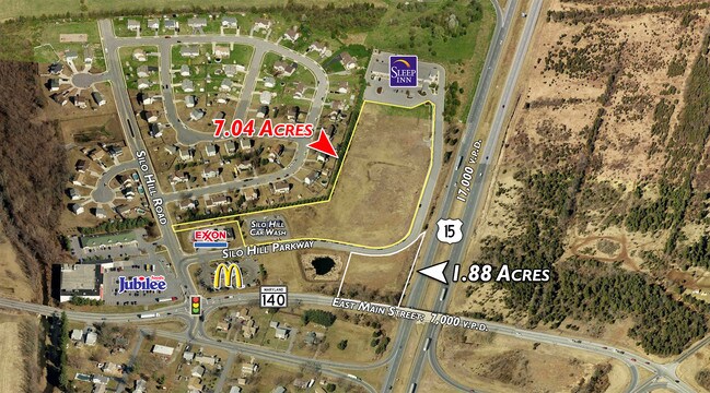
401 Silo Hill Pkwy, Emmitsburg, MD 21727

NEARBY LISTINGS FOR SALE OR LEASE
-
-
No Photo
-
View all Emmitsburg listings for sale on LoopNet.com
Property Detail
401 Silo Hill Pkwy
Washington-Arlington-Alexandria, DC-VA-MD-WV
Silo Hill
05-588367
IMPS REMAINDER NORTH 4.13 ACRES SILO HILL
Commercialnec
Frederick
X
Maryland
24021C0054E
4.13 AC
2024
Frederick
2025
Washington, DC
766800
DEMOGRAPHICS near 401 Silo Hill Pkwy
1 Mile
3 Mile
5 Mile
2024 Total Population
2,362
5,925
11,661
2029 Population
2,647
6,509
12,528
Pop Growth 2024-2029
+ 12.07%
+ 9.86%
+ 7.44%
Average Age
41
38
40
2024 Total Households
877
1,768
3,731
HH Growth 2024-2029
+ 12.43%
+ 10.92%
+ 7.75%
Median Household Inc
$74,214
$78,657
$81,508
Avg Household Size
2.60
2.50
2.50
2024 Avg HH Vehicles
2.00
2.00
2.00
Median Home Value
$274,025
$309,485
$314,892
Median Year Built
1984
1982
1984
Nearby Places
Map Layers
Map Styles
 Street
 Aerial
- Restaurants
- Banks
- Shops
- Fitness
- Groceries
PUBLIC TRANSPORTATION
AIRPORT
Hagerstown Regional/Richard A Henson Field
DRIVE
WALK
Distance
Hagerstown Regional/Richard A Henson Field
49 min
27.5 mi
Freight Ports
Port of Baltimore
DRIVE
WALK
Distance
Port of Baltimore
86 min
57.2 mi
SALE & LEASE HISTORY
LISTING DATE
SALE/LEASE

Sep 24, 2016
For Sale
Nearby Properties
Address
Land Use
TOTAL SIZE
Lot Size
Zoning
Address
Land Use
TOTAL SIZE
Lot Size
Zoning
987,918 SF
98.99 AC
RC
Address
Land Use
TOTAL SIZE
Lot Size
Zoning
86,780 SF
107.10 AC
A
Address
Land Use
TOTAL SIZE
Lot Size
Zoning
57,498 SF
7.18 AC
INST
Address
Land Use
TOTAL SIZE
Lot Size
Zoning
81,951 SF
76 AC
OS
Address
Land Use
TOTAL SIZE
Lot Size
Zoning
8,400 SF
15.29 AC
GC
Address
Land Use
TOTAL SIZE
Lot Size
Zoning
51,860 SF
5.82 AC
ORI
Address
Land Use
TOTAL SIZE
Lot Size
Zoning
29,086 SF
29.90 AC
INST
Address
Land Use
TOTAL SIZE
Lot Size
Zoning
38,607 SF
2.29 AC
B2
Address
Land Use
TOTAL SIZE
Lot Size
Zoning
38,772 SF
2.01 AC
INST
Address
Land Use
TOTAL SIZE
Lot Size
Zoning
21,547 SF
35 AC
RC
Address
Land Use
TOTAL SIZE
Lot Size
Zoning
2,778 SF
266.27 AC
A
Address
Land Use
TOTAL SIZE
Lot Size
Zoning
36,016 SF
9.25 AC
OS
Address
Land Use
TOTAL SIZE
Lot Size
Zoning
36,958 SF
19.33 AC
GC
Address
Land Use
TOTAL SIZE
Lot Size
Zoning
21,168 SF
2.67 AC
IP
Address
Land Use
TOTAL SIZE
Lot Size
Zoning
27,516 SF
4.01 AC
IP
Address
Land Use
TOTAL SIZE
Lot Size
Zoning
29,221 SF
1.72 AC
B2
Address
Land Use
TOTAL SIZE
Lot Size
Zoning
18,718 SF
0.74 AC
A
Address
Land Use
TOTAL SIZE
Lot Size
Zoning
9,045 SF
0.96 AC
GC
Address
Land Use
TOTAL SIZE
Lot Size
Zoning
23,055 SF
4.44 AC
IP
Address
Land Use
TOTAL SIZE
Lot Size
Zoning
18,998 SF
0.45 AC
VZ
Address
Land Use
TOTAL SIZE
Lot Size
Zoning
14,350 SF
4.41 AC
IP
Address
Land Use
TOTAL SIZE
Lot Size
Zoning
10,834 SF
2.21 AC
R1
Address
Land Use
TOTAL SIZE
Lot Size
Zoning
10,100 SF
1.53 AC
B2
Address
Land Use
TOTAL SIZE
Lot Size
Zoning
3,124 SF
80.64 AC
I
Address
Land Use
TOTAL SIZE
Lot Size
Zoning
10,160 SF
0.74 AC
R1
Address
Land Use
TOTAL SIZE
Lot Size
Zoning
16,872 SF
1.03 AC
VZ
Address
Land Use
TOTAL SIZE
Lot Size
Zoning
12,063 SF
4.46 AC
GI
Address
Land Use
TOTAL SIZE
Lot Size
Zoning
33,855 SF
1.33 AC
VZ
Address
Land Use
TOTAL SIZE
Lot Size
Zoning
44.12 AC
B2
Address
Land Use
TOTAL SIZE
Lot Size
Zoning
12,978 SF
2.33 AC
GC
The World's #1 Commercial Real Estate Marketplace
Connect with us
© 2026 CoStar Group
The information above has been obtained from sources believed reliable. While we do not doubt its accuracy we have not verified it and make no guarantee, warranty or representation about it. It is your responsibility to independently confirm its accuracy and completeness. Any projections, opinions, assumptions, or estimates used are for example only and do not represent the current or future performance of the property. The value of this transaction to you depends on tax and other factors which should be evaluated by your tax, financial, and legal advisors. You and your advisors should conduct a careful, independent investigation of the property to determine to your satisfaction the suitability of the property for your needs.