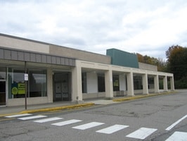
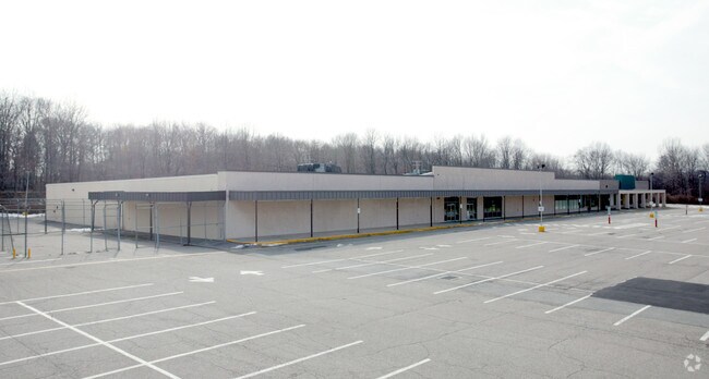
Property Record
401 State Route 57 E, Washington, NJ 07882

Property Detail
401 State Route 57 E
22-00046-0000-00013
Warren
Commercialnec
New Jersey
GC
13
B and X Area of moderate flood hazard, usually the area between the limits of the 100-year and 500-year floods.
9.80 AC
2024
Warren County
2025
Northern New Jersey
031900
Allentown-Bethlehem-Easton, PA-NJ
6,630 SF
NEARBY LISTINGS FOR SALE OR LEASE
DEMOGRAPHICS near 401 State Route 57 E
1 mile
3 mile
5 mile
2025 Total Population
4,761
16,405
28,168
2030 Population
4,902
16,796
28,764
Pop Growth 2025-2030
+ 2.96%
+ 2.38%
+ 2.12%
Average Age
42
43
44
2025 Total Households
1,868
6,378
11,069
HH Growth 2025-2030
+ 2.84%
+ 2.21%
+ 2.01%
Median Household Inc
$96,962
$104,723
$107,914
Avg Household Size
2.50
2.50
2.50
2025 Avg HH Vehicles
2.00
2.00
2.00
Median Home Value
$315,187
$355,059
$366,541
Median Year Built
1964
1970
1971
Nearby Places
Map Layers
Map Styles
 Street
 Aerial
Transit
 Traffic
 Biking
Places
Listings with unknown addresses are not visible on the map
- Restaurants
- Banks
- Shops
- Fitness
- Groceries
PUBLIC TRANSPORTATION
AIRPORT
Lehigh Valley International
Drive
Walk
Distance
Lehigh Valley International
49 min
28.6 mi
Trenton Mercer
Drive
Walk
Distance
Trenton Mercer
64 min
40.1 mi
Freight Ports
Maher Terminal
Drive
Walk
Distance
Maher Terminal
74 min
55.0 mi
SALE & LEASE HISTORY
LISTING DATE
SALE/LEASE

Sep 25, 2016
For Lease
Nearby Properties
Address
Land Use
TOTAL SIZE
Lot Size
Zoning
Address
Land Use
TOTAL SIZE
Lot Size
Zoning
Address
Land Use
TOTAL SIZE
Lot Size
Zoning
46.85 AC
R-40
Address
Land Use
TOTAL SIZE
Lot Size
Zoning
Address
Land Use
TOTAL SIZE
Lot Size
Zoning
32.90 AC
PL
Address
Land Use
TOTAL SIZE
Lot Size
Zoning
22.84 AC
HC
Address
Land Use
TOTAL SIZE
Lot Size
Zoning
226,375 SF
50.41 AC
Address
Land Use
TOTAL SIZE
Lot Size
Zoning
20.43 AC
R4
Address
Land Use
TOTAL SIZE
Lot Size
Zoning
6.24 AC
PVD
Address
Land Use
TOTAL SIZE
Lot Size
Zoning
73,058 SF
19.68 AC
Address
Land Use
TOTAL SIZE
Lot Size
Zoning
Address
Land Use
TOTAL SIZE
Lot Size
Zoning
Address
Land Use
TOTAL SIZE
Lot Size
Zoning
15.80 AC
I
Address
Land Use
TOTAL SIZE
Lot Size
Zoning
1,280 SF
240.85 AC
PVD
Address
Land Use
TOTAL SIZE
Lot Size
Zoning
1.87 AC
PVD
Address
Land Use
TOTAL SIZE
Lot Size
Zoning
5.40 AC
OR
Address
Land Use
TOTAL SIZE
Lot Size
Zoning
5.50 AC
OR
Address
Land Use
TOTAL SIZE
Lot Size
Zoning
5.08 AC
HC
Address
Land Use
TOTAL SIZE
Lot Size
Zoning
9.50 AC
PL
Address
Land Use
TOTAL SIZE
Lot Size
Zoning
4.89 AC
R4
Address
Land Use
TOTAL SIZE
Lot Size
Zoning
12,448 SF
2 AC
RC
Address
Land Use
TOTAL SIZE
Lot Size
Zoning
4,082 SF
9.58 AC
R2
Address
Land Use
TOTAL SIZE
Lot Size
Zoning
38,415 SF
4 AC
Address
Land Use
TOTAL SIZE
Lot Size
Zoning
11.77 AC
VR
Address
Land Use
TOTAL SIZE
Lot Size
Zoning
1.98 AC
PVD
Address
Land Use
TOTAL SIZE
Lot Size
Zoning
2.61 AC
PI
Address
Land Use
TOTAL SIZE
Lot Size
Zoning
2,648 SF
4.97 AC
R-20
Address
Land Use
TOTAL SIZE
Lot Size
Zoning
1.70 AC
HC
Address
Land Use
TOTAL SIZE
Lot Size
Zoning
7.93 AC
R4
Address
Land Use
TOTAL SIZE
Lot Size
Zoning
7,500 SF
6.05 AC
HC
Address
Land Use
TOTAL SIZE
Lot Size
Zoning
2,010 SF
1.68 AC
B1
The World's #1 Commercial Real Estate Marketplace
Connect with us
© 2026 CoStar Group
The information above has been obtained from sources believed reliable. While we do not doubt its accuracy we have not verified it and make no guarantee, warranty or representation about it. It is your responsibility to independently confirm its accuracy and completeness. Any projections, opinions, assumptions, or estimates used are for example only and do not represent the current or future performance of the property. The value of this transaction to you depends on tax and other factors which should be evaluated by your tax, financial, and legal advisors. You and your advisors should conduct a careful, independent investigation of the property to determine to your satisfaction the suitability of the property for your needs.