Property Record
401 Sw 2Nd Pl, Dania, FL 33004
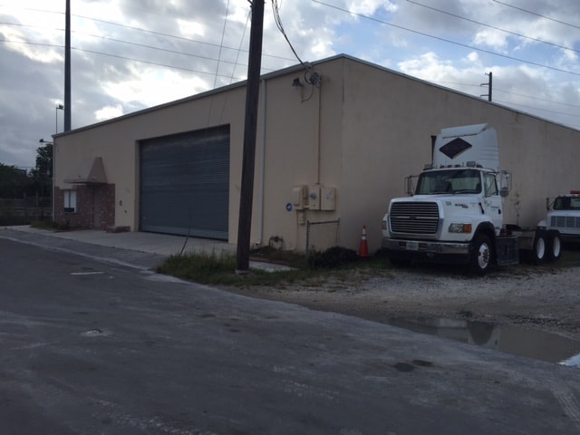


Property Detail
401 Sw 2Nd Pl
51-42-03-38-0430
VICTORY HEIGHTS 21-2 B LOT 6,7 BLK 2
Warehouse
Broward
NBHD-MU
Florida
AH Areas with a 1% annual chance of shallow flooding, usually in the form of a pond, withan average depth ranging from 1 to 3 feet. These areas have a 26% chance of flooding over the life of a 30-year mortgage.
6,7
2025
0.19 AC
2026
Southeast Broward
080500
South Florida
5,840 SF
Fort Lauderdale-Pompano Beach-Sunrise, FL
NEARBY LISTINGS FOR SALE OR LEASE
DEMOGRAPHICS near 401 Sw 2Nd Pl
1 mile
3 mile
5 mile
2025 Total Population
18,545
101,756
310,064
2030 Population
20,090
108,912
333,559
Pop Growth 2025-2030
+ 8.33%
+ 7.03%
+ 7.58%
Average Age
43
42
43
2025 Total Households
7,786
43,072
132,214
HH Growth 2025-2030
+ 8.04%
+ 6.64%
+ 7.59%
Median Household Inc
$48,991
$66,127
$69,476
Avg Household Size
2.30
2.30
2.20
2025 Avg HH Vehicles
1.00
1.00
2.00
Median Home Value
$487,459
$516,046
$474,415
Median Year Built
1975
1972
1972
Nearby Places
Map Layers
Map Styles
 Street
 Aerial
Layers
 Traffic
 Biking
Places
Listings with unknown addresses are not visible on the map
- Restaurants
- Banks
- Shops
- Fitness
- Groceries
PUBLIC TRANSPORTATION
COMMUTER RAIL
Fort Lauderdale Airport Station (Mangonia Park - Miami Airport - Tri-Rail, West Palm Beach - MiamiCentral - Tri-Rail)
Drive
Walk
Distance
Fort Lauderdale Airport Station (Mangonia Park - Miami Airport - Tri-Rail, West Palm Beach - MiamiCentral - Tri-Rail)
6 min
2.6 mi
Sheridan Street (Tri-County Commuter - South Florida Regional Transportation Authority (Tri-Rail))
Drive
Walk
Distance
Sheridan Street (Tri-County Commuter - South Florida Regional Transportation Authority (Tri-Rail))
7 min
3.1 mi
AIRPORT
Fort Lauderdale/Hollywood International
Drive
Walk
Distance
Fort Lauderdale/Hollywood International
8 min
3.7 mi
Miami International
Drive
Walk
Distance
Miami International
43 min
26.8 mi
Freight Ports
Port Everglades
Drive
Walk
Distance
Port Everglades
8 min
4.2 mi
Nearby Properties
Address
Land Use
TOTAL SIZE
Lot Size
Zoning
Address
Land Use
TOTAL SIZE
Lot Size
Zoning
4,648,575 SF
887.02 AC
AT
Address
Land Use
TOTAL SIZE
Lot Size
Zoning
3,629,204 SF
159.43 AC
AT
Address
Land Use
TOTAL SIZE
Lot Size
Zoning
2,786,552 SF
25.77 AC
HD
Address
Land Use
TOTAL SIZE
Lot Size
Zoning
666,326 SF
4.62 AC
GU
Address
Land Use
TOTAL SIZE
Lot Size
Zoning
964,376 SF
258.71 AC
AT
Address
Land Use
TOTAL SIZE
Lot Size
Zoning
615,595 SF
8.50 AC
PMUD
Address
Land Use
TOTAL SIZE
Lot Size
Zoning
654,212 SF
3.59 AC
Address
Land Use
TOTAL SIZE
Lot Size
Zoning
835,943 SF
42.65 AC
PMUD
Address
Land Use
TOTAL SIZE
Lot Size
Zoning
103,053 SF
175.58 AC
PEDD
Address
Land Use
TOTAL SIZE
Lot Size
Zoning
311,472 SF
136.47 AC
PEDD
Address
Land Use
TOTAL SIZE
Lot Size
Zoning
272,634 SF
32.39 AC
PMUD
Address
Land Use
TOTAL SIZE
Lot Size
Zoning
543,212 SF
3.21 AC
PMUD
Address
Land Use
TOTAL SIZE
Lot Size
Zoning
615,846 SF
2.06 AC
CC
Address
Land Use
TOTAL SIZE
Lot Size
Zoning
498,512 SF
1.05 AC
YC
Address
Land Use
TOTAL SIZE
Lot Size
Zoning
376,559 SF
14.53 AC
PD
Address
Land Use
TOTAL SIZE
Lot Size
Zoning
434,698 SF
4.10 AC
GTWY-MU
Address
Land Use
TOTAL SIZE
Lot Size
Zoning
639,300 SF
1.45 AC
CC
Address
Land Use
TOTAL SIZE
Lot Size
Zoning
241,796 SF
1.64 AC
BRT-25-C
Address
Land Use
TOTAL SIZE
Lot Size
Zoning
571,570 SF
1.54 AC
ND-3
Address
Land Use
TOTAL SIZE
Lot Size
Zoning
579,420 SF
1.68 AC
ND-3
Address
Land Use
TOTAL SIZE
Lot Size
Zoning
267,280 SF
11.69 AC
RS-6
Address
Land Use
TOTAL SIZE
Lot Size
Zoning
523,233 SF
2.30 AC
ND-3
Address
Land Use
TOTAL SIZE
Lot Size
Zoning
438,370 SF
1.17 AC
PS-3
Address
Land Use
TOTAL SIZE
Lot Size
Zoning
296,691 SF
1.86 AC
PMUD
Address
Land Use
TOTAL SIZE
Lot Size
Zoning
429,869 SF
2.43 AC
PMUD-SL
Address
Land Use
TOTAL SIZE
Lot Size
Zoning
218,137 SF
7.13 AC
RM-2
Address
Land Use
TOTAL SIZE
Lot Size
Zoning
235,568 SF
14.30 AC
IM-3
Address
Land Use
TOTAL SIZE
Lot Size
Zoning
313,850 SF
0.80 AC
Address
Land Use
TOTAL SIZE
Lot Size
Zoning
287,160 SF
16.39 AC
RM-18
Address
Land Use
TOTAL SIZE
Lot Size
Zoning
552,737 SF
11.76 AC
C-4
The World's #1 Commercial Real Estate Marketplace
Connect with us
© 2026 CoStar Group
The information above has been obtained from sources believed reliable. While we do not doubt its accuracy we have not verified it and make no guarantee, warranty or representation about it. It is your responsibility to independently confirm its accuracy and completeness. Any projections, opinions, assumptions, or estimates used are for example only and do not represent the current or future performance of the property. The value of this transaction to you depends on tax and other factors which should be evaluated by your tax, financial, and legal advisors. You and your advisors should conduct a careful, independent investigation of the property to determine to your satisfaction the suitability of the property for your needs.