Property Record
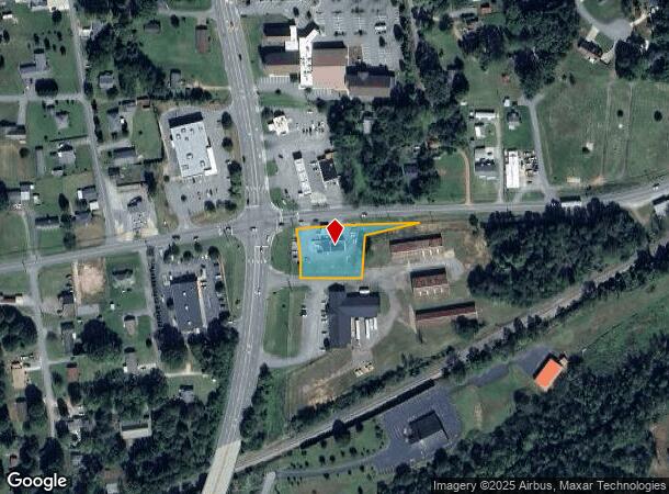
401 Us Highway 70, Connelly Springs, NC 28612
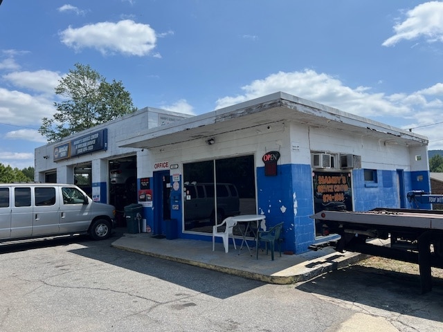
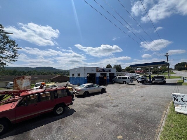
This Property Is For Sale
NEARBY LISTINGS FOR SALE OR LEASE
Property Detail
401 Us Highway 70
30896
401 US 70 CONNELLY SPRINGS, NC 28612
Servicestation
Burke
X
North Carolina
3710275300J
0.69 AC
2025
Burke County
2025
Charlotte
021202
Hickory-Lenoir-Morganton, NC
1,792 SF
DEMOGRAPHICS near 401 Us Highway 70
1 Mile
3 Mile
5 Mile
2024 Total Population
1,527
9,197
21,775
2029 Population
1,528
9,191
21,628
Pop Growth 2024-2029
+ 0.07%
(0.07%)
(0.68%)
Average Age
46
46
46
2024 Total Households
611
3,813
8,928
HH Growth 2024-2029
+ 0.16%
(0.05%)
(0.67%)
Median Household Inc
$67,500
$65,371
$61,676
Avg Household Size
2.40
2.30
2.40
2024 Avg HH Vehicles
2.00
2.00
2.00
Median Home Value
$168,009
$167,237
$161,481
Median Year Built
1971
1974
1978
Nearby Places
- Restaurants
- Banks
- Shops
- Fitness
- Groceries
Nearby Properties
Address
Land Use
TOTAL SIZE
Lot Size
Zoning
Address
Land Use
TOTAL SIZE
Lot Size
Zoning
GENERAL BU
Address
Land Use
TOTAL SIZE
Lot Size
Zoning
GENERAL MA
Address
Land Use
TOTAL SIZE
Lot Size
Zoning
RESIDENTIA
Address
Land Use
TOTAL SIZE
Lot Size
Zoning
5,868 SF
15.83 AC
GENERAL MA
Address
Land Use
TOTAL SIZE
Lot Size
Zoning
128 SF
R-12 RESID
Address
Land Use
TOTAL SIZE
Lot Size
Zoning
42,565 SF
5.10 AC
GENERAL BU
Address
Land Use
TOTAL SIZE
Lot Size
Zoning
51,742 SF
R-8 RESIDE
Address
Land Use
TOTAL SIZE
Lot Size
Zoning
1,668 SF
R-8 RESIDE
Address
Land Use
TOTAL SIZE
Lot Size
Zoning
194,159 SF
41.19 AC
GENERAL MA
Address
Land Use
TOTAL SIZE
Lot Size
Zoning
205,525 SF
11.79 AC
GENERAL MA
Address
Land Use
TOTAL SIZE
Lot Size
Zoning
7,416 SF
RES LOW DE
Address
Land Use
TOTAL SIZE
Lot Size
Zoning
14,550 SF
1.56 AC
HIGHWAY BU
Address
Land Use
TOTAL SIZE
Lot Size
Zoning
76.07 AC
GENERAL MA
Address
Land Use
TOTAL SIZE
Lot Size
Zoning
163,919 SF
16.96 AC
GENERAL MA
Address
Land Use
TOTAL SIZE
Lot Size
Zoning
10,125 SF
1.38 AC
HIGHWAY BU
Address
Land Use
TOTAL SIZE
Lot Size
Zoning
6,576 SF
6.06 AC
R-8 RESIDE
Address
Land Use
TOTAL SIZE
Lot Size
Zoning
3,071 SF
4.82 AC
R-12A RESI
Address
Land Use
TOTAL SIZE
Lot Size
Zoning
2,218 SF
6.10 AC
R-8 RESIDE
Address
Land Use
TOTAL SIZE
Lot Size
Zoning
37,974 SF
7.27 AC
GENERAL BU
Address
Land Use
TOTAL SIZE
Lot Size
Zoning
119,915 SF
26.49 AC
GENERAL MA
Address
Land Use
TOTAL SIZE
Lot Size
Zoning
56,633 SF
17.91 AC
GENERAL MA
Address
Land Use
TOTAL SIZE
Lot Size
Zoning
R-12 RESID
Address
Land Use
TOTAL SIZE
Lot Size
Zoning
13,437 SF
OFFICE-INS
Address
Land Use
TOTAL SIZE
Lot Size
Zoning
11,654 SF
OFFICE-INS
Address
Land Use
TOTAL SIZE
Lot Size
Zoning
87,061 SF
25.12 AC
GENERAL MA
Address
Land Use
TOTAL SIZE
Lot Size
Zoning
29,812 SF
R-12 RESID
Address
Land Use
TOTAL SIZE
Lot Size
Zoning
5,256 SF
4.13 AC
R-8 RESIDE
Address
Land Use
TOTAL SIZE
Lot Size
Zoning
31,872 SF
CENTRAL BU
Address
Land Use
TOTAL SIZE
Lot Size
Zoning
2,836 SF
0.80 AC
CENTRAL BU
Address
Land Use
TOTAL SIZE
Lot Size
Zoning
27,028 SF
0.88 AC
R-8 RESIDE
The World's #1 Commercial Real Estate Marketplace
Connect with us
© 2025 CoStar Group
The information above has been obtained from sources believed reliable. While we do not doubt its accuracy we have not verified it and make no guarantee, warranty or representation about it. It is your responsibility to independently confirm its accuracy and completeness. Any projections, opinions, assumptions, or estimates used are for example only and do not represent the current or future performance of the property. The value of this transaction to you depends on tax and other factors which should be evaluated by your tax, financial, and legal advisors. You and your advisors should conduct a careful, independent investigation of the property to determine to your satisfaction the suitability of the property for your needs.