Property Record
401 Vinton Rd, Anthony, TX 79821
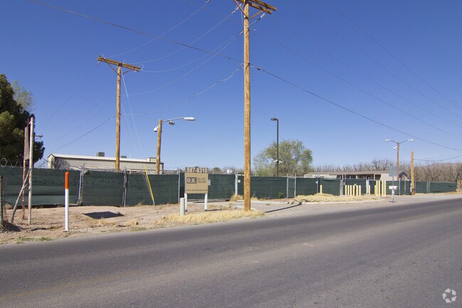

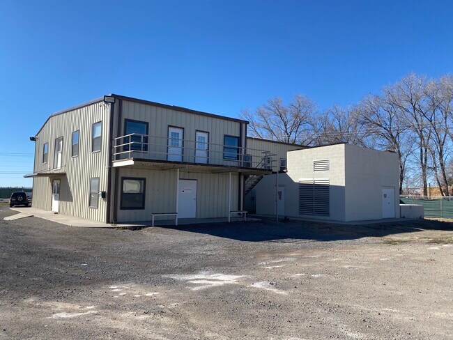
Property Detail
401 Vinton Rd
El Paso, TX
20 UPPER VALLEY TR 10-B (2.024 AC) 10-B-1 (4.0 AC) (6.0240 AC)
U819-000-020K-0200
EL PASO
Commercialnec
Texas
2024
6.02 AC
2025
Outlying El Paso County
010203
El Paso
18,276 SF
NEARBY LISTINGS FOR SALE OR LEASE
-
-
View all Anthony listings for lease on LoopNet.com
DEMOGRAPHICS near 401 Vinton Rd
1 mile
3 mile
5 mile
2024 Total Population
1,369
15,238
36,806
2029 Population
1,399
15,457
37,439
Pop Growth 2024-2029
+ 2.19%
+ 1.44%
+ 1.72%
Average Age
41
38
37
2024 Total Households
290
4,580
11,497
HH Growth 2024-2029
+ 2.41%
+ 1.44%
+ 1.77%
Median Household Inc
$69,807
$52,972
$57,479
Avg Household Size
3.20
3.10
3.10
2024 Avg HH Vehicles
3.00
2.00
2.00
Median Home Value
$179,268
$164,637
$203,625
Median Year Built
1992
1991
1994
Nearby Places
Map Layers
Map Styles
 Street
 Aerial
Transit
 Traffic
 Biking
Places
Listings with unknown addresses are not visible on the map
- Restaurants
- Banks
- Shops
- Fitness
- Groceries
PUBLIC TRANSPORTATION
AIRPORT
El Paso International
Drive
Walk
Distance
El Paso International
46 min
27.9 mi
Freight Ports
Port of San Diego
Drive
Walk
Distance
Port of San Diego
744 min
710.8 mi
SALE & LEASE HISTORY
LISTING DATE
SALE/LEASE

Feb 19, 2020
For Lease
Nearby Properties
Address
Land Use
TOTAL SIZE
Lot Size
Zoning
Address
Land Use
TOTAL SIZE
Lot Size
Zoning
241,312 SF
108.16 AC
Address
Land Use
TOTAL SIZE
Lot Size
Zoning
308,798 SF
44.59 AC
C1
Address
Land Use
TOTAL SIZE
Lot Size
Zoning
1 SF
2.39 AC
M1
Address
Land Use
TOTAL SIZE
Lot Size
Zoning
128,261 SF
52.29 AC
M2
Address
Land Use
TOTAL SIZE
Lot Size
Zoning
32,950 SF
35.70 AC
Address
Land Use
TOTAL SIZE
Lot Size
Zoning
28,213 SF
1.77 AC
Address
Land Use
TOTAL SIZE
Lot Size
Zoning
21,356 SF
23.42 AC
C1
Address
Land Use
TOTAL SIZE
Lot Size
Zoning
142,786 SF
54.77 AC
Address
Land Use
TOTAL SIZE
Lot Size
Zoning
17,780 SF
7.45 AC
C1
Address
Land Use
TOTAL SIZE
Lot Size
Zoning
53,714 SF
3.54 AC
Address
Land Use
TOTAL SIZE
Lot Size
Zoning
58,250 SF
5.13 AC
C4
Address
Land Use
TOTAL SIZE
Lot Size
Zoning
14,735 SF
1.85 AC
C1
Address
Land Use
TOTAL SIZE
Lot Size
Zoning
38,488 SF
37.19 AC
C1
Address
Land Use
TOTAL SIZE
Lot Size
Zoning
118,655 SF
14.53 AC
Address
Land Use
TOTAL SIZE
Lot Size
Zoning
1 SF
Address
Land Use
TOTAL SIZE
Lot Size
Zoning
18,020 SF
10 AC
Address
Land Use
TOTAL SIZE
Lot Size
Zoning
15,488 SF
3.98 AC
Address
Land Use
TOTAL SIZE
Lot Size
Zoning
38,958 SF
6.30 AC
Address
Land Use
TOTAL SIZE
Lot Size
Zoning
52,954 SF
5.20 AC
Address
Land Use
TOTAL SIZE
Lot Size
Zoning
4,800 SF
1.60 AC
Address
Land Use
TOTAL SIZE
Lot Size
Zoning
17,730 SF
17.67 AC
Address
Land Use
TOTAL SIZE
Lot Size
Zoning
9,600 SF
1.10 AC
Address
Land Use
TOTAL SIZE
Lot Size
Zoning
36,176 SF
10 AC
Address
Land Use
TOTAL SIZE
Lot Size
Zoning
3,339 SF
22.29 AC
Address
Land Use
TOTAL SIZE
Lot Size
Zoning
14,518 SF
1.75 AC
Address
Land Use
TOTAL SIZE
Lot Size
Zoning
55,404 SF
6.69 AC
Address
Land Use
TOTAL SIZE
Lot Size
Zoning
12,968 SF
2.50 AC
C2
Address
Land Use
TOTAL SIZE
Lot Size
Zoning
11,136 SF
184.24 AC
Address
Land Use
TOTAL SIZE
Lot Size
Zoning
15,996 SF
2.23 AC
The World's #1 Commercial Real Estate Marketplace
Connect with us
© 2026 CoStar Group
The information above has been obtained from sources believed reliable. While we do not doubt its accuracy we have not verified it and make no guarantee, warranty or representation about it. It is your responsibility to independently confirm its accuracy and completeness. Any projections, opinions, assumptions, or estimates used are for example only and do not represent the current or future performance of the property. The value of this transaction to you depends on tax and other factors which should be evaluated by your tax, financial, and legal advisors. You and your advisors should conduct a careful, independent investigation of the property to determine to your satisfaction the suitability of the property for your needs.