Property Record
401 W Dale St, Winters, TX 79567


Save to a Folder
{{folder.Name}}
{{folder.ListingIds.length}} Properties
{{folder.ListingIds.length}} Property
Create a New Folder
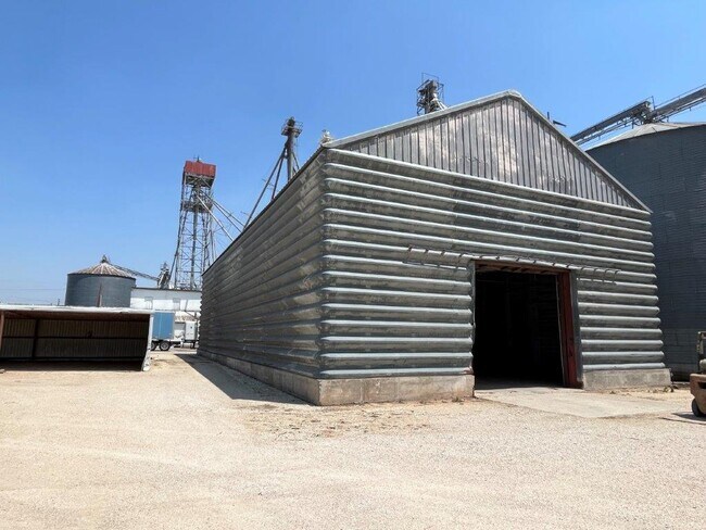
Property Detail
401 W Dale St
R000012165
LOT: EXC: HWY ROW PT OF 7-10 BLK: ALL 1 & ALLEY SUBD: DALE WEST PART OF MILL TRACT
Industrialgeneral
RUNNELS
2025
Texas
2025
2.11 AC
950200
Texas West Area
6,512 SF
Other Market Areas
NEARBY LISTINGS FOR SALE OR LEASE
-
-
View all Winters listings for sale on LoopNet.com
DEMOGRAPHICS near 401 W Dale St
1 mile
3 mile
5 mile
2025 Total Population
2,151
2,580
2,746
2030 Population
2,143
2,574
2,741
Pop Growth 2025-2030
(0.37%)
(0.23%)
(0.18%)
Average Age
42
42
43
2025 Total Households
868
1,045
1,117
HH Growth 2025-2030
(0.35%)
(0.19%)
(0.18%)
Median Household Inc
$45,435
$48,266
$49,415
Avg Household Size
2.50
2.40
2.40
2025 Avg HH Vehicles
2.00
2.00
2.00
Median Home Value
$70,134
$77,133
$79,920
Median Year Built
1957
1959
1959
Nearby Places
Map Layers
Map Styles
 Street
 Aerial
Layers
 Traffic
 Biking
Places
Listings with unknown addresses are not visible on the map
- Restaurants
- Banks
- Shops
- Fitness
- Groceries
SALE & LEASE HISTORY
LISTING DATE
SALE/LEASE

May 10, 2022
For Sale
Nearby Properties
Address
Land Use
TOTAL SIZE
Lot Size
Zoning
Address
Land Use
TOTAL SIZE
Lot Size
Zoning
99,697 SF
5.48 AC
Address
Land Use
TOTAL SIZE
Lot Size
Zoning
177,876 SF
7 AC
Address
Land Use
TOTAL SIZE
Lot Size
Zoning
19,192 SF
Address
Land Use
TOTAL SIZE
Lot Size
Zoning
23,602 SF
1.65 AC
Address
Land Use
TOTAL SIZE
Lot Size
Zoning
16,305 SF
0.79 AC
Address
Land Use
TOTAL SIZE
Lot Size
Zoning
17,702 SF
0.96 AC
Address
Land Use
TOTAL SIZE
Lot Size
Zoning
20,247 SF
1.76 AC
Address
Land Use
TOTAL SIZE
Lot Size
Zoning
10,976 SF
1.71 AC
Address
Land Use
TOTAL SIZE
Lot Size
Zoning
13,125 SF
Address
Land Use
TOTAL SIZE
Lot Size
Zoning
20,575 SF
3.11 AC
Address
Land Use
TOTAL SIZE
Lot Size
Zoning
44,785 SF
0.82 AC
Address
Land Use
TOTAL SIZE
Lot Size
Zoning
23,556 SF
0.82 AC
Address
Land Use
TOTAL SIZE
Lot Size
Zoning
14,972 SF
1.05 AC
Address
Land Use
TOTAL SIZE
Lot Size
Zoning
14,144 SF
Address
Land Use
TOTAL SIZE
Lot Size
Zoning
9,261 SF
3.90 AC
Address
Land Use
TOTAL SIZE
Lot Size
Zoning
27,859 SF
1.23 AC
Address
Land Use
TOTAL SIZE
Lot Size
Zoning
35,144 SF
Address
Land Use
TOTAL SIZE
Lot Size
Zoning
260,955 SF
8.30 AC
Address
Land Use
TOTAL SIZE
Lot Size
Zoning
14,746 SF
Address
Land Use
TOTAL SIZE
Lot Size
Zoning
10,759 SF
122.69 AC
Address
Land Use
TOTAL SIZE
Lot Size
Zoning
8,291 SF
1.07 AC
Address
Land Use
TOTAL SIZE
Lot Size
Zoning
8,312 SF
0.68 AC
Address
Land Use
TOTAL SIZE
Lot Size
Zoning
9,844 SF
0.86 AC
Address
Land Use
TOTAL SIZE
Lot Size
Zoning
8,712 SF
0.95 AC
Address
Land Use
TOTAL SIZE
Lot Size
Zoning
17,524 SF
1.02 AC
Address
Land Use
TOTAL SIZE
Lot Size
Zoning
11,193 SF
0.30 AC
Address
Land Use
TOTAL SIZE
Lot Size
Zoning
8,912 SF
4 AC
Address
Land Use
TOTAL SIZE
Lot Size
Zoning
8,266 SF
Address
Land Use
TOTAL SIZE
Lot Size
Zoning
8,264 SF
1.34 AC
Address
Land Use
TOTAL SIZE
Lot Size
Zoning
9,816 SF
1.91 AC
The World's #1 Commercial Real Estate Marketplace
Connect with us
© 2026 CoStar Group
The information above has been obtained from sources believed reliable. While we do not doubt its accuracy we have not verified it and make no guarantee, warranty or representation about it. It is your responsibility to independently confirm its accuracy and completeness. Any projections, opinions, assumptions, or estimates used are for example only and do not represent the current or future performance of the property. The value of this transaction to you depends on tax and other factors which should be evaluated by your tax, financial, and legal advisors. You and your advisors should conduct a careful, independent investigation of the property to determine to your satisfaction the suitability of the property for your needs.