Property Record
401 W Lerdo Hwy, Shafter, CA 93263
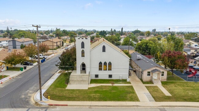

This Property Is For Sale
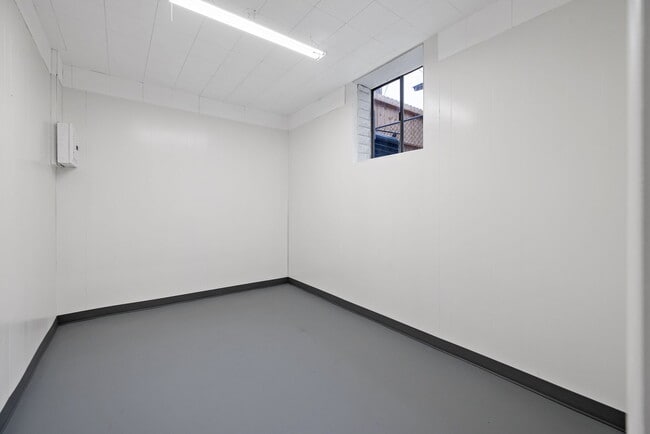
Property Detail
401 W Lerdo Hwy
026-201-08-00-7
SECTION 16 , TOWNSHIP 28 , RANGE 25 , QUARTER
Religious
KERN
B and X Area of moderate flood hazard, usually the area between the limits of the 100-year and 500-year floods.
California
2024
0.39 AC
2025
NW Outlying Kern County
004102
Bakersfield
3,050 SF
Bakersfield-Delano, CA
NEARBY LISTINGS FOR SALE OR LEASE
-
-
View all Shafter listings for sale on LoopNet.com
DEMOGRAPHICS near 401 W Lerdo Hwy
1 mile
3 mile
5 mile
2025 Total Population
16,536
23,642
24,307
2030 Population
16,861
24,208
24,867
Pop Growth 2025-2030
+ 1.97%
+ 2.39%
+ 2.30%
Average Age
32
33
33
2025 Total Households
4,381
6,289
6,419
HH Growth 2025-2030
+ 2.19%
+ 2.97%
+ 2.94%
Median Household Inc
$59,644
$67,203
$67,191
Avg Household Size
3.70
3.60
3.60
2025 Avg HH Vehicles
2.00
2.00
2.00
Median Home Value
$316,071
$355,716
$356,968
Median Year Built
1990
1991
1990
Nearby Places
Map Layers
Map Styles
 Street
 Aerial
Layers
 Traffic
 Biking
Places
Listings with unknown addresses are not visible on the map
- Restaurants
- Banks
- Shops
- Fitness
- Groceries
PUBLIC TRANSPORTATION
AIRPORT
Meadows Field
Drive
Walk
Distance
Meadows Field
26 min
15.5 mi
Freight Ports
The Port of Hueneme
Drive
Walk
Distance
The Port of Hueneme
173 min
140.2 mi
Nearby Properties
Address
Land Use
TOTAL SIZE
Lot Size
Zoning
Address
Land Use
TOTAL SIZE
Lot Size
Zoning
8,340 SF
8.34 AC
R1
Address
Land Use
TOTAL SIZE
Lot Size
Zoning
92,011 SF
8.32 AC
Address
Land Use
TOTAL SIZE
Lot Size
Zoning
75,675 SF
8.43 AC
A
Address
Land Use
TOTAL SIZE
Lot Size
Zoning
1,415 SF
38.64 AC
A
Address
Land Use
TOTAL SIZE
Lot Size
Zoning
3,119 SF
153.42 AC
BP
Address
Land Use
TOTAL SIZE
Lot Size
Zoning
75.88 AC
Address
Land Use
TOTAL SIZE
Lot Size
Zoning
140.40 AC
A
Address
Land Use
TOTAL SIZE
Lot Size
Zoning
17,588 SF
1.66 AC
GC
Address
Land Use
TOTAL SIZE
Lot Size
Zoning
38.18 AC
A
Address
Land Use
TOTAL SIZE
Lot Size
Zoning
Address
Land Use
TOTAL SIZE
Lot Size
Zoning
14.49 AC
A
Address
Land Use
TOTAL SIZE
Lot Size
Zoning
7,437 SF
0.75 AC
GC
Address
Land Use
TOTAL SIZE
Lot Size
Zoning
318.18 AC
A
Address
Land Use
TOTAL SIZE
Lot Size
Zoning
5,200 SF
14.31 AC
Address
Land Use
TOTAL SIZE
Lot Size
Zoning
5,250 SF
38.18 AC
A
Address
Land Use
TOTAL SIZE
Lot Size
Zoning
21,357 SF
1.38 AC
R1
Address
Land Use
TOTAL SIZE
Lot Size
Zoning
9,720 SF
7.87 AC
M-2
Address
Land Use
TOTAL SIZE
Lot Size
Zoning
9.14 AC
A
Address
Land Use
TOTAL SIZE
Lot Size
Zoning
159 AC
A
Address
Land Use
TOTAL SIZE
Lot Size
Zoning
1,200 SF
0.17 AC
R-2
Address
Land Use
TOTAL SIZE
Lot Size
Zoning
10,715 SF
1.45 AC
Address
Land Use
TOTAL SIZE
Lot Size
Zoning
2,100 SF
0.61 AC
GC
Address
Land Use
TOTAL SIZE
Lot Size
Zoning
12,361 SF
1.24 AC
Address
Land Use
TOTAL SIZE
Lot Size
Zoning
3,872 SF
37.98 AC
M2
Address
Land Use
TOTAL SIZE
Lot Size
Zoning
147 AC
A
Address
Land Use
TOTAL SIZE
Lot Size
Zoning
7,105 SF
0.95 AC
Address
Land Use
TOTAL SIZE
Lot Size
Zoning
254.17 AC
A
Address
Land Use
TOTAL SIZE
Lot Size
Zoning
4,100 SF
7.28 AC
M
Address
Land Use
TOTAL SIZE
Lot Size
Zoning
6,050 SF
4.73 AC
Address
Land Use
TOTAL SIZE
Lot Size
Zoning
8,000 SF
0.71 AC
DC
The World's #1 Commercial Real Estate Marketplace
Connect with us
© 2026 CoStar Group
The information above has been obtained from sources believed reliable. While we do not doubt its accuracy we have not verified it and make no guarantee, warranty or representation about it. It is your responsibility to independently confirm its accuracy and completeness. Any projections, opinions, assumptions, or estimates used are for example only and do not represent the current or future performance of the property. The value of this transaction to you depends on tax and other factors which should be evaluated by your tax, financial, and legal advisors. You and your advisors should conduct a careful, independent investigation of the property to determine to your satisfaction the suitability of the property for your needs.