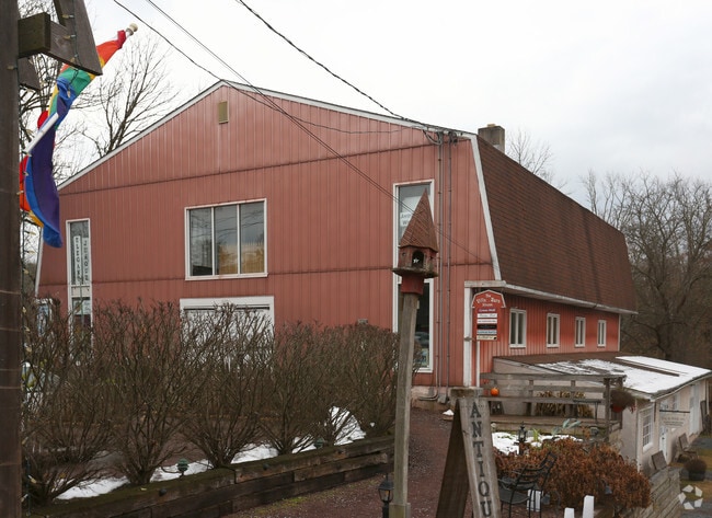
Property Record
4014 Skippack Pike, Skippack, PA 19474
Current Lease Availabilities
NEARBY LISTINGS FOR SALE OR LEASE
Property Detail
4014 Skippack Pike
51-00-03532-008
ASSESSOR BLOCK-UNIT NUMBER 16-40
Commercialnec
Montgomery
AE
Pennsylvania
42091C0232G
40
2024
1.03 AC
2025
West Montgomery County
206704
Philadelphia
14,904 SF
Philadelphia-Camden-Wilmington, PA-NJ-DE-MD
DEMOGRAPHICS near 4014 Skippack Pike
1 Mile
3 Mile
5 Mile
2024 Total Population
3,606
22,655
97,728
2029 Population
3,500
22,654
99,026
Pop Growth 2024-2029
(2.94%)
0.00%
+ 1.33%
Average Age
41
43
42
2024 Total Households
1,358
7,007
34,186
HH Growth 2024-2029
(3.02%)
0.00%
+ 1.37%
Median Household Inc
$141,315
$153,375
$125,264
Avg Household Size
2.70
2.70
2.60
2024 Avg HH Vehicles
2.00
2.00
2.00
Median Home Value
$432,036
$453,443
$420,901
Median Year Built
1990
1991
1986
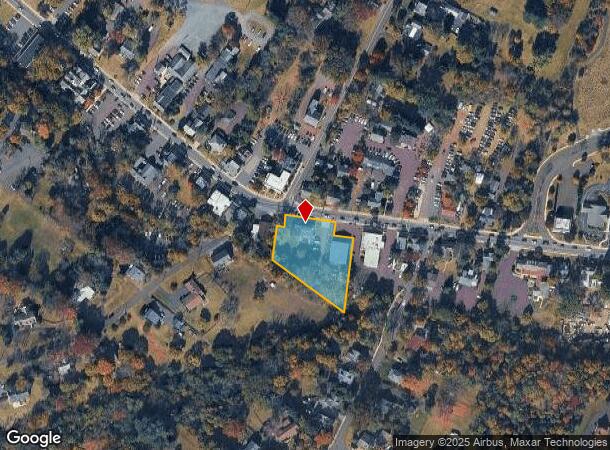
Nearby Places
Map Layers
Map Styles
 Street
 Aerial
- Restaurants
- Banks
- Shops
- Fitness
- Groceries
PUBLIC TRANSPORTATION
COMMUTER RAIL
Pennbrook (R5 - Southeastern Pennsylvania Transportation Authority Regional Rail (SEPTA Regional Rail))
DRIVE
WALK
Distance
Pennbrook (R5 - Southeastern Pennsylvania Transportation Authority Regional Rail (SEPTA Regional Rail))
15 min
8.5 mi
Lansdale (R5 - Southeastern Pennsylvania Transportation Authority Regional Rail (SEPTA Regional Rail))
DRIVE
WALK
Distance
Lansdale (R5 - Southeastern Pennsylvania Transportation Authority Regional Rail (SEPTA Regional Rail))
14 min
8.5 mi
AIRPORT
Philadelphia International
DRIVE
WALK
Distance
Philadelphia International
55 min
38.5 mi
Lehigh Valley International
DRIVE
WALK
Distance
Lehigh Valley International
56 min
41.9 mi
Freight Ports
Port of Philadelphia
DRIVE
WALK
Distance
Port of Philadelphia
42 min
25.7 mi
Nearby Properties
Address
Land Use
TOTAL SIZE
Lot Size
Zoning
Address
Land Use
TOTAL SIZE
Lot Size
Zoning
1.74 AC
IR
Address
Land Use
TOTAL SIZE
Lot Size
Zoning
720,767 SF
118.21 AC
AGR
Address
Land Use
TOTAL SIZE
Lot Size
Zoning
98,724 SF
35.50 AC
R1
Address
Land Use
TOTAL SIZE
Lot Size
Zoning
90,217 SF
19 AC
R1
Address
Land Use
TOTAL SIZE
Lot Size
Zoning
29,014 SF
13.41 AC
R5
Address
Land Use
TOTAL SIZE
Lot Size
Zoning
59,965 SF
14.20 AC
R175
Address
Land Use
TOTAL SIZE
Lot Size
Zoning
223.97 AC
R1
Address
Land Use
TOTAL SIZE
Lot Size
Zoning
28,885 SF
52.82 AC
CF-2
Address
Land Use
TOTAL SIZE
Lot Size
Zoning
48,360 SF
8.65 AC
LI
Address
Land Use
TOTAL SIZE
Lot Size
Zoning
54,704 SF
6.69 AC
LI
Address
Land Use
TOTAL SIZE
Lot Size
Zoning
24,408 SF
20.74 AC
R1
Address
Land Use
TOTAL SIZE
Lot Size
Zoning
87,190 SF
14.47 AC
LI
Address
Land Use
TOTAL SIZE
Lot Size
Zoning
6,569 SF
107 AC
IR
Address
Land Use
TOTAL SIZE
Lot Size
Zoning
70,524 SF
10.66 AC
LI
Address
Land Use
TOTAL SIZE
Lot Size
Zoning
20,730 SF
36.85 AC
AGR
Address
Land Use
TOTAL SIZE
Lot Size
Zoning
23,234 SF
0.34 AC
VC
Address
Land Use
TOTAL SIZE
Lot Size
Zoning
55,586 SF
4.50 AC
LI
Address
Land Use
TOTAL SIZE
Lot Size
Zoning
23,125 SF
3.31 AC
GC
Address
Land Use
TOTAL SIZE
Lot Size
Zoning
15,140 SF
1.92 AC
GC
Address
Land Use
TOTAL SIZE
Lot Size
Zoning
35,835 SF
9.20 AC
GC
Address
Land Use
TOTAL SIZE
Lot Size
Zoning
52,897 SF
9.77 AC
R175
Address
Land Use
TOTAL SIZE
Lot Size
Zoning
56.32 AC
R175
Address
Land Use
TOTAL SIZE
Lot Size
Zoning
68,500 SF
5.67 AC
LI
Address
Land Use
TOTAL SIZE
Lot Size
Zoning
4,460 SF
5.61 AC
LI
Address
Land Use
TOTAL SIZE
Lot Size
Zoning
20,604 SF
5.92 AC
IR
Address
Land Use
TOTAL SIZE
Lot Size
Zoning
41,027 SF
3 AC
LI
Address
Land Use
TOTAL SIZE
Lot Size
Zoning
23,760 SF
3.85 AC
GC
Address
Land Use
TOTAL SIZE
Lot Size
Zoning
24,371 SF
3.81 AC
GC
Address
Land Use
TOTAL SIZE
Lot Size
Zoning
16,237 SF
3.34 AC
VCR
Address
Land Use
TOTAL SIZE
Lot Size
Zoning
The World's #1 Commercial Real Estate Marketplace
Connect with us
© 2025 CoStar Group
The information above has been obtained from sources believed reliable. While we do not doubt its accuracy we have not verified it and make no guarantee, warranty or representation about it. It is your responsibility to independently confirm its accuracy and completeness. Any projections, opinions, assumptions, or estimates used are for example only and do not represent the current or future performance of the property. The value of this transaction to you depends on tax and other factors which should be evaluated by your tax, financial, and legal advisors. You and your advisors should conduct a careful, independent investigation of the property to determine to your satisfaction the suitability of the property for your needs.