Property Record
4010 Whitney Rd, Cheyenne, WY 82001


Property Detail
4010 Whitney Rd
Cheyenne, WY
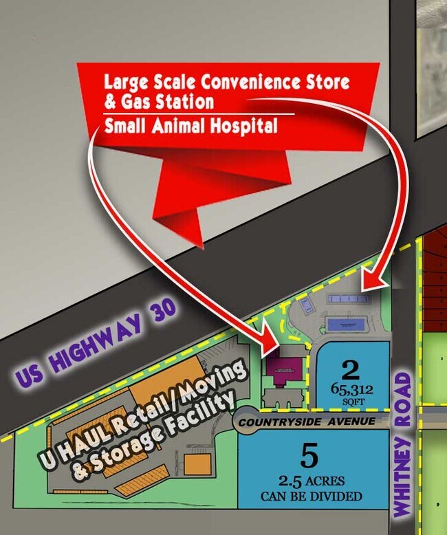
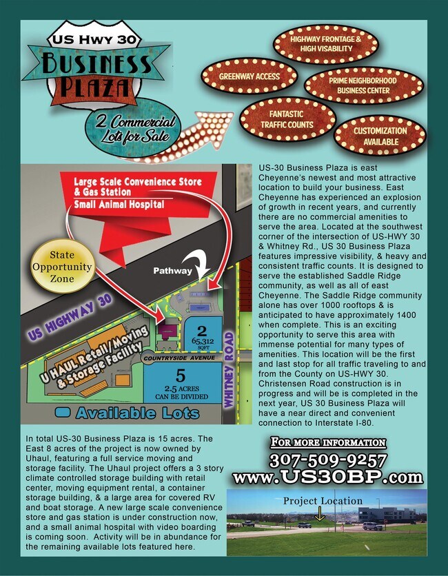
US 30 BUSINESS PLAZA: LOTS 1 AND 3, BLOCK 1
1-9000-0001-0001-0
LARAMIE
Commercialnec
Wyoming
B and X Area of moderate flood hazard, usually the area between the limits of the 100-year and 500-year floods.
1,3
2024
2.13 AC
2025
I-80 Corridor/Cheyenne
001502
Other Market Areas
4,489 SF
NEARBY LISTINGS FOR SALE OR LEASE
DEMOGRAPHICS near 4010 Whitney Rd
1 mile
3 mile
5 mile
2025 Total Population
6,246
31,320
60,300
2030 Population
6,394
31,433
60,425
Pop Growth 2025-2030
+ 2.37%
+ 0.36%
+ 0.21%
Average Age
37
40
41
2025 Total Households
2,335
12,820
25,652
HH Growth 2025-2030
+ 2.40%
+ 0.55%
+ 0.37%
Median Household Inc
$88,023
$80,408
$74,727
Avg Household Size
2.70
2.40
2.30
2025 Avg HH Vehicles
2.00
2.00
2.00
Median Home Value
$387,177
$336,911
$326,838
Median Year Built
2009
1985
1978
Nearby Places
Map Layers
Map Styles
 Street
 Aerial
Transit
 Traffic
 Biking
Places
Listings with unknown addresses are not visible on the map
- Restaurants
- Banks
- Shops
- Fitness
- Groceries
SALE & LEASE HISTORY
LISTING DATE
SALE/LEASE

Sep 24, 2016
For Sale
Feb 18, 2019
For Sale
Nearby Properties
Address
Land Use
TOTAL SIZE
Lot Size
Zoning
Address
Land Use
TOTAL SIZE
Lot Size
Zoning
1,120,931 SF
149.20 AC
Address
Land Use
TOTAL SIZE
Lot Size
Zoning
639,397 SF
67.52 AC
Address
Land Use
TOTAL SIZE
Lot Size
Zoning
243,960 SF
60.52 AC
Address
Land Use
TOTAL SIZE
Lot Size
Zoning
91,021 SF
7.40 AC
Address
Land Use
TOTAL SIZE
Lot Size
Zoning
210,717 SF
18.28 AC
Address
Land Use
TOTAL SIZE
Lot Size
Zoning
156,244 SF
4.75 AC
Address
Land Use
TOTAL SIZE
Lot Size
Zoning
180,600 SF
13.72 AC
HI
Address
Land Use
TOTAL SIZE
Lot Size
Zoning
136,488 SF
13.38 AC
CB
Address
Land Use
TOTAL SIZE
Lot Size
Zoning
114,342 SF
59.95 AC
HI
Address
Land Use
TOTAL SIZE
Lot Size
Zoning
109,096 SF
4.03 AC
MR2
Address
Land Use
TOTAL SIZE
Lot Size
Zoning
193,881 SF
21.36 AC
CB
Address
Land Use
TOTAL SIZE
Lot Size
Zoning
37,714 SF
4.29 AC
Address
Land Use
TOTAL SIZE
Lot Size
Zoning
88,107 SF
10.73 AC
Address
Land Use
TOTAL SIZE
Lot Size
Zoning
96,088 SF
8.34 AC
Address
Land Use
TOTAL SIZE
Lot Size
Zoning
73,266 SF
8.08 AC
Address
Land Use
TOTAL SIZE
Lot Size
Zoning
59,223 SF
9.91 AC
HI
Address
Land Use
TOTAL SIZE
Lot Size
Zoning
54,666 SF
3.69 AC
MR2
Address
Land Use
TOTAL SIZE
Lot Size
Zoning
135,125 SF
8.87 AC
Address
Land Use
TOTAL SIZE
Lot Size
Zoning
174,000 SF
11.57 AC
MR2
Address
Land Use
TOTAL SIZE
Lot Size
Zoning
82,494 SF
17.27 AC
Address
Land Use
TOTAL SIZE
Lot Size
Zoning
46,705 SF
14.11 AC
HI
Address
Land Use
TOTAL SIZE
Lot Size
Zoning
33,080 SF
8.91 AC
Address
Land Use
TOTAL SIZE
Lot Size
Zoning
131,194 SF
17.67 AC
MR2
Address
Land Use
TOTAL SIZE
Lot Size
Zoning
48,566 SF
3.96 AC
MR2
Address
Land Use
TOTAL SIZE
Lot Size
Zoning
58,373 SF
0.85 AC
CB
Address
Land Use
TOTAL SIZE
Lot Size
Zoning
104,331 SF
5.56 AC
HR1
Address
Land Use
TOTAL SIZE
Lot Size
Zoning
114,503 SF
11.43 AC
MR2
Address
Land Use
TOTAL SIZE
Lot Size
Zoning
137,934 SF
15.52 AC
HI
Address
Land Use
TOTAL SIZE
Lot Size
Zoning
98,923 SF
14.06 AC
Address
Land Use
TOTAL SIZE
Lot Size
Zoning
104,870 SF
6.44 AC
The World's #1 Commercial Real Estate Marketplace
Connect with us
© 2026 CoStar Group
The information above has been obtained from sources believed reliable. While we do not doubt its accuracy we have not verified it and make no guarantee, warranty or representation about it. It is your responsibility to independently confirm its accuracy and completeness. Any projections, opinions, assumptions, or estimates used are for example only and do not represent the current or future performance of the property. The value of this transaction to you depends on tax and other factors which should be evaluated by your tax, financial, and legal advisors. You and your advisors should conduct a careful, independent investigation of the property to determine to your satisfaction the suitability of the property for your needs.