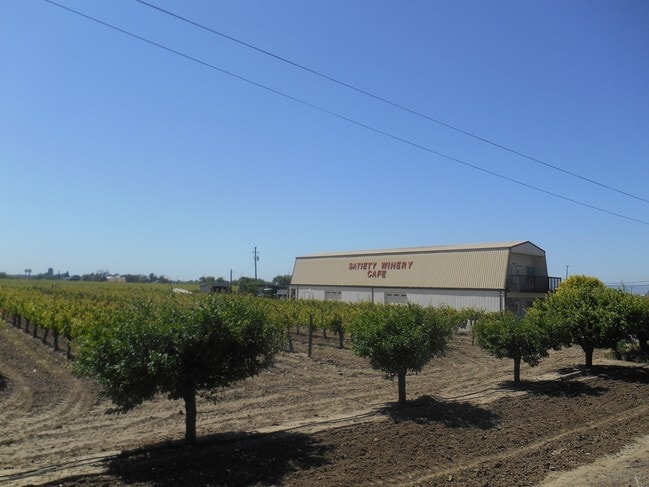
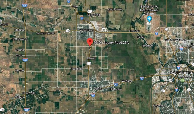
Property Record
40101 Cr 25A, Davis, CA


Property Detail
40101 Cr 25A
041-020-037-000
2716 PCL B MB 3 PG 98
Farms
YOLO
A1
California
B and X Area of moderate flood hazard, usually the area between the limits of the 100-year and 500-year floods.
28.98 AC
2024
Davis/Woodland
2025
Sacramento
011208
Sacramento-Roseville-Folsom, CA
NEARBY LISTINGS FOR SALE OR LEASE
DEMOGRAPHICS near 40101 Cr 25A
1 mile
3 mile
5 mile
2025 Total Population
59
47,105
67,081
2030 Population
60
48,021
68,228
Pop Growth 2025-2030
+ 1.69%
+ 1.94%
+ 1.71%
Average Age
38
39
39
2025 Total Households
16
15,885
22,912
HH Growth 2025-2030
+ 6.25%
+ 2.05%
+ 1.82%
Median Household Inc
$103,125
$104,949
$97,926
Avg Household Size
3.10
2.90
2.80
2025 Avg HH Vehicles
2.00
2.00
2.00
Median Home Value
$541,667
$602,251
$588,575
Median Year Built
1978
1983
1981
Nearby Places
Map Layers
Map Styles
 Street
 Aerial
Layers
 Traffic
 Biking
Places
Listings with unknown addresses are not visible on the map
- Restaurants
- Banks
- Shops
- Fitness
- Groceries
PUBLIC TRANSPORTATION
COMMUTER RAIL
Davis (Capitol Corridor - Capitol Corridor Joint Powers Authority)
Drive
Walk
Distance
Davis (Capitol Corridor - Capitol Corridor Joint Powers Authority)
14 min
8.7 mi
AIRPORT
Sacramento International
Drive
Walk
Distance
Sacramento International
20 min
13.4 mi
Freight Ports
Port of Stockton
Drive
Walk
Distance
Port of Stockton
78 min
66.9 mi
SALE & LEASE HISTORY
LISTING DATE
SALE/LEASE

May 31, 2018
For Sale
Jun 27, 2017
For Sale
Feb 20, 2020
For Sale
Nearby Properties
Address
Land Use
TOTAL SIZE
Lot Size
Zoning
Address
Land Use
TOTAL SIZE
Lot Size
Zoning
23.92 AC
M2
Address
Land Use
TOTAL SIZE
Lot Size
Zoning
180,816 SF
0.17 AC
R-M
Address
Land Use
TOTAL SIZE
Lot Size
Zoning
12,032 SF
0.12 AC
R3
Address
Land Use
TOTAL SIZE
Lot Size
Zoning
348,386 SF
17.67 AC
RM
Address
Land Use
TOTAL SIZE
Lot Size
Zoning
150,269 SF
6.95 AC
R-M
Address
Land Use
TOTAL SIZE
Lot Size
Zoning
8.83 AC
A1
Address
Land Use
TOTAL SIZE
Lot Size
Zoning
67,104 SF
0.32 AC
R25
Address
Land Use
TOTAL SIZE
Lot Size
Zoning
4.46 AC
C-3
Address
Land Use
TOTAL SIZE
Lot Size
Zoning
427,073 SF
24.51 AC
I
Address
Land Use
TOTAL SIZE
Lot Size
Zoning
145,694 SF
9.26 AC
MDR20
Address
Land Use
TOTAL SIZE
Lot Size
Zoning
69 AC
AP
Address
Land Use
TOTAL SIZE
Lot Size
Zoning
24,500 SF
7.42 AC
EOZ
Address
Land Use
TOTAL SIZE
Lot Size
Zoning
26.48 AC
A1
Address
Land Use
TOTAL SIZE
Lot Size
Zoning
0.16 AC
PUD
Address
Land Use
TOTAL SIZE
Lot Size
Zoning
71,493 SF
1.98 AC
C3
Address
Land Use
TOTAL SIZE
Lot Size
Zoning
94,860 SF
11.70 AC
EOZ-I/PD
Address
Land Use
TOTAL SIZE
Lot Size
Zoning
128,755 SF
13.61 AC
C2
Address
Land Use
TOTAL SIZE
Lot Size
Zoning
90,570 SF
8.08 AC
C2
Address
Land Use
TOTAL SIZE
Lot Size
Zoning
64,896 SF
4.39 AC
R-M
Address
Land Use
TOTAL SIZE
Lot Size
Zoning
150.36 AC
A-P
Address
Land Use
TOTAL SIZE
Lot Size
Zoning
0.55 AC
R25
Address
Land Use
TOTAL SIZE
Lot Size
Zoning
126,392 SF
0.17 AC
C2
Address
Land Use
TOTAL SIZE
Lot Size
Zoning
58,050 SF
6.55 AC
R-M
Address
Land Use
TOTAL SIZE
Lot Size
Zoning
51,320 SF
4.68 AC
Address
Land Use
TOTAL SIZE
Lot Size
Zoning
62,208 SF
3.07 AC
R-M
Address
Land Use
TOTAL SIZE
Lot Size
Zoning
46,689 SF
2.73 AC
R15
Address
Land Use
TOTAL SIZE
Lot Size
Zoning
71,280 SF
0.23 AC
R-M
Address
Land Use
TOTAL SIZE
Lot Size
Zoning
58,658 SF
5.62 AC
C1
Address
Land Use
TOTAL SIZE
Lot Size
Zoning
47,385 SF
8.55 AC
I
Address
Land Use
TOTAL SIZE
Lot Size
Zoning
263,328 SF
13 AC
I
The World's #1 Commercial Real Estate Marketplace
Connect with us
© 2026 CoStar Group
The information above has been obtained from sources believed reliable. While we do not doubt its accuracy we have not verified it and make no guarantee, warranty or representation about it. It is your responsibility to independently confirm its accuracy and completeness. Any projections, opinions, assumptions, or estimates used are for example only and do not represent the current or future performance of the property. The value of this transaction to you depends on tax and other factors which should be evaluated by your tax, financial, and legal advisors. You and your advisors should conduct a careful, independent investigation of the property to determine to your satisfaction the suitability of the property for your needs.