Property Record
4012 Highway 74 E, Wingate, NC 28174
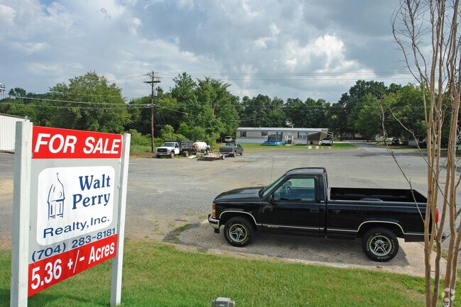

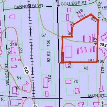

Property Detail
4012 Highway 74 E
09-022-088
#2-#4 & #12-#21 EVANS PB2 PG149
Storebuilding
UNION
B-1 WINGAT
North Carolina
B and X Area of moderate flood hazard, usually the area between the limits of the 100-year and 500-year floods.
5.36 AC
2025
Union County
2025
Charlotte
020203
Charlotte-Concord-Gastonia, NC-SC
NEARBY LISTINGS FOR SALE OR LEASE
DEMOGRAPHICS near 4012 Highway 74 E
1 mile
3 mile
5 mile
2025 Total Population
3,843
8,953
23,498
2030 Population
4,066
9,617
25,531
Pop Growth 2025-2030
+ 5.80%
+ 7.42%
+ 8.65%
Average Age
33
36
38
2025 Total Households
858
2,505
7,535
HH Growth 2025-2030
+ 6.99%
+ 8.26%
+ 9.06%
Median Household Inc
$54,444
$60,166
$68,059
Avg Household Size
2.70
2.70
2.70
2025 Avg HH Vehicles
2.00
2.00
2.00
Median Home Value
$340,789
$298,709
$353,915
Median Year Built
1989
1989
1987
Nearby Places
Map Layers
Map Styles
 Street
 Aerial
Transit
 Traffic
 Biking
Places
Listings with unknown addresses are not visible on the map
- Restaurants
- Banks
- Shops
- Fitness
- Groceries
SALE & LEASE HISTORY
LISTING DATE
SALE/LEASE

Sep 24, 2016
For Sale
Nearby Properties
Address
Land Use
TOTAL SIZE
Lot Size
Zoning
Address
Land Use
TOTAL SIZE
Lot Size
Zoning
138,123 SF
113.13 AC
B-1 WINGAT
Address
Land Use
TOTAL SIZE
Lot Size
Zoning
68,870 SF
33.25 AC
HC WINGATE
Address
Land Use
TOTAL SIZE
Lot Size
Zoning
68,258 SF
3.39 AC
R-20 WINGA
Address
Land Use
TOTAL SIZE
Lot Size
Zoning
138,165 SF
135.17 AC
HC UNION C
Address
Land Use
TOTAL SIZE
Lot Size
Zoning
79,493 SF
32.65 AC
RA-20 UNIO
Address
Land Use
TOTAL SIZE
Lot Size
Zoning
2,873 SF
55.59 AC
G-I MONROE
Address
Land Use
TOTAL SIZE
Lot Size
Zoning
28,468 SF
3.51 AC
B-1 WINGAT
Address
Land Use
TOTAL SIZE
Lot Size
Zoning
214,256 SF
16.68 AC
G-I MONROE
Address
Land Use
TOTAL SIZE
Lot Size
Zoning
80,000 SF
10.19 AC
G-I MONROE
Address
Land Use
TOTAL SIZE
Lot Size
Zoning
28.93 AC
Address
Land Use
TOTAL SIZE
Lot Size
Zoning
40,297 SF
7.95 AC
CD MONROE
Address
Land Use
TOTAL SIZE
Lot Size
Zoning
64,743 SF
13.82 AC
R-20 WINGA
Address
Land Use
TOTAL SIZE
Lot Size
Zoning
810 SF
9.55 AC
CD MONROE
Address
Land Use
TOTAL SIZE
Lot Size
Zoning
139,544 SF
17.21 AC
G-I MONROE
Address
Land Use
TOTAL SIZE
Lot Size
Zoning
164.35 AC
R-20 MONRO
Address
Land Use
TOTAL SIZE
Lot Size
Zoning
15,103 SF
2.01 AC
B-1 WINGAT
Address
Land Use
TOTAL SIZE
Lot Size
Zoning
98,000 SF
14.92 AC
G-I MONROE
Address
Land Use
TOTAL SIZE
Lot Size
Zoning
28 AC
IND MARSHV
Address
Land Use
TOTAL SIZE
Lot Size
Zoning
4,252 SF
2.60 AC
R-6 WINGAT
Address
Land Use
TOTAL SIZE
Lot Size
Zoning
28,512 SF
13.74 AC
B-1 WINGAT
Address
Land Use
TOTAL SIZE
Lot Size
Zoning
26,016 SF
5.11 AC
GB MONROE
Address
Land Use
TOTAL SIZE
Lot Size
Zoning
88,895 SF
30.04 AC
G-I MONROE
Address
Land Use
TOTAL SIZE
Lot Size
Zoning
64.18 AC
CD MONROE
Address
Land Use
TOTAL SIZE
Lot Size
Zoning
72,000 SF
9.02 AC
G-I MONROE
Address
Land Use
TOTAL SIZE
Lot Size
Zoning
10.71 AC
Address
Land Use
TOTAL SIZE
Lot Size
Zoning
288 SF
6.24 AC
R-6 WINGAT
Address
Land Use
TOTAL SIZE
Lot Size
Zoning
59,738 SF
21.63 AC
G-I MONROE
Address
Land Use
TOTAL SIZE
Lot Size
Zoning
21,804 SF
0.48 AC
R-20 WINGA
Address
Land Use
TOTAL SIZE
Lot Size
Zoning
21,804 SF
0.92 AC
R-6 WINGAT
Address
Land Use
TOTAL SIZE
Lot Size
Zoning
17,304 SF
0.61 AC
B-6 WINGAT
The World's #1 Commercial Real Estate Marketplace
Connect with us
© 2026 CoStar Group
The information above has been obtained from sources believed reliable. While we do not doubt its accuracy we have not verified it and make no guarantee, warranty or representation about it. It is your responsibility to independently confirm its accuracy and completeness. Any projections, opinions, assumptions, or estimates used are for example only and do not represent the current or future performance of the property. The value of this transaction to you depends on tax and other factors which should be evaluated by your tax, financial, and legal advisors. You and your advisors should conduct a careful, independent investigation of the property to determine to your satisfaction the suitability of the property for your needs.