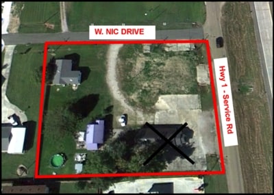
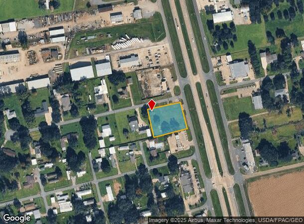
Property Record
4013 W Nic Dr, Addis, LA 70710
NEARBY LISTINGS FOR SALE OR LEASE
-
-
View all Addis listings for sale on LoopNet.com
Property Detail
4013 W Nic Dr
Baton Rouge, LA
West Missouri Bend
014830002100
LOT 15 WEST MISSOURI BEND SD & ABANDON 7.5' RIGHT OF WAY 48C-21 CB138 E191 CB548 P397 (MB2 E64, MB4 E305)
Commercialacreage
W Baton Rouge
X
Louisiana
22121C0185D
15
2024
0.96 AC
2024
West Baton Rouge
020401
Baton Rouge
639 SF
DEMOGRAPHICS near 4013 W Nic Dr
1 mile
3 mile
5 mile
2024 Total Population
3,774
12,531
22,063
2029 Population
4,103
13,471
22,965
Pop Growth 2024-2029
+ 8.72%
+ 7.50%
+ 4.09%
Average Age
35
36
37
2024 Total Households
1,371
4,632
8,428
HH Growth 2024-2029
+ 8.68%
+ 7.38%
+ 3.88%
Median Household Inc
$81,747
$83,934
$74,847
Avg Household Size
2.70
2.70
2.60
2024 Avg HH Vehicles
2.00
2.00
2.00
Median Home Value
$213,542
$227,790
$235,662
Median Year Built
2006
2005
1997
Nearby Places
Map Layers
Map Styles
 Street
 Aerial
Transit
 Traffic
 Biking
Places
Listings with unknown addresses are not visible on the map
- Restaurants
- Banks
- Shops
- Fitness
- Groceries
PUBLIC TRANSPORTATION
AIRPORT
Baton Rouge Metro Ryan Field
Drive
Walk
Distance
Baton Rouge Metro Ryan Field
25 min
16.6 mi
Freight Ports
Port of Greater Baton Rouge
Drive
Walk
Distance
Port of Greater Baton Rouge
15 min
7.7 mi
Nearby Properties
Address
Land Use
TOTAL SIZE
Lot Size
Zoning
Address
Land Use
TOTAL SIZE
Lot Size
Zoning
Address
Land Use
TOTAL SIZE
Lot Size
Zoning
16.16 AC
Address
Land Use
TOTAL SIZE
Lot Size
Zoning
3,928 SF
7.74 AC
Address
Land Use
TOTAL SIZE
Lot Size
Zoning
Address
Land Use
TOTAL SIZE
Lot Size
Zoning
Address
Land Use
TOTAL SIZE
Lot Size
Zoning
Address
Land Use
TOTAL SIZE
Lot Size
Zoning
2.90 AC
Address
Land Use
TOTAL SIZE
Lot Size
Zoning
Address
Land Use
TOTAL SIZE
Lot Size
Zoning
3.09 AC
Address
Land Use
TOTAL SIZE
Lot Size
Zoning
178.69 AC
Address
Land Use
TOTAL SIZE
Lot Size
Zoning
39,300 SF
4.55 AC
Address
Land Use
TOTAL SIZE
Lot Size
Zoning
Address
Land Use
TOTAL SIZE
Lot Size
Zoning
2.46 AC
Address
Land Use
TOTAL SIZE
Lot Size
Zoning
Address
Land Use
TOTAL SIZE
Lot Size
Zoning
Address
Land Use
TOTAL SIZE
Lot Size
Zoning
5.04 AC
Address
Land Use
TOTAL SIZE
Lot Size
Zoning
98.50 AC
Address
Land Use
TOTAL SIZE
Lot Size
Zoning
2,611 SF
27 AC
Address
Land Use
TOTAL SIZE
Lot Size
Zoning
1.60 AC
Address
Land Use
TOTAL SIZE
Lot Size
Zoning
2.49 AC
Address
Land Use
TOTAL SIZE
Lot Size
Zoning
24,737 SF
2 AC
Address
Land Use
TOTAL SIZE
Lot Size
Zoning
3.61 AC
Address
Land Use
TOTAL SIZE
Lot Size
Zoning
2,096 SF
2.01 AC
Address
Land Use
TOTAL SIZE
Lot Size
Zoning
168,550 SF
3.45 AC
Address
Land Use
TOTAL SIZE
Lot Size
Zoning
2.34 AC
Address
Land Use
TOTAL SIZE
Lot Size
Zoning
1.51 AC
Address
Land Use
TOTAL SIZE
Lot Size
Zoning
221.92 AC
Address
Land Use
TOTAL SIZE
Lot Size
Zoning
38,800 SF
3.92 AC
Address
Land Use
TOTAL SIZE
Lot Size
Zoning
3,544 SF
1.03 AC
The World's #1 Commercial Real Estate Marketplace
Connect with us
© 2026 CoStar Group
The information above has been obtained from sources believed reliable. While we do not doubt its accuracy we have not verified it and make no guarantee, warranty or representation about it. It is your responsibility to independently confirm its accuracy and completeness. Any projections, opinions, assumptions, or estimates used are for example only and do not represent the current or future performance of the property. The value of this transaction to you depends on tax and other factors which should be evaluated by your tax, financial, and legal advisors. You and your advisors should conduct a careful, independent investigation of the property to determine to your satisfaction the suitability of the property for your needs.