Property Record
4020 Plainfield Ave Ne, Grand Rapids, MI 49525

NEARBY LISTINGS FOR SALE OR LEASE
Property Detail
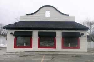
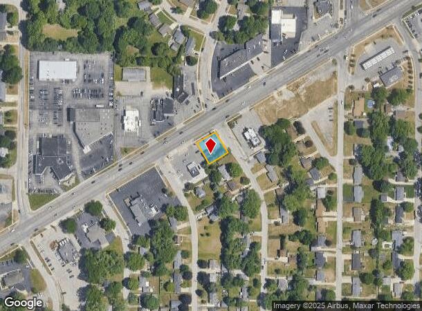
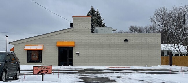
4020 Plainfield Ave Ne
Grand Rapids-Wyoming, MI
Orlando Park
41-10-33-254-006
LOTS 296 & 297 * ORLANDO PARK
Commercialnec
Kent
X
Michigan
26081C0311D
296-297
2024
0.20 AC
2025
Northeast Grand Rapids
011302
West Michigan
DEMOGRAPHICS near 4020 Plainfield Ave Ne
1 Mile
3 Mile
5 Mile
2024 Total Population
7,864
45,941
117,068
2029 Population
7,972
46,389
117,867
Pop Growth 2024-2029
+ 1.37%
+ 0.98%
+ 0.68%
Average Age
40
41
39
2024 Total Households
3,190
18,776
47,970
HH Growth 2024-2029
+ 1.38%
+ 0.92%
+ 0.66%
Median Household Inc
$77,578
$77,239
$70,302
Avg Household Size
2.40
2.40
2.40
2024 Avg HH Vehicles
2.00
2.00
2.00
Median Home Value
$233,687
$252,631
$246,137
Median Year Built
1970
1976
1972
Nearby Places
Map Layers
Map Styles
 Street
 Aerial
- Restaurants
- Banks
- Shops
- Fitness
- Groceries
PUBLIC TRANSPORTATION
COMMUTER RAIL
Grand Rapids Vernon J. Ehlers Station (Pere Marquette - Amtrak)
DRIVE
WALK
Distance
Grand Rapids Vernon J. Ehlers Station (Pere Marquette - Amtrak)
11 min
8.4 mi
AIRPORT
Gerald R Ford International
DRIVE
WALK
Distance
Gerald R Ford International
25 min
16.8 mi
Freight Ports
Port Milwaukee
DRIVE
WALK
Distance
Port Milwaukee
314 min
269.6 mi
SALE & LEASE HISTORY
LISTING DATE
SALE/LEASE

Feb 16, 2021
For Sale
Nearby Properties
Address
Land Use
TOTAL SIZE
Lot Size
Zoning
Address
Land Use
TOTAL SIZE
Lot Size
Zoning
494,398 SF
R-PUD
Address
Land Use
TOTAL SIZE
Lot Size
Zoning
25.41 AC
Address
Land Use
TOTAL SIZE
Lot Size
Zoning
257,381 SF
7.08 AC
SD-PRD
Address
Land Use
TOTAL SIZE
Lot Size
Zoning
112,764 SF
17.29 AC
SD-PRD
Address
Land Use
TOTAL SIZE
Lot Size
Zoning
18.07 AC
MON-LDR
Address
Land Use
TOTAL SIZE
Lot Size
Zoning
21.77 AC
MCN-MDR
Address
Land Use
TOTAL SIZE
Lot Size
Zoning
47,370 SF
8.18 AC
MON-LDR
Address
Land Use
TOTAL SIZE
Lot Size
Zoning
Address
Land Use
TOTAL SIZE
Lot Size
Zoning
Address
Land Use
TOTAL SIZE
Lot Size
Zoning
24.96 AC
MCN-MDR
Address
Land Use
TOTAL SIZE
Lot Size
Zoning
247,954 SF
40.84 AC
SD-PRD
Address
Land Use
TOTAL SIZE
Lot Size
Zoning
158,449 SF
14.33 AC
MCN-MDR
Address
Land Use
TOTAL SIZE
Lot Size
Zoning
Address
Land Use
TOTAL SIZE
Lot Size
Zoning
145,127 SF
18.52 AC
SD-PRD
Address
Land Use
TOTAL SIZE
Lot Size
Zoning
16.34 AC
Address
Land Use
TOTAL SIZE
Lot Size
Zoning
Address
Land Use
TOTAL SIZE
Lot Size
Zoning
13.26 AC
MON-MDR
Address
Land Use
TOTAL SIZE
Lot Size
Zoning
Address
Land Use
TOTAL SIZE
Lot Size
Zoning
138,864 SF
34.91 AC
R-1
Address
Land Use
TOTAL SIZE
Lot Size
Zoning
Address
Land Use
TOTAL SIZE
Lot Size
Zoning
16.29 AC
MCN-MDR
Address
Land Use
TOTAL SIZE
Lot Size
Zoning
14.36 AC
MON-MDR
Address
Land Use
TOTAL SIZE
Lot Size
Zoning
97,894 SF
5.90 AC
MCN-LDR
Address
Land Use
TOTAL SIZE
Lot Size
Zoning
8.43 AC
Address
Land Use
TOTAL SIZE
Lot Size
Zoning
70,130 SF
2.99 AC
SD-PRD
Address
Land Use
TOTAL SIZE
Lot Size
Zoning
Address
Land Use
TOTAL SIZE
Lot Size
Zoning
8 AC
MON-MDR
Address
Land Use
TOTAL SIZE
Lot Size
Zoning
8.68 AC
MON-MDR
Address
Land Use
TOTAL SIZE
Lot Size
Zoning
Address
Land Use
TOTAL SIZE
Lot Size
Zoning
The World's #1 Commercial Real Estate Marketplace
Connect with us
© 2025 CoStar Group
The information above has been obtained from sources believed reliable. While we do not doubt its accuracy we have not verified it and make no guarantee, warranty or representation about it. It is your responsibility to independently confirm its accuracy and completeness. Any projections, opinions, assumptions, or estimates used are for example only and do not represent the current or future performance of the property. The value of this transaction to you depends on tax and other factors which should be evaluated by your tax, financial, and legal advisors. You and your advisors should conduct a careful, independent investigation of the property to determine to your satisfaction the suitability of the property for your needs.