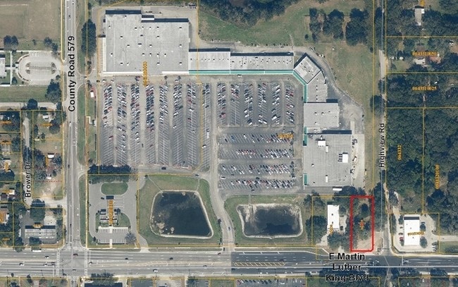
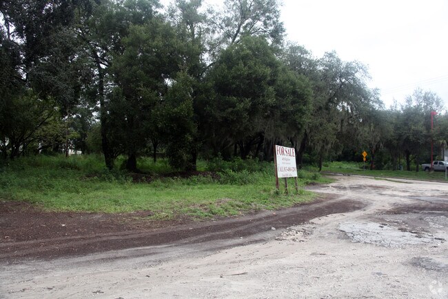
Property Record
4016 Highview Rd, Seffner, FL 33584

Property Detail
4016 Highview Rd
U-03-29-20-ZZZ-000002-34580.0
LOT BEG 33 FT N AND 25 FT W OF SE COR OF SW 1/4 OF SW 1/4 AND RUN N 262 FT W 114.5 FT S 262 FT AND E 114.5 FT TO BEG LESS RD R/W
Stripcommercialcenter
Hillsborough
PD
Florida
B and X Area of moderate flood hazard, usually the area between the limits of the 100-year and 500-year floods.
34580
2024
0.48 AC
2025
East Tampa
012107
Tampa/St Petersburg
4,980 SF
Tampa-St. Petersburg-Clearwater, FL
NEARBY LISTINGS FOR SALE OR LEASE
DEMOGRAPHICS near 4016 Highview Rd
1 mile
3 mile
5 mile
2025 Total Population
11,092
75,082
157,959
2030 Population
11,961
80,433
169,654
Pop Growth 2025-2030
+ 7.83%
+ 7.13%
+ 7.40%
Average Age
38
39
39
2025 Total Households
3,933
26,770
58,850
HH Growth 2025-2030
+ 8.01%
+ 7.45%
+ 7.69%
Median Household Inc
$59,507
$72,702
$72,839
Avg Household Size
2.80
2.70
2.60
2025 Avg HH Vehicles
2.00
2.00
2.00
Median Home Value
$304,357
$336,842
$345,841
Median Year Built
1985
1989
1992
Nearby Places
Map Layers
Map Styles
 Street
 Aerial
Transit
 Traffic
 Biking
Places
Listings with unknown addresses are not visible on the map
- Restaurants
- Banks
- Shops
- Fitness
- Groceries
PUBLIC TRANSPORTATION
AIRPORT
Tampa International
Drive
Walk
Distance
Tampa International
28 min
18.5 mi
St Pete-Clearwater International
Drive
Walk
Distance
St Pete-Clearwater International
39 min
27.0 mi
Freight Ports
Port of Tampa Bay
Drive
Walk
Distance
Port of Tampa Bay
21 min
11.9 mi
Nearby Properties
Address
Land Use
TOTAL SIZE
Lot Size
Zoning
Address
Land Use
TOTAL SIZE
Lot Size
Zoning
1,122,007 SF
181.48 AC
PD
Address
Land Use
TOTAL SIZE
Lot Size
Zoning
676,710 SF
64.79 AC
PD
Address
Land Use
TOTAL SIZE
Lot Size
Zoning
472,855 SF
34.23 AC
PD
Address
Land Use
TOTAL SIZE
Lot Size
Zoning
466,038 SF
26.75 AC
PD
Address
Land Use
TOTAL SIZE
Lot Size
Zoning
491,498 SF
35.60 AC
PD
Address
Land Use
TOTAL SIZE
Lot Size
Zoning
398,440 SF
48.63 AC
IPD-1
Address
Land Use
TOTAL SIZE
Lot Size
Zoning
333,142 SF
51.21 AC
AR
Address
Land Use
TOTAL SIZE
Lot Size
Zoning
425,350 SF
38.72 AC
PD
Address
Land Use
TOTAL SIZE
Lot Size
Zoning
283,777 SF
36.66 AC
PD
Address
Land Use
TOTAL SIZE
Lot Size
Zoning
635,413 SF
43.44 AC
PD
Address
Land Use
TOTAL SIZE
Lot Size
Zoning
174,144 SF
79.80 AC
PD
Address
Land Use
TOTAL SIZE
Lot Size
Zoning
159,876 SF
19.37 AC
PD
Address
Land Use
TOTAL SIZE
Lot Size
Zoning
185,966 SF
14.96 AC
PD
Address
Land Use
TOTAL SIZE
Lot Size
Zoning
253,720 SF
81.03 AC
M
Address
Land Use
TOTAL SIZE
Lot Size
Zoning
165,277 SF
27.50 AC
AR
Address
Land Use
TOTAL SIZE
Lot Size
Zoning
143,487 SF
8.85 AC
RMC-9
Address
Land Use
TOTAL SIZE
Lot Size
Zoning
236,297 SF
15.58 AC
PD
Address
Land Use
TOTAL SIZE
Lot Size
Zoning
120,471 SF
63.04 AC
M
Address
Land Use
TOTAL SIZE
Lot Size
Zoning
131,808 SF
8.77 AC
PD
Address
Land Use
TOTAL SIZE
Lot Size
Zoning
129,696 SF
8.93 AC
PD
Address
Land Use
TOTAL SIZE
Lot Size
Zoning
307,520 SF
23.22 AC
IPD-1
Address
Land Use
TOTAL SIZE
Lot Size
Zoning
325,781 SF
18.88 AC
PD
Address
Land Use
TOTAL SIZE
Lot Size
Zoning
302,054 SF
68.34 AC
RSC-6
Address
Land Use
TOTAL SIZE
Lot Size
Zoning
140,025 SF
5.94 AC
PD
Address
Land Use
TOTAL SIZE
Lot Size
Zoning
397,513 SF
22.91 AC
PD
Address
Land Use
TOTAL SIZE
Lot Size
Zoning
213,686 SF
12.33 AC
PD
Address
Land Use
TOTAL SIZE
Lot Size
Zoning
123,408 SF
11.84 AC
M
Address
Land Use
TOTAL SIZE
Lot Size
Zoning
94,653 SF
17.31 AC
PD
Address
Land Use
TOTAL SIZE
Lot Size
Zoning
101,256 SF
5.91 AC
PD
Address
Land Use
TOTAL SIZE
Lot Size
Zoning
29,978 SF
20.49 AC
PD
The World's #1 Commercial Real Estate Marketplace
Connect with us
© 2026 CoStar Group
The information above has been obtained from sources believed reliable. While we do not doubt its accuracy we have not verified it and make no guarantee, warranty or representation about it. It is your responsibility to independently confirm its accuracy and completeness. Any projections, opinions, assumptions, or estimates used are for example only and do not represent the current or future performance of the property. The value of this transaction to you depends on tax and other factors which should be evaluated by your tax, financial, and legal advisors. You and your advisors should conduct a careful, independent investigation of the property to determine to your satisfaction the suitability of the property for your needs.