Property Record
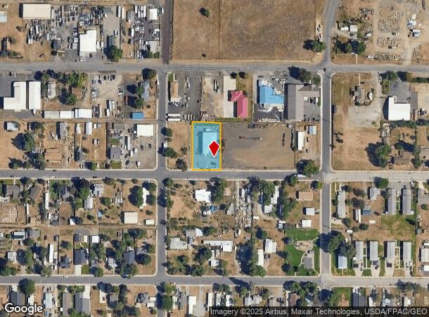
4017 E Princeton Ave, Spokane, WA 99217


NEARBY LISTINGS FOR SALE OR LEASE
Property Detail
4017 E Princeton Ave
Spokane-Spokane Valley, WA
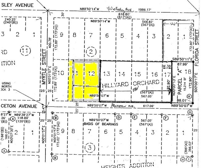
Hillyard Orchard Heights Addition
35031.0220
HILLYARD ORCHARD HEIGHTS ADDITION E 44 LOT 11 ALL OF LOT 12 BLOCK 2
Wholesaleoutletdiscountstore
Spokane
X
Washington
53063C0555D
11,12
2025
0.43 AC
2025
SE North Metro
014400
Spokane
4,150 SF
DEMOGRAPHICS near 4017 E Princeton Ave
1 mile
3 mile
5 mile
2024 Total Population
5,004
73,940
208,497
2029 Population
5,342
78,645
221,604
Pop Growth 2024-2029
+ 6.75%
+ 6.36%
+ 6.29%
Average Age
38
38
39
2024 Total Households
1,897
29,572
84,873
HH Growth 2024-2029
+ 6.85%
+ 6.54%
+ 6.55%
Median Household Inc
$44,609
$51,491
$56,015
Avg Household Size
2.50
2.40
2.30
2024 Avg HH Vehicles
2.00
2.00
2.00
Median Home Value
$215,047
$236,377
$285,715
Median Year Built
1967
1962
1963
Nearby Places
Map Layers
Map Styles
 Street
 Aerial
Transit
 Traffic
 Biking
Places
Listings with unknown addresses are not visible on the map
- Restaurants
- Banks
- Shops
- Fitness
- Groceries
PUBLIC TRANSPORTATION
COMMUTER RAIL
Spokane (Empire Builder - Amtrak)
Drive
Walk
Distance
Spokane (Empire Builder - Amtrak)
15 min
5.5 mi
AIRPORT
Spokane International
Drive
Walk
Distance
Spokane International
23 min
12.8 mi
Freight Ports
Port of Everett
Drive
Walk
Distance
Port of Everett
351 min
308.4 mi
Nearby Properties
Address
Land Use
TOTAL SIZE
Lot Size
Zoning
Address
Land Use
TOTAL SIZE
Lot Size
Zoning
917,113 SF
100.67 AC
LI
Address
Land Use
TOTAL SIZE
Lot Size
Zoning
531,295 SF
17.11 AC
CC2
Address
Land Use
TOTAL SIZE
Lot Size
Zoning
427,054 SF
16.60 AC
LI
Address
Land Use
TOTAL SIZE
Lot Size
Zoning
386,885 SF
22.81 AC
RSF
Address
Land Use
TOTAL SIZE
Lot Size
Zoning
310,606 SF
27.56 AC
RMF
Address
Land Use
TOTAL SIZE
Lot Size
Zoning
180,822 SF
16.11 AC
CC1
Address
Land Use
TOTAL SIZE
Lot Size
Zoning
696,382 SF
37.43 AC
LI
Address
Land Use
TOTAL SIZE
Lot Size
Zoning
379,678 SF
20.64 AC
LI
Address
Land Use
TOTAL SIZE
Lot Size
Zoning
1,555,116 SF
23.12 AC
GC
Address
Land Use
TOTAL SIZE
Lot Size
Zoning
378,750 SF
17.38 AC
R-2
Address
Land Use
TOTAL SIZE
Lot Size
Zoning
108,237 SF
3.48 AC
LI
Address
Land Use
TOTAL SIZE
Lot Size
Zoning
58,522 SF
19.91 AC
HI
Address
Land Use
TOTAL SIZE
Lot Size
Zoning
134,806 SF
7.79 AC
RMF
Address
Land Use
TOTAL SIZE
Lot Size
Zoning
136,780 SF
8.75 AC
RMF
Address
Land Use
TOTAL SIZE
Lot Size
Zoning
101,372 SF
5.48 AC
RMF
Address
Land Use
TOTAL SIZE
Lot Size
Zoning
153,780 SF
10.31 AC
RMF
Address
Land Use
TOTAL SIZE
Lot Size
Zoning
95,030 SF
3.51 AC
CC1
Address
Land Use
TOTAL SIZE
Lot Size
Zoning
160,810 SF
25.18 AC
RMF
Address
Land Use
TOTAL SIZE
Lot Size
Zoning
96,424 SF
9.04 AC
I-1
Address
Land Use
TOTAL SIZE
Lot Size
Zoning
59,441 SF
2.04 AC
GC
Address
Land Use
TOTAL SIZE
Lot Size
Zoning
125,588 SF
12.84 AC
RMF
Address
Land Use
TOTAL SIZE
Lot Size
Zoning
142,448 SF
14.85 AC
RMF
Address
Land Use
TOTAL SIZE
Lot Size
Zoning
134,104 SF
5.89 AC
HDR
Address
Land Use
TOTAL SIZE
Lot Size
Zoning
150,812 SF
17.49 AC
RC
Address
Land Use
TOTAL SIZE
Lot Size
Zoning
107,539 SF
7.54 AC
RMF
Address
Land Use
TOTAL SIZE
Lot Size
Zoning
123,142 SF
2.22 AC
RHD
Address
Land Use
TOTAL SIZE
Lot Size
Zoning
103,755 SF
7.64 AC
CC2
Address
Land Use
TOTAL SIZE
Lot Size
Zoning
68,197 SF
5.16 AC
RSF
Address
Land Use
TOTAL SIZE
Lot Size
Zoning
118,818 SF
7.96 AC
HDR
Address
Land Use
TOTAL SIZE
Lot Size
Zoning
138,078 SF
8.44 AC
HI
The World's #1 Commercial Real Estate Marketplace
Connect with us
© 2026 CoStar Group
The information above has been obtained from sources believed reliable. While we do not doubt its accuracy we have not verified it and make no guarantee, warranty or representation about it. It is your responsibility to independently confirm its accuracy and completeness. Any projections, opinions, assumptions, or estimates used are for example only and do not represent the current or future performance of the property. The value of this transaction to you depends on tax and other factors which should be evaluated by your tax, financial, and legal advisors. You and your advisors should conduct a careful, independent investigation of the property to determine to your satisfaction the suitability of the property for your needs.