Property Record
4017 Highway 320, Carnesville, GA 30521
NEARBY LISTINGS FOR SALE OR LEASE
-
-
View all Carnesville listings for sale on LoopNet.com
Property Detail
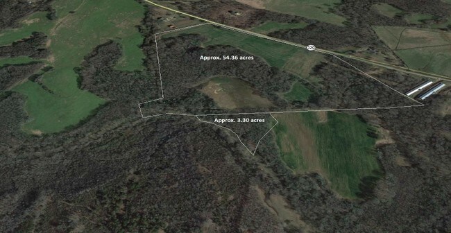
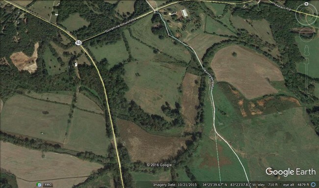
4017 Highway 320
019-017
Poultry Farm Hwy
Privatepreserveopenspacevacantlandforestlandconservation
3.30 AC GA HWY 320
X
Franklin
13119C0100C
Georgia
2025
54.36 AC
2025
Georgia Northeast
890201
Other Market Areas
DEMOGRAPHICS near 4017 Highway 320
1 Mile
3 Mile
5 Mile
2024 Total Population
48
1,334
4,928
2029 Population
51
1,418
5,264
Pop Growth 2024-2029
+ 6.25%
+ 6.30%
+ 6.82%
Average Age
42
42
42
2024 Total Households
18
504
1,851
HH Growth 2024-2029
+ 5.56%
+ 5.95%
+ 6.59%
Median Household Inc
$47,500
$50,446
$51,364
Avg Household Size
2.60
2.60
2.60
2024 Avg HH Vehicles
3.00
2.00
2.00
Median Home Value
$183,333
$191,509
$173,411
Median Year Built
1992
1990
1990
Nearby Places
Map Layers
Map Styles
 Street
 Aerial
- Restaurants
- Banks
- Shops
- Fitness
- Groceries
SALE & LEASE HISTORY
LISTING DATE
SALE/LEASE

Sep 24, 2016
For Sale
Nov 07, 2016
For Sale
Feb 13, 2019
For Sale
Nearby Properties
Address
Land Use
TOTAL SIZE
Lot Size
Zoning
Address
Land Use
TOTAL SIZE
Lot Size
Zoning
1,500 SF
31.67 AC
UNZONED RU
Address
Land Use
TOTAL SIZE
Lot Size
Zoning
310.35 AC
UNZONED RU
Address
Land Use
TOTAL SIZE
Lot Size
Zoning
209.08 AC
UNZONED RU
Address
Land Use
TOTAL SIZE
Lot Size
Zoning
194.60 AC
UNZONED RU
Address
Land Use
TOTAL SIZE
Lot Size
Zoning
156.90 AC
UNZONED RU
Address
Land Use
TOTAL SIZE
Lot Size
Zoning
4,000 SF
5.94 AC
Address
Land Use
TOTAL SIZE
Lot Size
Zoning
3,248 SF
160.77 AC
UNZONED RU
Address
Land Use
TOTAL SIZE
Lot Size
Zoning
106.29 AC
UNZONED RU
Address
Land Use
TOTAL SIZE
Lot Size
Zoning
34.87 AC
UNZONED RU
Address
Land Use
TOTAL SIZE
Lot Size
Zoning
41.70 AC
UNZONED RU
Address
Land Use
TOTAL SIZE
Lot Size
Zoning
139.22 AC
UNZONED RU
Address
Land Use
TOTAL SIZE
Lot Size
Zoning
14,530 SF
4 AC
UNZONED RU
Address
Land Use
TOTAL SIZE
Lot Size
Zoning
131.78 AC
UNZONED RU
Address
Land Use
TOTAL SIZE
Lot Size
Zoning
1,400 SF
5.02 AC
COMMERCIAL
Address
Land Use
TOTAL SIZE
Lot Size
Zoning
1,959 SF
128.07 AC
UNZONED RU
Address
Land Use
TOTAL SIZE
Lot Size
Zoning
105.87 AC
UNZONED RU
Address
Land Use
TOTAL SIZE
Lot Size
Zoning
8,200 SF
7.02 AC
UNZONED RU
Address
Land Use
TOTAL SIZE
Lot Size
Zoning
1,664 SF
53.03 AC
RESIDENTIA
Address
Land Use
TOTAL SIZE
Lot Size
Zoning
94.38 AC
UNZONED RU
Address
Land Use
TOTAL SIZE
Lot Size
Zoning
195.93 AC
UNZONED RU
Address
Land Use
TOTAL SIZE
Lot Size
Zoning
9,000 SF
36.18 AC
COMMERCIAL
Address
Land Use
TOTAL SIZE
Lot Size
Zoning
93.82 AC
UNZONED RU
Address
Land Use
TOTAL SIZE
Lot Size
Zoning
90 AC
UNZONED RU
Address
Land Use
TOTAL SIZE
Lot Size
Zoning
87.42 AC
UNZONED RU
Address
Land Use
TOTAL SIZE
Lot Size
Zoning
2,992 SF
4.30 AC
UNZONED RU
Address
Land Use
TOTAL SIZE
Lot Size
Zoning
69.56 AC
UNZONED RU
Address
Land Use
TOTAL SIZE
Lot Size
Zoning
960 SF
10.28 AC
UNZONED RU
Address
Land Use
TOTAL SIZE
Lot Size
Zoning
83.08 AC
UNZONED RU
Address
Land Use
TOTAL SIZE
Lot Size
Zoning
80.11 AC
UNZONED RU
Address
Land Use
TOTAL SIZE
Lot Size
Zoning
665 SF
39.48 AC
UNZONED RU
The World's #1 Commercial Real Estate Marketplace
Connect with us
© 2025 CoStar Group
The information above has been obtained from sources believed reliable. While we do not doubt its accuracy we have not verified it and make no guarantee, warranty or representation about it. It is your responsibility to independently confirm its accuracy and completeness. Any projections, opinions, assumptions, or estimates used are for example only and do not represent the current or future performance of the property. The value of this transaction to you depends on tax and other factors which should be evaluated by your tax, financial, and legal advisors. You and your advisors should conduct a careful, independent investigation of the property to determine to your satisfaction the suitability of the property for your needs.