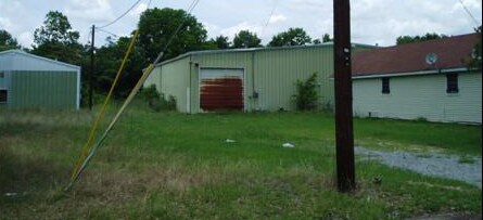
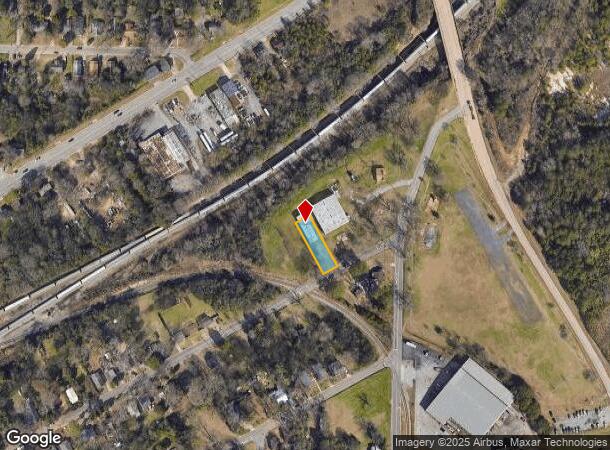
Property Record
4017 Worsham Ave, Macon, GA 31206
NEARBY LISTINGS FOR SALE OR LEASE
Property Detail
4017 Worsham Ave
Macon-Bibb County, GA
Lynmore Estates
Q101-0130
LYNMORE ESTS
Warehouse
Bibb
X
Georgia
13021C0142G
7
2025
0.23 AC
2025
Macon
012600
Atlanta
2,880 SF
DEMOGRAPHICS near 4017 Worsham Ave
1 mile
3 mile
5 mile
2024 Total Population
5,257
25,661
74,944
2029 Population
5,363
25,757
75,276
Pop Growth 2024-2029
+ 2.02%
+ 0.37%
+ 0.44%
Average Age
36
36
37
2024 Total Households
1,947
9,317
29,702
HH Growth 2024-2029
+ 2.05%
+ 0.94%
+ 0.53%
Median Household Inc
$23,901
$27,956
$33,079
Avg Household Size
2.50
2.40
2.30
2024 Avg HH Vehicles
1.00
1.00
1.00
Median Home Value
$72,774
$74,215
$94,057
Median Year Built
1959
1961
1965
Nearby Places
Map Layers
Map Styles
 Street
 Aerial
Transit
 Traffic
 Biking
Places
Listings with unknown addresses are not visible on the map
- Restaurants
- Banks
- Shops
- Fitness
- Groceries
Nearby Properties
Address
Land Use
TOTAL SIZE
Lot Size
Zoning
Address
Land Use
TOTAL SIZE
Lot Size
Zoning
6,681 SF
123.97 AC
R-3
Address
Land Use
TOTAL SIZE
Lot Size
Zoning
55,368 SF
9.53 AC
CBD-2
Address
Land Use
TOTAL SIZE
Lot Size
Zoning
63,394 SF
5.30 AC
M-1/R-3
Address
Land Use
TOTAL SIZE
Lot Size
Zoning
100,599 SF
0.43 AC
CBD-1
Address
Land Use
TOTAL SIZE
Lot Size
Zoning
158,480 SF
0.90 AC
CBD-2
Address
Land Use
TOTAL SIZE
Lot Size
Zoning
181,396 SF
44.77 AC
R-1A
Address
Land Use
TOTAL SIZE
Lot Size
Zoning
12,817 SF
357.49 AC
M-2
Address
Land Use
TOTAL SIZE
Lot Size
Zoning
1,428 SF
64.46 AC
R-1A
Address
Land Use
TOTAL SIZE
Lot Size
Zoning
18,128 SF
95 AC
M-2
Address
Land Use
TOTAL SIZE
Lot Size
Zoning
92,712 SF
2.93 AC
CBD-2
Address
Land Use
TOTAL SIZE
Lot Size
Zoning
98,928 SF
12.32 AC
R-3
Address
Land Use
TOTAL SIZE
Lot Size
Zoning
110,153 SF
22 AC
R-2
Address
Land Use
TOTAL SIZE
Lot Size
Zoning
46,288 SF
1.80 AC
PDE
Address
Land Use
TOTAL SIZE
Lot Size
Zoning
33,248 SF
10.18 AC
R-3
Address
Land Use
TOTAL SIZE
Lot Size
Zoning
119,564 SF
3.89 AC
R-3
Address
Land Use
TOTAL SIZE
Lot Size
Zoning
58,730 SF
3.42 AC
R-3
Address
Land Use
TOTAL SIZE
Lot Size
Zoning
46,174 SF
9.67 AC
R-2
Address
Land Use
TOTAL SIZE
Lot Size
Zoning
72,073 SF
0.96 AC
CBD-1
Address
Land Use
TOTAL SIZE
Lot Size
Zoning
133,862 SF
25.44 AC
C-2
Address
Land Use
TOTAL SIZE
Lot Size
Zoning
72,048 SF
2.84 AC
R-2
Address
Land Use
TOTAL SIZE
Lot Size
Zoning
8,480 SF
7.92 AC
HPD-BH
Address
Land Use
TOTAL SIZE
Lot Size
Zoning
108,418 SF
24.45 AC
R-1A
Address
Land Use
TOTAL SIZE
Lot Size
Zoning
30,096 SF
6.63 AC
PDR
Address
Land Use
TOTAL SIZE
Lot Size
Zoning
77,346 SF
1.56 AC
PDE
Address
Land Use
TOTAL SIZE
Lot Size
Zoning
44,323 SF
2.76 AC
PDE
Address
Land Use
TOTAL SIZE
Lot Size
Zoning
367,112 SF
1.83 AC
CBD-2
Address
Land Use
TOTAL SIZE
Lot Size
Zoning
32,300 SF
24.40 AC
R-2
Address
Land Use
TOTAL SIZE
Lot Size
Zoning
174,764 SF
Address
Land Use
TOTAL SIZE
Lot Size
Zoning
100,192 SF
30.29 AC
C-2
Address
Land Use
TOTAL SIZE
Lot Size
Zoning
5,400 SF
2.97 AC
HPD-BH
The World's #1 Commercial Real Estate Marketplace
Connect with us
© 2026 CoStar Group
The information above has been obtained from sources believed reliable. While we do not doubt its accuracy we have not verified it and make no guarantee, warranty or representation about it. It is your responsibility to independently confirm its accuracy and completeness. Any projections, opinions, assumptions, or estimates used are for example only and do not represent the current or future performance of the property. The value of this transaction to you depends on tax and other factors which should be evaluated by your tax, financial, and legal advisors. You and your advisors should conduct a careful, independent investigation of the property to determine to your satisfaction the suitability of the property for your needs.