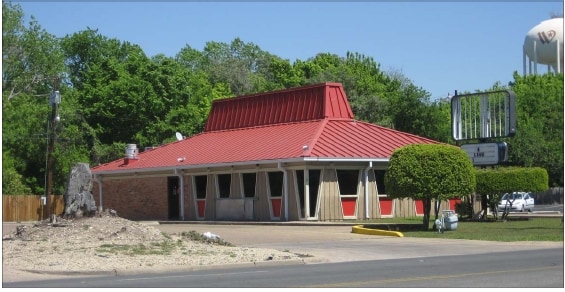
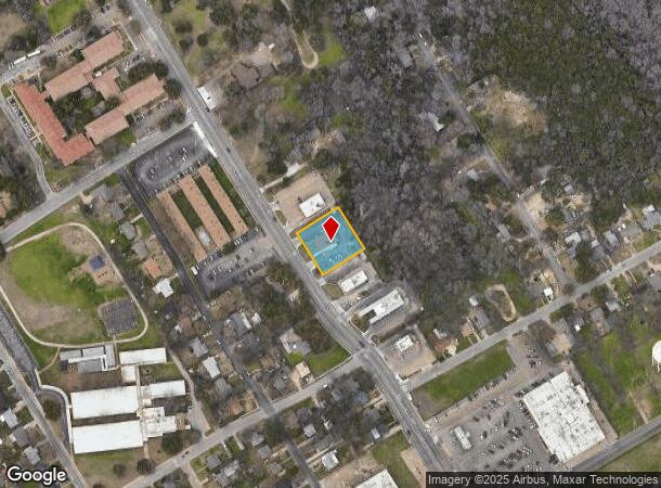
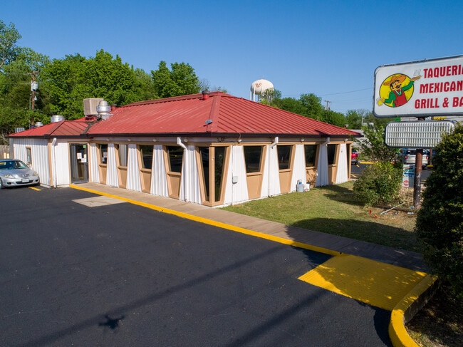
Property Record
4019 N 19Th St, Waco, TX 76708
Property Detail
4019 N 19Th St
Waco, TX
Cedars The
48-008300-002100-5
CEDARS THE LOT 2 BLOCK 4 ACRES .5165
Commercialnec
Mclennan
X
Texas
48309C0360D
2
2024
0.52 AC
2025
Waco
003000
Other Market Areas
2,415 SF
NEARBY LISTINGS FOR SALE OR LEASE
DEMOGRAPHICS near 4019 N 19Th St
1 mile
3 mile
5 mile
2024 Total Population
7,791
49,072
121,506
2029 Population
8,270
52,172
129,385
Pop Growth 2024-2029
+ 6.15%
+ 6.32%
+ 6.48%
Average Age
39
36
35
2024 Total Households
3,188
18,626
45,532
HH Growth 2024-2029
+ 6.18%
+ 6.44%
+ 6.85%
Median Household Inc
$44,552
$42,139
$42,446
Avg Household Size
2.30
2.50
2.40
2024 Avg HH Vehicles
2.00
2.00
2.00
Median Home Value
$123,374
$149,288
$147,267
Median Year Built
1968
1965
1971
Nearby Places
Map Layers
Map Styles
 Street
 Aerial
Transit
 Traffic
 Biking
Places
Listings with unknown addresses are not visible on the map
- Restaurants
- Banks
- Shops
- Fitness
- Groceries
PUBLIC TRANSPORTATION
AIRPORT
Waco Regional
Drive
Walk
Distance
Waco Regional
13 min
4.9 mi
SALE & LEASE HISTORY
LISTING DATE
SALE/LEASE

Nov 10, 2021
For Sale
Apr 25, 2022
For Sale
Nearby Properties
Address
Land Use
TOTAL SIZE
Lot Size
Zoning
Address
Land Use
TOTAL SIZE
Lot Size
Zoning
452,498 SF
39.43 AC
C-2
Address
Land Use
TOTAL SIZE
Lot Size
Zoning
193,780 SF
14.12 AC
C
Address
Land Use
TOTAL SIZE
Lot Size
Zoning
214,351 SF
19.37 AC
R3B
Address
Land Use
TOTAL SIZE
Lot Size
Zoning
19,209 SF
149.75 AC
O2
Address
Land Use
TOTAL SIZE
Lot Size
Zoning
189,996 SF
13.98 AC
O2
Address
Land Use
TOTAL SIZE
Lot Size
Zoning
167,206 SF
11.22 AC
R-3C
Address
Land Use
TOTAL SIZE
Lot Size
Zoning
238,580 SF
12.25 AC
R-3E
Address
Land Use
TOTAL SIZE
Lot Size
Zoning
74,664 SF
3.55 AC
2007 TIF
Address
Land Use
TOTAL SIZE
Lot Size
Zoning
205,184 SF
18.71 AC
R3D
Address
Land Use
TOTAL SIZE
Lot Size
Zoning
32,870 SF
100 AC
TIF3
Address
Land Use
TOTAL SIZE
Lot Size
Zoning
164,572 SF
125.14 AC
Address
Land Use
TOTAL SIZE
Lot Size
Zoning
111,840 SF
38.94 AC
R1B
Address
Land Use
TOTAL SIZE
Lot Size
Zoning
158,050 SF
17.19 AC
R-2
Address
Land Use
TOTAL SIZE
Lot Size
Zoning
137,233 SF
3.51 AC
O2
Address
Land Use
TOTAL SIZE
Lot Size
Zoning
50,570 SF
6.25 AC
2007 TIF
Address
Land Use
TOTAL SIZE
Lot Size
Zoning
102,910 SF
6.38 AC
TIF2
Address
Land Use
TOTAL SIZE
Lot Size
Zoning
93,623 SF
4.26 AC
C2
Address
Land Use
TOTAL SIZE
Lot Size
Zoning
239,020 SF
38.81 AC
R1B
Address
Land Use
TOTAL SIZE
Lot Size
Zoning
4,790 SF
20.68 AC
R
Address
Land Use
TOTAL SIZE
Lot Size
Zoning
61,752 SF
3.68 AC
C2
Address
Land Use
TOTAL SIZE
Lot Size
Zoning
52,932 SF
2.83 AC
2007 TIF
Address
Land Use
TOTAL SIZE
Lot Size
Zoning
79,440 SF
0.97 AC
2007 TIF
Address
Land Use
TOTAL SIZE
Lot Size
Zoning
58,414 SF
0.46 AC
2007 TIF
Address
Land Use
TOTAL SIZE
Lot Size
Zoning
127,586 SF
12.78 AC
R-3B
Address
Land Use
TOTAL SIZE
Lot Size
Zoning
3.12 AC
R3D
Address
Land Use
TOTAL SIZE
Lot Size
Zoning
4.26 AC
2007 TIF
Address
Land Use
TOTAL SIZE
Lot Size
Zoning
11,487 SF
85.25 AC
R
Address
Land Use
TOTAL SIZE
Lot Size
Zoning
69,642 SF
27.76 AC
R1B
Address
Land Use
TOTAL SIZE
Lot Size
Zoning
50,245 SF
2.15 AC
C2
Address
Land Use
TOTAL SIZE
Lot Size
Zoning
95,336 SF
4.06 AC
R3E
The World's #1 Commercial Real Estate Marketplace
Connect with us
© 2026 CoStar Group
The information above has been obtained from sources believed reliable. While we do not doubt its accuracy we have not verified it and make no guarantee, warranty or representation about it. It is your responsibility to independently confirm its accuracy and completeness. Any projections, opinions, assumptions, or estimates used are for example only and do not represent the current or future performance of the property. The value of this transaction to you depends on tax and other factors which should be evaluated by your tax, financial, and legal advisors. You and your advisors should conduct a careful, independent investigation of the property to determine to your satisfaction the suitability of the property for your needs.