Property Record
4019 Reynolda Rd, Winston Salem, NC 27106
NEARBY LISTINGS FOR SALE OR LEASE
Property Detail
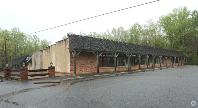
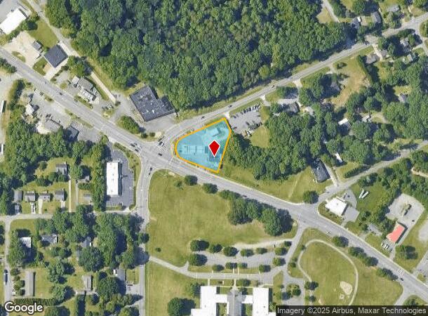
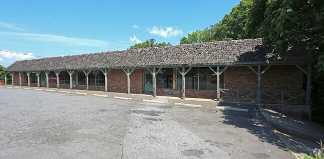
4019 Reynolda Rd
Winston-Salem, NC
Wilco Fuel Plaza
6808-62-4079
WILCO FUEL PLAZA LO:100 BL:3490 BU:1
Storebuilding
Forsyth
X
North Carolina
3710680800J
100
2024
0.85 AC
2025
NW Forsyth County
002701
Greensboro/Winston-Salem
105 SF
DEMOGRAPHICS near 4019 Reynolda Rd
1 Mile
3 Mile
5 Mile
2024 Total Population
5,716
36,158
88,080
2029 Population
5,941
37,545
91,652
Pop Growth 2024-2029
+ 3.94%
+ 3.84%
+ 4.06%
Average Age
38
40
39
2024 Total Households
2,147
15,017
34,813
HH Growth 2024-2029
+ 3.96%
+ 3.79%
+ 4.17%
Median Household Inc
$66,503
$64,339
$68,850
Avg Household Size
2.60
2.30
2.30
2024 Avg HH Vehicles
2.00
2.00
2.00
Median Home Value
$194,949
$224,522
$248,782
Median Year Built
1988
1984
1982
Nearby Places
Map Layers
Map Styles
 Street
 Aerial
- Restaurants
- Banks
- Shops
- Fitness
- Groceries
PUBLIC TRANSPORTATION
AIRPORT
Piedmont Triad International
DRIVE
WALK
Distance
Piedmont Triad International
47 min
28.6 mi
SALE & LEASE HISTORY
LISTING DATE
SALE/LEASE

Jul 07, 2017
For Sale
Nearby Properties
Address
Land Use
TOTAL SIZE
Lot Size
Zoning
Address
Land Use
TOTAL SIZE
Lot Size
Zoning
329,963 SF
58.84 AC
RM18-S
Address
Land Use
TOTAL SIZE
Lot Size
Zoning
153,937 SF
34.63 AC
RM12-S
Address
Land Use
TOTAL SIZE
Lot Size
Zoning
160,210 SF
33.21 AC
AG
Address
Land Use
TOTAL SIZE
Lot Size
Zoning
188,135 SF
8.65 AC
GO-S
Address
Land Use
TOTAL SIZE
Lot Size
Zoning
152,968 SF
32.40 AC
RM18
Address
Land Use
TOTAL SIZE
Lot Size
Zoning
91,905 SF
21.18 AC
RM18-S
Address
Land Use
TOTAL SIZE
Lot Size
Zoning
106,821 SF
14.95 AC
RM12-S
Address
Land Use
TOTAL SIZE
Lot Size
Zoning
741,857 SF
53.71 AC
GB-L
Address
Land Use
TOTAL SIZE
Lot Size
Zoning
12,132 SF
57.50 AC
RM18
Address
Land Use
TOTAL SIZE
Lot Size
Zoning
711,274 SF
38.24 AC
LI
Address
Land Use
TOTAL SIZE
Lot Size
Zoning
120,256 SF
43.62 AC
GB-S,IP
Address
Land Use
TOTAL SIZE
Lot Size
Zoning
82,843 SF
16.06 AC
RM18
Address
Land Use
TOTAL SIZE
Lot Size
Zoning
141,377 SF
37.07 AC
IP
Address
Land Use
TOTAL SIZE
Lot Size
Zoning
99,460 SF
17.17 AC
RM18
Address
Land Use
TOTAL SIZE
Lot Size
Zoning
67,643 SF
19.19 AC
RM12-S
Address
Land Use
TOTAL SIZE
Lot Size
Zoning
89,957 SF
14.65 AC
RM18
Address
Land Use
TOTAL SIZE
Lot Size
Zoning
93,541 SF
10.75 AC
RM18
Address
Land Use
TOTAL SIZE
Lot Size
Zoning
57,152 SF
9.82 AC
RM18-S
Address
Land Use
TOTAL SIZE
Lot Size
Zoning
95,375 SF
20.15 AC
RS9
Address
Land Use
TOTAL SIZE
Lot Size
Zoning
51,100 SF
11.29 AC
RM18-S
Address
Land Use
TOTAL SIZE
Lot Size
Zoning
56,653 SF
13.83 AC
RM12-S,RM1
Address
Land Use
TOTAL SIZE
Lot Size
Zoning
169,173 SF
12 AC
GB
Address
Land Use
TOTAL SIZE
Lot Size
Zoning
73,058 SF
3.95 AC
GO-S
Address
Land Use
TOTAL SIZE
Lot Size
Zoning
68,730 SF
8.97 AC
RM18
Address
Land Use
TOTAL SIZE
Lot Size
Zoning
79,327 SF
22.97 AC
RS9
Address
Land Use
TOTAL SIZE
Lot Size
Zoning
71,548 SF
11.15 AC
RM18
Address
Land Use
TOTAL SIZE
Lot Size
Zoning
45,326 SF
7.49 AC
RM18
Address
Land Use
TOTAL SIZE
Lot Size
Zoning
150,753 SF
11.49 AC
HB
Address
Land Use
TOTAL SIZE
Lot Size
Zoning
333.30 AC
GI-S
Address
Land Use
TOTAL SIZE
Lot Size
Zoning
81,703 SF
8.34 AC
HB
The World's #1 Commercial Real Estate Marketplace
Connect with us
© 2025 CoStar Group
The information above has been obtained from sources believed reliable. While we do not doubt its accuracy we have not verified it and make no guarantee, warranty or representation about it. It is your responsibility to independently confirm its accuracy and completeness. Any projections, opinions, assumptions, or estimates used are for example only and do not represent the current or future performance of the property. The value of this transaction to you depends on tax and other factors which should be evaluated by your tax, financial, and legal advisors. You and your advisors should conduct a careful, independent investigation of the property to determine to your satisfaction the suitability of the property for your needs.