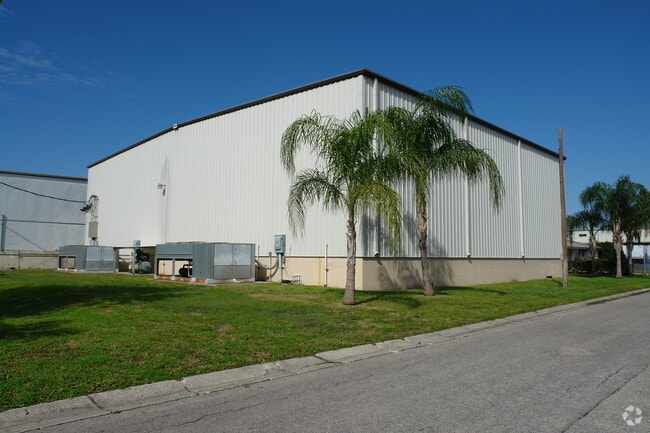
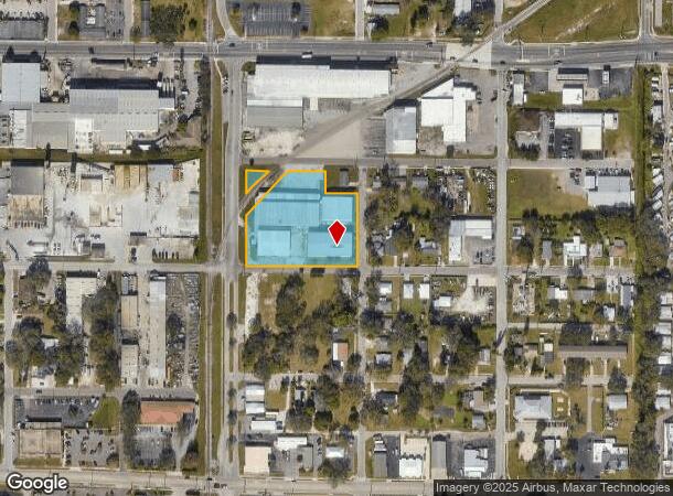
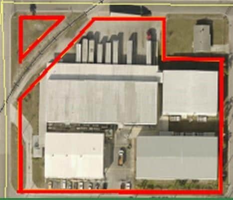
Property Record
402 9Th St W, Palmetto, FL 34221
NEARBY LISTINGS FOR SALE OR LEASE
Property Detail
402 9Th St W
North Port-Sarasota-Bradenton, FL
East Palmetto Plat
27889-0005-9
PARCEL 6: LOTS 1 THRU 14, INCLUSIVE, OF BLK D PLAT OF EAST PALMETTO; ALSO THE VACATED 20 FT WIDE ALLEY (OR BK 1488 PG 3565) WITHIN SD BLK D; LESS S.C.L. R/R, 50 FT WIDE
Packing
Manatee
X
Florida
12081C0164F
1
2024
2.08 AC
2025
Manatee
001300
Tampa/St Petersburg
50,374 SF
DEMOGRAPHICS near 402 9Th St W
1 Mile
3 Mile
5 Mile
2024 Total Population
11,980
63,452
169,116
2029 Population
14,330
74,559
197,637
Pop Growth 2024-2029
+ 19.62%
+ 17.50%
+ 16.86%
Average Age
43
42
45
2024 Total Households
4,600
24,784
69,531
HH Growth 2024-2029
+ 19.17%
+ 16.97%
+ 16.14%
Median Household Inc
$46,496
$51,373
$53,614
Avg Household Size
2.50
2.40
2.30
2024 Avg HH Vehicles
2.00
2.00
2.00
Median Home Value
$167,579
$232,325
$228,287
Median Year Built
1985
1978
1981
Nearby Places
Map Layers
Map Styles
 Street
 Aerial
- Restaurants
- Banks
- Shops
- Fitness
- Groceries
PUBLIC TRANSPORTATION
AIRPORT
Sarasota/Bradenton International
DRIVE
WALK
Distance
Sarasota/Bradenton International
19 min
10.0 mi
St Pete-Clearwater International
DRIVE
WALK
Distance
St Pete-Clearwater International
50 min
34.2 mi
Freight Ports
Port Manatee
DRIVE
WALK
Distance
Port Manatee
17 min
9.9 mi
SALE & LEASE HISTORY
LISTING DATE
SALE/LEASE

Sep 27, 2021
For Lease
Nearby Properties
Address
Land Use
TOTAL SIZE
Lot Size
Zoning
Address
Land Use
TOTAL SIZE
Lot Size
Zoning
595,475 SF
16.90 AC
BR_T5
Address
Land Use
TOTAL SIZE
Lot Size
Zoning
349,711 SF
49.51 AC
BR_SD1
Address
Land Use
TOTAL SIZE
Lot Size
Zoning
405,843 SF
9.09 AC
BR_T5
Address
Land Use
TOTAL SIZE
Lot Size
Zoning
277,678 SF
7.80 AC
BR_T4-O, B
Address
Land Use
TOTAL SIZE
Lot Size
Zoning
427,250 SF
38.18 AC
A-1 SUBURB
Address
Land Use
TOTAL SIZE
Lot Size
Zoning
98,722 SF
10.24 AC
PL_P
Address
Land Use
TOTAL SIZE
Lot Size
Zoning
432,078 SF
1.64 AC
BR_T6
Address
Land Use
TOTAL SIZE
Lot Size
Zoning
169,485 SF
7.87 AC
PD-MU
Address
Land Use
TOTAL SIZE
Lot Size
Zoning
318,507 SF
10.47 AC
BR_T4R,BR_
Address
Land Use
TOTAL SIZE
Lot Size
Zoning
2,401,721 SF
142.14 AC
PD-UI
Address
Land Use
TOTAL SIZE
Lot Size
Zoning
257,072 SF
10.07 AC
BR_T5
Address
Land Use
TOTAL SIZE
Lot Size
Zoning
541,781 SF
3.48 AC
BR_T5
Address
Land Use
TOTAL SIZE
Lot Size
Zoning
885,776 SF
46.22 AC
LM LIGHT M
Address
Land Use
TOTAL SIZE
Lot Size
Zoning
318,680 SF
1.31 AC
BR_FBC,BR_
Address
Land Use
TOTAL SIZE
Lot Size
Zoning
499,823 SF
39.50 AC
PL_P
Address
Land Use
TOTAL SIZE
Lot Size
Zoning
185,617 SF
13.68 AC
BR_R-2
Address
Land Use
TOTAL SIZE
Lot Size
Zoning
166,810 SF
3.16 AC
BR_T4-O
Address
Land Use
TOTAL SIZE
Lot Size
Zoning
276,469 SF
10.90 AC
PD-MU
Address
Land Use
TOTAL SIZE
Lot Size
Zoning
163,582 SF
8.61 AC
PL_P
Address
Land Use
TOTAL SIZE
Lot Size
Zoning
196,346 SF
33.03 AC
BR_R-1
Address
Land Use
TOTAL SIZE
Lot Size
Zoning
360,846 SF
1.13 AC
BR_T5
Address
Land Use
TOTAL SIZE
Lot Size
Zoning
285,307 SF
5.17 AC
BR_T4-O
Address
Land Use
TOTAL SIZE
Lot Size
Zoning
229,863 SF
31.01 AC
PL_CG,PL_C
Address
Land Use
TOTAL SIZE
Lot Size
Zoning
86,462 SF
0.85 AC
BR_T6
Address
Land Use
TOTAL SIZE
Lot Size
Zoning
97,813 SF
2.51 AC
BR_T6
Address
Land Use
TOTAL SIZE
Lot Size
Zoning
257,697 SF
5.32 AC
PL_PD-H
Address
Land Use
TOTAL SIZE
Lot Size
Zoning
96,342 SF
0.58 AC
BR_T5
Address
Land Use
TOTAL SIZE
Lot Size
Zoning
228,067 SF
4.39 AC
BR_T4-O
Address
Land Use
TOTAL SIZE
Lot Size
Zoning
256,584 SF
12.57 AC
PD-MU
Address
Land Use
TOTAL SIZE
Lot Size
Zoning
193,582 SF
20.58 AC
PD-C,NC-S
The World's #1 Commercial Real Estate Marketplace
Connect with us
© 2025 CoStar Group
The information above has been obtained from sources believed reliable. While we do not doubt its accuracy we have not verified it and make no guarantee, warranty or representation about it. It is your responsibility to independently confirm its accuracy and completeness. Any projections, opinions, assumptions, or estimates used are for example only and do not represent the current or future performance of the property. The value of this transaction to you depends on tax and other factors which should be evaluated by your tax, financial, and legal advisors. You and your advisors should conduct a careful, independent investigation of the property to determine to your satisfaction the suitability of the property for your needs.