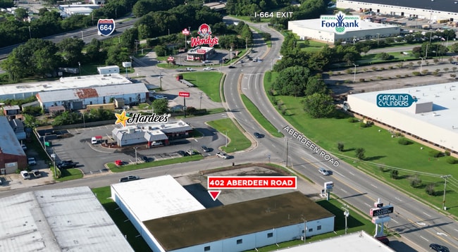
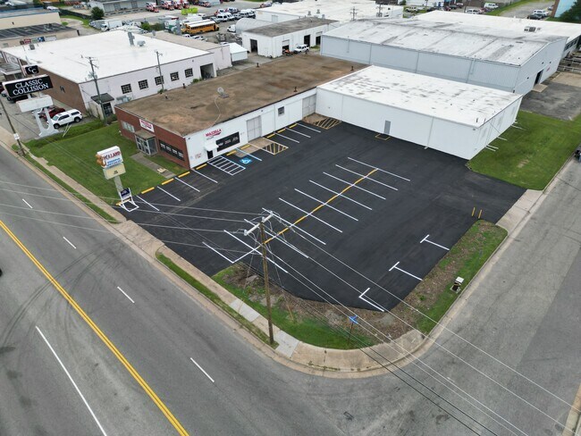
Property Record
402 Aberdeen Rd, Hampton, VA 23661

Property Detail
402 Aberdeen Rd
1000332
HAMPTON IND PARK 3 L9.10. BB
Warehouse
Hampton City
17 M-3 HEA
Virginia
B and X Area of moderate flood hazard, usually the area between the limits of the 100-year and 500-year floods.
9-10
2025
0.92 AC
2025
Copeland
010503
Hampton Roads
15,370 SF
Virginia Beach-Chesapeake-Norfolk, VA-NC
NEARBY LISTINGS FOR SALE OR LEASE
DEMOGRAPHICS near 402 Aberdeen Rd
1 mile
3 mile
5 mile
2024 Total Population
6,327
84,555
145,583
2029 Population
6,323
84,549
145,073
Pop Growth 2024-2029
(0.06%)
(0.01%)
(0.35%)
Average Age
40
39
39
2024 Total Households
2,706
36,220
61,646
HH Growth 2024-2029
(0.18%)
(0.09%)
(0.39%)
Median Household Inc
$55,637
$54,190
$61,873
Avg Household Size
2.30
2.20
2.20
2024 Avg HH Vehicles
2.00
2.00
2.00
Median Home Value
$208,736
$210,420
$231,141
Median Year Built
1966
1967
1969
Nearby Places
Map Layers
Map Styles
 Street
 Aerial
Transit
 Traffic
 Biking
Places
Listings with unknown addresses are not visible on the map
- Restaurants
- Banks
- Shops
- Fitness
- Groceries
PUBLIC TRANSPORTATION
AIRPORT
Newport News/Williamsburg International
Drive
Walk
Distance
Newport News/Williamsburg International
22 min
14.1 mi
Norfolk International
Drive
Walk
Distance
Norfolk International
31 min
20.1 mi
SALE & LEASE HISTORY
LISTING DATE
SALE/LEASE

Oct 09, 2024
For Lease
Nearby Properties
Address
Land Use
TOTAL SIZE
Lot Size
Zoning
Address
Land Use
TOTAL SIZE
Lot Size
Zoning
1 SF
444.26 AC
M2
Address
Land Use
TOTAL SIZE
Lot Size
Zoning
347,560 SF
31.84 AC
14 C-2 LIM
Address
Land Use
TOTAL SIZE
Lot Size
Zoning
110,881 SF
2.30 AC
C3
Address
Land Use
TOTAL SIZE
Lot Size
Zoning
199,364 SF
22.12 AC
6 R-11 ONE
Address
Land Use
TOTAL SIZE
Lot Size
Zoning
35,550 SF
23.07 AC
14 C-2 LIM
Address
Land Use
TOTAL SIZE
Lot Size
Zoning
45,076 SF
9.53 AC
11 MD-4 MU
Address
Land Use
TOTAL SIZE
Lot Size
Zoning
19,328 SF
15.14 AC
14 C-2 LIM
Address
Land Use
TOTAL SIZE
Lot Size
Zoning
135,333 SF
8.22 AC
C3
Address
Land Use
TOTAL SIZE
Lot Size
Zoning
116,905 SF
7.42 AC
C3
Address
Land Use
TOTAL SIZE
Lot Size
Zoning
540,444 SF
33.66 AC
32 M-2 LIG
Address
Land Use
TOTAL SIZE
Lot Size
Zoning
281,232 SF
17.16 AC
9 R-M MULT
Address
Land Use
TOTAL SIZE
Lot Size
Zoning
230,974 SF
42.68 AC
5 R-13 ONE
Address
Land Use
TOTAL SIZE
Lot Size
Zoning
88,941 SF
29.32 AC
11 MD-4 MU
Address
Land Use
TOTAL SIZE
Lot Size
Zoning
100 SF
35.50 AC
R7
Address
Land Use
TOTAL SIZE
Lot Size
Zoning
260,228 SF
37.04 AC
M1
Address
Land Use
TOTAL SIZE
Lot Size
Zoning
17,368 SF
7.08 AC
11 MD-4 MU
Address
Land Use
TOTAL SIZE
Lot Size
Zoning
7,362 SF
19.76 AC
9 R-M MULT
Address
Land Use
TOTAL SIZE
Lot Size
Zoning
7,053 SF
12.28 AC
14 C-2 LIM
Address
Land Use
TOTAL SIZE
Lot Size
Zoning
7,720 SF
9.91 AC
14 C-2 LIM
Address
Land Use
TOTAL SIZE
Lot Size
Zoning
100 SF
26.21 AC
R7
Address
Land Use
TOTAL SIZE
Lot Size
Zoning
60,350 SF
27.53 AC
M1
Address
Land Use
TOTAL SIZE
Lot Size
Zoning
195,709 SF
1.52 AC
C3
Address
Land Use
TOTAL SIZE
Lot Size
Zoning
255,906 SF
36.57 AC
P1
Address
Land Use
TOTAL SIZE
Lot Size
Zoning
15,606 SF
12.07 AC
14 C-2 LIM
Address
Land Use
TOTAL SIZE
Lot Size
Zoning
34,222 SF
2.11 AC
14 C-2 LIM
Address
Land Use
TOTAL SIZE
Lot Size
Zoning
355,300 SF
19.03 AC
9 R-M MULT
Address
Land Use
TOTAL SIZE
Lot Size
Zoning
94,032 SF
1.64 AC
C3
Address
Land Use
TOTAL SIZE
Lot Size
Zoning
31,855 SF
4.37 AC
C3
Address
Land Use
TOTAL SIZE
Lot Size
Zoning
51,372 SF
5.99 AC
14 C-2 LIM
Address
Land Use
TOTAL SIZE
Lot Size
Zoning
458,744 SF
28.01 AC
17 M-3 HEA
The World's #1 Commercial Real Estate Marketplace
Connect with us
© 2026 CoStar Group
The information above has been obtained from sources believed reliable. While we do not doubt its accuracy we have not verified it and make no guarantee, warranty or representation about it. It is your responsibility to independently confirm its accuracy and completeness. Any projections, opinions, assumptions, or estimates used are for example only and do not represent the current or future performance of the property. The value of this transaction to you depends on tax and other factors which should be evaluated by your tax, financial, and legal advisors. You and your advisors should conduct a careful, independent investigation of the property to determine to your satisfaction the suitability of the property for your needs.