Property Record
402 Beach 169Th St, Breezy Point, NY 11697
NEARBY LISTINGS FOR SALE OR LEASE
-
-
View all Breezy Point listings for sale on LoopNet.com
Property Detail
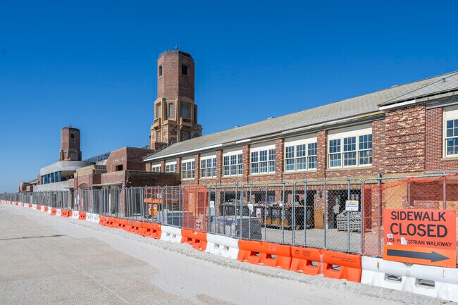
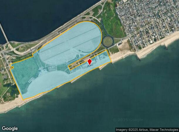
402 Beach 169Th St
16325-0001
Queens
Parkplaygroundpicnicarea
New York
VE
1
3604970378F
149.22 AC
0
JFK/Jamaica
2025
Long Island (New York)
107201
New York-Jersey City-White Plains, NY-NJ
50,000 SF
DEMOGRAPHICS near 402 Beach 169Th St
1 Mile
3 Mile
5 Mile
2024 Total Population
3,453
26,875
236,427
2029 Population
3,354
26,057
219,330
Pop Growth 2024-2029
(2.87%)
(3.04%)
(7.23%)
Average Age
45
46
43
2024 Total Households
1,200
10,991
88,779
HH Growth 2024-2029
(3.17%)
(3.03%)
(7.42%)
Median Household Inc
$136,400
$87,275
$71,875
Avg Household Size
2.80
2.30
2.60
2024 Avg HH Vehicles
2.00
1.00
1.00
Median Home Value
$935,766
$718,093
$701,856
Median Year Built
1948
1961
1955
Nearby Places
Map Layers
Map Styles
 Street
 Aerial
- Restaurants
- Banks
- Shops
- Fitness
- Groceries
PUBLIC TRANSPORTATION
COMMUTER RAIL
Far Rockaway Station (Far Rockaway Branch - Long Island Rail Road)
DRIVE
WALK
Distance
Far Rockaway Station (Far Rockaway Branch - Long Island Rail Road)
15 min
7.8 mi
Inwood Station (Far Rockaway Branch - Long Island Rail Road)
DRIVE
WALK
Distance
Inwood Station (Far Rockaway Branch - Long Island Rail Road)
16 min
9.1 mi
AIRPORT
John F Kennedy International
DRIVE
WALK
Distance
John F Kennedy International
25 min
14.7 mi
LaGuardia
DRIVE
WALK
Distance
LaGuardia
36 min
21.5 mi
Newark Liberty International
DRIVE
WALK
Distance
Newark Liberty International
52 min
31.1 mi
Freight Ports
NY - Red Hook Container Terminal
DRIVE
WALK
Distance
NY - Red Hook Container Terminal
29 min
13.7 mi
Nearby Properties
Address
Land Use
TOTAL SIZE
Lot Size
Zoning
Address
Land Use
TOTAL SIZE
Lot Size
Zoning
100 SF
1,207.35 AC
M1-1
Address
Land Use
TOTAL SIZE
Lot Size
Zoning
65.94 AC
PARKUS
Address
Land Use
TOTAL SIZE
Lot Size
Zoning
200.83 AC
PARK
Address
Land Use
TOTAL SIZE
Lot Size
Zoning
2,000 SF
253.68 AC
R4
Address
Land Use
TOTAL SIZE
Lot Size
Zoning
42.84 AC
PARK
Address
Land Use
TOTAL SIZE
Lot Size
Zoning
407,218 SF
34.48 AC
R4
Address
Land Use
TOTAL SIZE
Lot Size
Zoning
18.71 AC
PARKUS
Address
Land Use
TOTAL SIZE
Lot Size
Zoning
20,000 SF
172.95 AC
PARK
Address
Land Use
TOTAL SIZE
Lot Size
Zoning
1,800 SF
65.66 AC
PARK
Address
Land Use
TOTAL SIZE
Lot Size
Zoning
12,000 SF
81.11 AC
PARK
Address
Land Use
TOTAL SIZE
Lot Size
Zoning
160,315 SF
0.66 AC
R7A
Address
Land Use
TOTAL SIZE
Lot Size
Zoning
72,148 SF
0.44 AC
R6A
Address
Land Use
TOTAL SIZE
Lot Size
Zoning
600 SF
162.63 AC
PARK
Address
Land Use
TOTAL SIZE
Lot Size
Zoning
129,955 SF
0.34 AC
R8
Address
Land Use
TOTAL SIZE
Lot Size
Zoning
119,875 SF
3.16 AC
R4
Address
Land Use
TOTAL SIZE
Lot Size
Zoning
13.76 AC
PARK
Address
Land Use
TOTAL SIZE
Lot Size
Zoning
293,677 SF
4.48 AC
R5
Address
Land Use
TOTAL SIZE
Lot Size
Zoning
292,677 SF
4.90 AC
R5
Address
Land Use
TOTAL SIZE
Lot Size
Zoning
24,000,000 SF
55.42 AC
M1-1
Address
Land Use
TOTAL SIZE
Lot Size
Zoning
290,070 SF
5.29 AC
R5
Address
Land Use
TOTAL SIZE
Lot Size
Zoning
93,023 SF
3.17 AC
R4
Address
Land Use
TOTAL SIZE
Lot Size
Zoning
72,726 SF
2.28 AC
R4
Address
Land Use
TOTAL SIZE
Lot Size
Zoning
48,385 SF
0.45 AC
R6A
Address
Land Use
TOTAL SIZE
Lot Size
Zoning
3.44 AC
PARKUS
Address
Land Use
TOTAL SIZE
Lot Size
Zoning
71,915 SF
1.86 AC
R2
Address
Land Use
TOTAL SIZE
Lot Size
Zoning
2.94 AC
R5
Address
Land Use
TOTAL SIZE
Lot Size
Zoning
79,000 SF
1.38 AC
R4
Address
Land Use
TOTAL SIZE
Lot Size
Zoning
2.45 AC
R4
Address
Land Use
TOTAL SIZE
Lot Size
Zoning
56,000 SF
5.10 AC
M1-1
The World's #1 Commercial Real Estate Marketplace
Connect with us
© 2025 CoStar Group
The information above has been obtained from sources believed reliable. While we do not doubt its accuracy we have not verified it and make no guarantee, warranty or representation about it. It is your responsibility to independently confirm its accuracy and completeness. Any projections, opinions, assumptions, or estimates used are for example only and do not represent the current or future performance of the property. The value of this transaction to you depends on tax and other factors which should be evaluated by your tax, financial, and legal advisors. You and your advisors should conduct a careful, independent investigation of the property to determine to your satisfaction the suitability of the property for your needs.