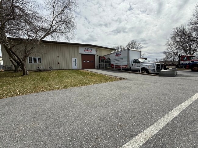
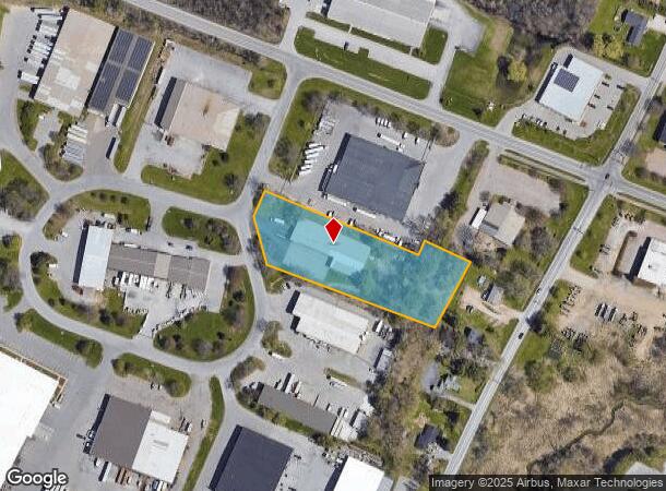
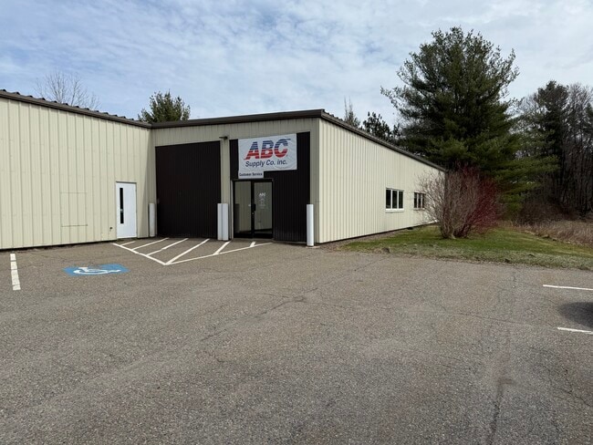
Property Record
402 Boyer Cir, Williston, VT 05495
Current Lease Availabilities
NEARBY LISTINGS FOR SALE OR LEASE
Property Detail
402 Boyer Cir
(241) 07085004000
2.11A/BLDG LOT 3 ADAMS PARK
Commercialnec
Chittenden
X
Vermont
50007C0259D
2.11 AC
0
Vermont North Area
2024
Other Market Areas
003101
Burlington-South Burlington, VT
13,920 SF
DEMOGRAPHICS near 402 Boyer Cir
1 Mile
3 Mile
5 Mile
2024 Total Population
437
21,351
92,635
2029 Population
441
21,647
93,998
Pop Growth 2024-2029
+ 0.92%
+ 1.39%
+ 1.47%
Average Age
41
42
38
2024 Total Households
166
9,321
38,156
HH Growth 2024-2029
+ 1.20%
+ 1.52%
+ 1.59%
Median Household Inc
$121,499
$93,621
$78,917
Avg Household Size
2.50
2.20
2.20
2024 Avg HH Vehicles
2.00
2.00
2.00
Median Home Value
$375,925
$373,702
$382,818
Median Year Built
1970
1988
1979
Nearby Places
Map Layers
Map Styles
 Street
 Aerial
- Restaurants
- Banks
- Shops
- Fitness
- Groceries
PUBLIC TRANSPORTATION
COMMUTER RAIL
DRIVE
WALK
Distance
9 min
4.6 mi
DRIVE
WALK
Distance
13 min
5.4 mi
AIRPORT
Patrick Leahy Burlington International
DRIVE
WALK
Distance
Patrick Leahy Burlington International
18 min
5.8 mi
Plattsburgh International
DRIVE
WALK
Distance
Plattsburgh International
73 min
37.0 mi
Nearby Properties
Address
Land Use
TOTAL SIZE
Lot Size
Zoning
Address
Land Use
TOTAL SIZE
Lot Size
Zoning
227.57 AC
Address
Land Use
TOTAL SIZE
Lot Size
Zoning
Address
Land Use
TOTAL SIZE
Lot Size
Zoning
Address
Land Use
TOTAL SIZE
Lot Size
Zoning
Address
Land Use
TOTAL SIZE
Lot Size
Zoning
Address
Land Use
TOTAL SIZE
Lot Size
Zoning
Address
Land Use
TOTAL SIZE
Lot Size
Zoning
736.20 AC
Address
Land Use
TOTAL SIZE
Lot Size
Zoning
Address
Land Use
TOTAL SIZE
Lot Size
Zoning
52,824 SF
14.43 AC
Address
Land Use
TOTAL SIZE
Lot Size
Zoning
Address
Land Use
TOTAL SIZE
Lot Size
Zoning
235,994 SF
Address
Land Use
TOTAL SIZE
Lot Size
Zoning
54,000 SF
3.98 AC
Address
Land Use
TOTAL SIZE
Lot Size
Zoning
Address
Land Use
TOTAL SIZE
Lot Size
Zoning
3.20 AC
Address
Land Use
TOTAL SIZE
Lot Size
Zoning
Address
Land Use
TOTAL SIZE
Lot Size
Zoning
54,000 SF
5 AC
Address
Land Use
TOTAL SIZE
Lot Size
Zoning
Address
Land Use
TOTAL SIZE
Lot Size
Zoning
Address
Land Use
TOTAL SIZE
Lot Size
Zoning
64,000 SF
68 AC
Address
Land Use
TOTAL SIZE
Lot Size
Zoning
69,120 SF
11.20 AC
Address
Land Use
TOTAL SIZE
Lot Size
Zoning
35,064 SF
3.71 AC
Address
Land Use
TOTAL SIZE
Lot Size
Zoning
78.78 AC
Address
Land Use
TOTAL SIZE
Lot Size
Zoning
Address
Land Use
TOTAL SIZE
Lot Size
Zoning
Address
Land Use
TOTAL SIZE
Lot Size
Zoning
Address
Land Use
TOTAL SIZE
Lot Size
Zoning
Address
Land Use
TOTAL SIZE
Lot Size
Zoning
3.60 AC
Address
Land Use
TOTAL SIZE
Lot Size
Zoning
3,825 SF
44 AC
Address
Land Use
TOTAL SIZE
Lot Size
Zoning
11.20 AC
Address
Land Use
TOTAL SIZE
Lot Size
Zoning
30,000 SF
4.52 AC
The World's #1 Commercial Real Estate Marketplace
Connect with us
© 2025 CoStar Group
The information above has been obtained from sources believed reliable. While we do not doubt its accuracy we have not verified it and make no guarantee, warranty or representation about it. It is your responsibility to independently confirm its accuracy and completeness. Any projections, opinions, assumptions, or estimates used are for example only and do not represent the current or future performance of the property. The value of this transaction to you depends on tax and other factors which should be evaluated by your tax, financial, and legal advisors. You and your advisors should conduct a careful, independent investigation of the property to determine to your satisfaction the suitability of the property for your needs.