Property Record
402 E Anderson St, Idaho Falls, ID 83401
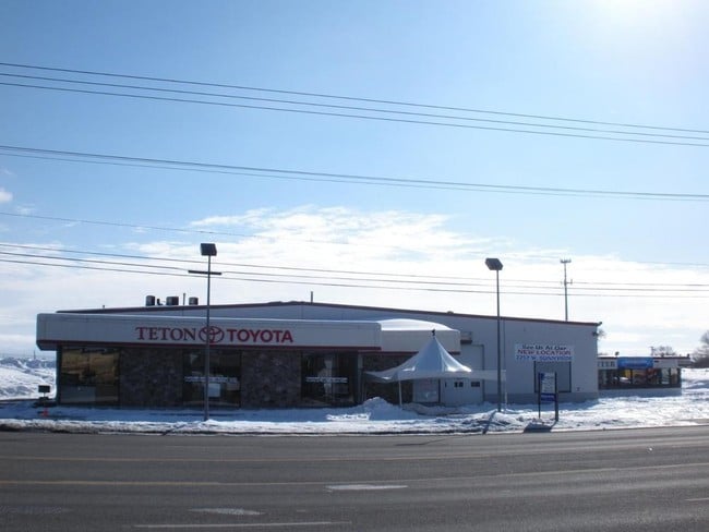

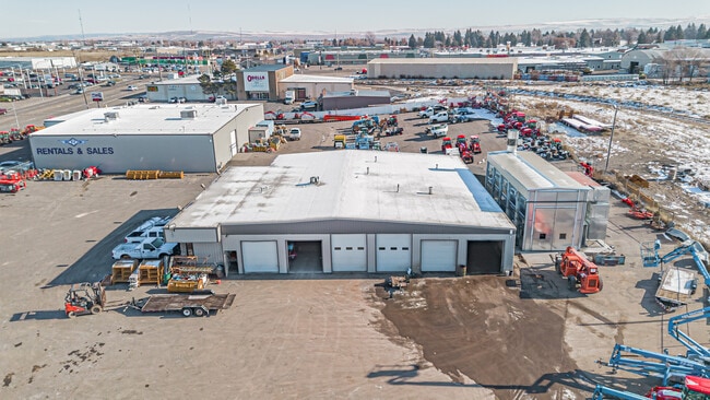
Property Detail
402 E Anderson St
Idaho Falls, ID
152,605 SQ FT BLOCKS 1-2 & R/W, MAYFLOWER NE1/4, SEC 18, T 2N, R 38
RPA1560001000E
Bonneville
Autorepair
Idaho
2025
3.50 AC
2025
Idaho South Area
970700
Other Market Areas
12,852 SF
NEARBY LISTINGS FOR SALE OR LEASE
DEMOGRAPHICS near 402 E Anderson St
1 mile
3 mile
5 mile
2024 Total Population
7,827
60,205
114,343
2029 Population
8,196
63,325
120,556
Pop Growth 2024-2029
+ 4.71%
+ 5.18%
+ 5.43%
Average Age
36
37
37
2024 Total Households
3,011
22,866
40,176
HH Growth 2024-2029
+ 4.82%
+ 5.26%
+ 5.51%
Median Household Inc
$45,147
$63,126
$71,387
Avg Household Size
2.40
2.50
2.80
2024 Avg HH Vehicles
2.00
2.00
2.00
Median Home Value
$180,705
$316,921
$366,727
Median Year Built
1963
1975
1990
Nearby Places
Map Layers
Map Styles
 Street
 Aerial
Transit
 Traffic
 Biking
Places
Listings with unknown addresses are not visible on the map
- Restaurants
- Banks
- Shops
- Fitness
- Groceries
PUBLIC TRANSPORTATION
AIRPORT
Idaho Falls Regional
Drive
Walk
Distance
Idaho Falls Regional
6 min
3.3 mi
SALE & LEASE HISTORY
LISTING DATE
SALE/LEASE

Sep 25, 2016
For Lease
Sep 24, 2016
For Sale
May 23, 2019
For Sale
Feb 22, 2019
For Sale
Dec 01, 2023
For Sale
Nearby Properties
Address
Land Use
TOTAL SIZE
Lot Size
Zoning
Address
Land Use
TOTAL SIZE
Lot Size
Zoning
37,287 SF
9.46 AC
Address
Land Use
TOTAL SIZE
Lot Size
Zoning
267,740 SF
45.91 AC
Address
Land Use
TOTAL SIZE
Lot Size
Zoning
136,343 SF
10 AC
Address
Land Use
TOTAL SIZE
Lot Size
Zoning
4,363 SF
13.28 AC
Address
Land Use
TOTAL SIZE
Lot Size
Zoning
253,387 SF
18.33 AC
R2
Address
Land Use
TOTAL SIZE
Lot Size
Zoning
10,324 SF
8.73 AC
Address
Land Use
TOTAL SIZE
Lot Size
Zoning
220,179 SF
22.20 AC
R2
Address
Land Use
TOTAL SIZE
Lot Size
Zoning
111,649 SF
8.60 AC
Address
Land Use
TOTAL SIZE
Lot Size
Zoning
106,733 SF
2.99 AC
Address
Land Use
TOTAL SIZE
Lot Size
Zoning
61,948 SF
4.51 AC
Address
Land Use
TOTAL SIZE
Lot Size
Zoning
273,545 SF
15.89 AC
R2
Address
Land Use
TOTAL SIZE
Lot Size
Zoning
210,995 SF
24.15 AC
R2
Address
Land Use
TOTAL SIZE
Lot Size
Zoning
27,084 SF
3.69 AC
Address
Land Use
TOTAL SIZE
Lot Size
Zoning
179,244 SF
16.56 AC
Address
Land Use
TOTAL SIZE
Lot Size
Zoning
7,617 SF
4.65 AC
Address
Land Use
TOTAL SIZE
Lot Size
Zoning
61,715 SF
4.12 AC
Address
Land Use
TOTAL SIZE
Lot Size
Zoning
1,472 SF
4.38 AC
Address
Land Use
TOTAL SIZE
Lot Size
Zoning
98,476 SF
0.66 AC
R2
Address
Land Use
TOTAL SIZE
Lot Size
Zoning
163,776 SF
9.56 AC
R2
Address
Land Use
TOTAL SIZE
Lot Size
Zoning
152,632 SF
7.49 AC
R2
Address
Land Use
TOTAL SIZE
Lot Size
Zoning
4,074 SF
10.06 AC
R2
Address
Land Use
TOTAL SIZE
Lot Size
Zoning
91,002 SF
2.70 AC
R2
Address
Land Use
TOTAL SIZE
Lot Size
Zoning
39,458 SF
7.13 AC
Address
Land Use
TOTAL SIZE
Lot Size
Zoning
5,584 SF
6.74 AC
Address
Land Use
TOTAL SIZE
Lot Size
Zoning
140,391 SF
17.57 AC
R2
Address
Land Use
TOTAL SIZE
Lot Size
Zoning
59,941 SF
11.99 AC
Address
Land Use
TOTAL SIZE
Lot Size
Zoning
122,067 SF
10.51 AC
Address
Land Use
TOTAL SIZE
Lot Size
Zoning
216 SF
3.58 AC
Address
Land Use
TOTAL SIZE
Lot Size
Zoning
74,398 SF
1.87 AC
Address
Land Use
TOTAL SIZE
Lot Size
Zoning
133,191 SF
12.38 AC
The World's #1 Commercial Real Estate Marketplace
Connect with us
© 2026 CoStar Group
The information above has been obtained from sources believed reliable. While we do not doubt its accuracy we have not verified it and make no guarantee, warranty or representation about it. It is your responsibility to independently confirm its accuracy and completeness. Any projections, opinions, assumptions, or estimates used are for example only and do not represent the current or future performance of the property. The value of this transaction to you depends on tax and other factors which should be evaluated by your tax, financial, and legal advisors. You and your advisors should conduct a careful, independent investigation of the property to determine to your satisfaction the suitability of the property for your needs.