Property Record
402 E High St, Carlisle, PA 17013
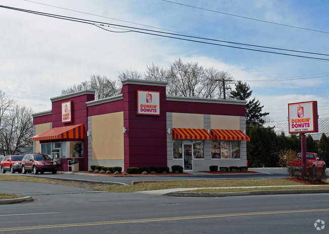

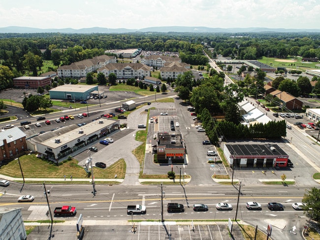
Property Detail
402 E High St
Harrisburg-Carlisle, PA
402 E HIGH STREET L-0001 LOT 1 PB 57 PG 95
03-21-0318-085A
Cumberland
Restaurantdrivein
Pennsylvania
AE The base floodplain where base flood elevations are provided. AE Zones are now used on new format FIRMs instead of A1-A30 Zones.
1
2026
0.99 AC
2026
Harrisburg Area West
012100
Philadelphia
NEARBY LISTINGS FOR SALE OR LEASE
DEMOGRAPHICS near 402 E High St
1 mile
3 mile
5 mile
2025 Total Population
14,940
40,394
56,324
2030 Population
15,749
42,424
59,140
Pop Growth 2025-2030
+ 5.41%
+ 5.03%
+ 5.00%
Average Age
38
41
42
2025 Total Households
6,199
16,384
22,681
HH Growth 2025-2030
+ 5.40%
+ 5.06%
+ 5.07%
Median Household Inc
$50,521
$68,764
$73,369
Avg Household Size
2.10
2.20
2.30
2025 Avg HH Vehicles
1.00
2.00
2.00
Median Home Value
$194,729
$245,300
$264,681
Median Year Built
1950
1971
1974
Nearby Places
Map Layers
Map Styles
 Street
 Aerial
Layers
 Traffic
 Biking
Places
Listings with unknown addresses are not visible on the map
- Restaurants
- Banks
- Shops
- Fitness
- Groceries
PUBLIC TRANSPORTATION
AIRPORT
Harrisburg International
Drive
Walk
Distance
Harrisburg International
42 min
29.8 mi
Freight Ports
Port of Baltimore
Drive
Walk
Distance
Port of Baltimore
118 min
82.1 mi
SALE & LEASE HISTORY
LISTING DATE
SALE/LEASE

Aug 22, 2019
For Sale
Nearby Properties
Address
Land Use
TOTAL SIZE
Lot Size
Zoning
Address
Land Use
TOTAL SIZE
Lot Size
Zoning
213.18 AC
Address
Land Use
TOTAL SIZE
Lot Size
Zoning
Address
Land Use
TOTAL SIZE
Lot Size
Zoning
103.91 AC
Address
Land Use
TOTAL SIZE
Lot Size
Zoning
13.47 AC
Address
Land Use
TOTAL SIZE
Lot Size
Zoning
41.39 AC
Address
Land Use
TOTAL SIZE
Lot Size
Zoning
Address
Land Use
TOTAL SIZE
Lot Size
Zoning
34.64 AC
Address
Land Use
TOTAL SIZE
Lot Size
Zoning
Address
Land Use
TOTAL SIZE
Lot Size
Zoning
68.59 AC
Address
Land Use
TOTAL SIZE
Lot Size
Zoning
73.72 AC
Address
Land Use
TOTAL SIZE
Lot Size
Zoning
56.28 AC
Address
Land Use
TOTAL SIZE
Lot Size
Zoning
69.54 AC
Address
Land Use
TOTAL SIZE
Lot Size
Zoning
54.41 AC
Address
Land Use
TOTAL SIZE
Lot Size
Zoning
1.75 AC
Address
Land Use
TOTAL SIZE
Lot Size
Zoning
38.95 AC
Address
Land Use
TOTAL SIZE
Lot Size
Zoning
0.55 AC
Address
Land Use
TOTAL SIZE
Lot Size
Zoning
45.20 AC
Address
Land Use
TOTAL SIZE
Lot Size
Zoning
7.81 AC
Address
Land Use
TOTAL SIZE
Lot Size
Zoning
55.72 AC
Address
Land Use
TOTAL SIZE
Lot Size
Zoning
31.85 AC
Address
Land Use
TOTAL SIZE
Lot Size
Zoning
31.47 AC
Address
Land Use
TOTAL SIZE
Lot Size
Zoning
36.48 AC
Address
Land Use
TOTAL SIZE
Lot Size
Zoning
6.86 AC
Address
Land Use
TOTAL SIZE
Lot Size
Zoning
36.54 AC
Address
Land Use
TOTAL SIZE
Lot Size
Zoning
26.65 AC
Address
Land Use
TOTAL SIZE
Lot Size
Zoning
28.72 AC
Address
Land Use
TOTAL SIZE
Lot Size
Zoning
40.05 AC
Address
Land Use
TOTAL SIZE
Lot Size
Zoning
2.72 AC
Address
Land Use
TOTAL SIZE
Lot Size
Zoning
33.72 AC
Address
Land Use
TOTAL SIZE
Lot Size
Zoning
7.15 AC
The World's #1 Commercial Real Estate Marketplace
Connect with us
© 2026 CoStar Group
The information above has been obtained from sources believed reliable. While we do not doubt its accuracy we have not verified it and make no guarantee, warranty or representation about it. It is your responsibility to independently confirm its accuracy and completeness. Any projections, opinions, assumptions, or estimates used are for example only and do not represent the current or future performance of the property. The value of this transaction to you depends on tax and other factors which should be evaluated by your tax, financial, and legal advisors. You and your advisors should conduct a careful, independent investigation of the property to determine to your satisfaction the suitability of the property for your needs.