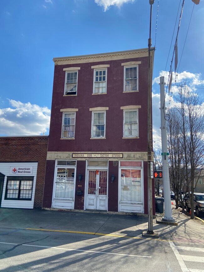
Property Record
402 E Main St, Madison, IN 47250

Property Detail
402 E Main St
Madison, IN
011-03959-00 25.5'X60.2' PT LOT 68 OT 11-129-11 402 E MAIN ST
39-13-02-124-042-000-007
Jefferson
Apartment
Indiana
B and X Area of moderate flood hazard, usually the area between the limits of the 100-year and 500-year floods.
68
2025
0.03 AC
2025
Indiana South Area
966600
Other Market Areas
5,152 SF
NEARBY LISTINGS FOR SALE OR LEASE
DEMOGRAPHICS near 402 E Main St
1 mile
3 mile
5 mile
2025 Total Population
4,153
11,796
21,518
2030 Population
4,185
11,734
21,477
Pop Growth 2025-2030
+ 0.77%
(0.53%)
(0.19%)
Average Age
45
44
41
2025 Total Households
1,893
5,106
8,724
HH Growth 2025-2030
+ 0.74%
(0.61%)
(0.19%)
Median Household Inc
$55,846
$57,851
$57,966
Avg Household Size
2.00
2.10
2.20
2025 Avg HH Vehicles
2.00
2.00
2.00
Median Home Value
$191,819
$189,741
$186,792
Median Year Built
1947
1965
1971
Nearby Places
Map Layers
Map Styles
 Street
 Aerial
Layers
 Traffic
 Biking
Places
Listings with unknown addresses are not visible on the map
- Restaurants
- Banks
- Shops
- Fitness
- Groceries
SALE & LEASE HISTORY
LISTING DATE
SALE/LEASE

Sep 23, 2016
For Sale
May 22, 2024
For Sale
Nearby Properties
Address
Land Use
TOTAL SIZE
Lot Size
Zoning
Address
Land Use
TOTAL SIZE
Lot Size
Zoning
73,680 SF
4.10 AC
Address
Land Use
TOTAL SIZE
Lot Size
Zoning
2,544 SF
2.33 AC
Address
Land Use
TOTAL SIZE
Lot Size
Zoning
69,855 SF
4.70 AC
Address
Land Use
TOTAL SIZE
Lot Size
Zoning
280,486 SF
4.51 AC
Address
Land Use
TOTAL SIZE
Lot Size
Zoning
57,952 SF
1.08 AC
Address
Land Use
TOTAL SIZE
Lot Size
Zoning
49,145 SF
3.73 AC
Address
Land Use
TOTAL SIZE
Lot Size
Zoning
42,966 SF
1.63 AC
Address
Land Use
TOTAL SIZE
Lot Size
Zoning
47,230 SF
0.40 AC
Address
Land Use
TOTAL SIZE
Lot Size
Zoning
7,346 SF
1.28 AC
Address
Land Use
TOTAL SIZE
Lot Size
Zoning
18,550 SF
0.82 AC
Address
Land Use
TOTAL SIZE
Lot Size
Zoning
53,500 SF
5.82 AC
Address
Land Use
TOTAL SIZE
Lot Size
Zoning
14,634 SF
2.43 AC
Address
Land Use
TOTAL SIZE
Lot Size
Zoning
35,200 SF
38.97 AC
Address
Land Use
TOTAL SIZE
Lot Size
Zoning
15,250 SF
4.89 AC
Address
Land Use
TOTAL SIZE
Lot Size
Zoning
4,314 SF
4.67 AC
Address
Land Use
TOTAL SIZE
Lot Size
Zoning
57,282 SF
4.23 AC
Address
Land Use
TOTAL SIZE
Lot Size
Zoning
93,192 SF
0.20 AC
Address
Land Use
TOTAL SIZE
Lot Size
Zoning
135,360 SF
6.09 AC
Address
Land Use
TOTAL SIZE
Lot Size
Zoning
18,240 SF
1.97 AC
Address
Land Use
TOTAL SIZE
Lot Size
Zoning
8,504 SF
1.24 AC
Address
Land Use
TOTAL SIZE
Lot Size
Zoning
6,528 SF
117.38 AC
Address
Land Use
TOTAL SIZE
Lot Size
Zoning
8,816 SF
0.10 AC
Address
Land Use
TOTAL SIZE
Lot Size
Zoning
14,225 SF
2 AC
Address
Land Use
TOTAL SIZE
Lot Size
Zoning
10,125 SF
1.92 AC
Address
Land Use
TOTAL SIZE
Lot Size
Zoning
8,181 SF
1.97 AC
Address
Land Use
TOTAL SIZE
Lot Size
Zoning
8,360 SF
0.15 AC
Address
Land Use
TOTAL SIZE
Lot Size
Zoning
1.14 AC
Address
Land Use
TOTAL SIZE
Lot Size
Zoning
8,352 SF
0.40 AC
Address
Land Use
TOTAL SIZE
Lot Size
Zoning
39,436 SF
1.04 AC
Address
Land Use
TOTAL SIZE
Lot Size
Zoning
24,288 SF
2.48 AC
The World's #1 Commercial Real Estate Marketplace
Connect with us
© 2026 CoStar Group
The information above has been obtained from sources believed reliable. While we do not doubt its accuracy we have not verified it and make no guarantee, warranty or representation about it. It is your responsibility to independently confirm its accuracy and completeness. Any projections, opinions, assumptions, or estimates used are for example only and do not represent the current or future performance of the property. The value of this transaction to you depends on tax and other factors which should be evaluated by your tax, financial, and legal advisors. You and your advisors should conduct a careful, independent investigation of the property to determine to your satisfaction the suitability of the property for your needs.