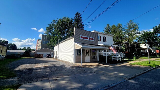
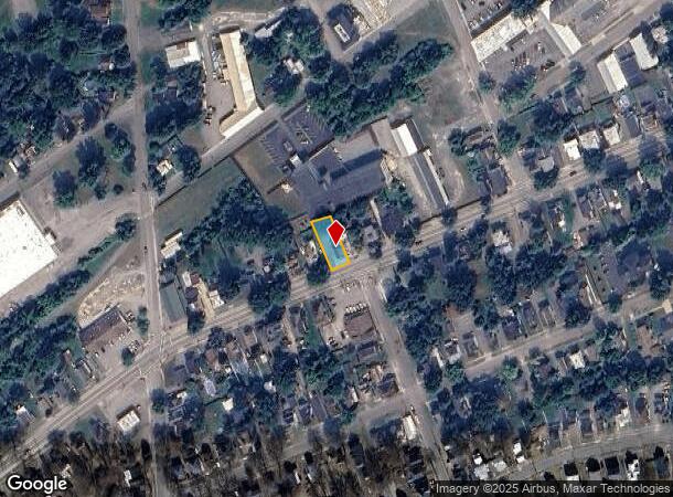
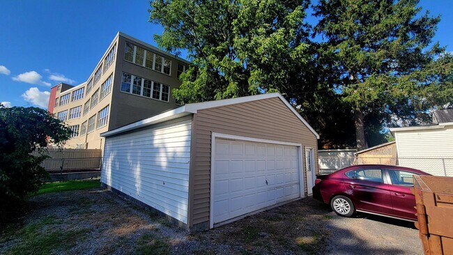
Property Record
402 Lenox Ave, Oneida, NY 13421
NEARBY LISTINGS FOR SALE OR LEASE
Property Detail
402 Lenox Ave
251201-038-022-0001-039-000-0000
INCL 38 22 1 38 TRUST FUND
Storesoffices
Madison
X
New York
3604080002D
39.000
2025
0.16 AC
2024
Madison County
030102
Syracuse
864 SF
Syracuse, NY
DEMOGRAPHICS near 402 Lenox Ave
1 Mile
3 Mile
5 Mile
2024 Total Population
7,334
12,270
22,353
2029 Population
7,159
11,932
21,774
Pop Growth 2024-2029
(2.39%)
(2.75%)
(2.59%)
Average Age
43
43
43
2024 Total Households
3,245
5,263
9,480
HH Growth 2024-2029
(2.56%)
(2.95%)
(2.77%)
Median Household Inc
$46,886
$59,255
$64,430
Avg Household Size
2.20
2.30
2.30
2024 Avg HH Vehicles
1.00
2.00
2.00
Median Home Value
$146,500
$157,566
$165,815
Median Year Built
1948
1953
1955
Nearby Places
Map Layers
Map Styles
 Street
 Aerial
- Restaurants
- Banks
- Shops
- Fitness
- Groceries
PUBLIC TRANSPORTATION
AIRPORT
Syracuse Hancock International
DRIVE
WALK
Distance
Syracuse Hancock International
46 min
32.4 mi
Freight Ports
Albany, NY Port
DRIVE
WALK
Distance
Albany, NY Port
142 min
118.2 mi
SALE & LEASE HISTORY
LISTING DATE
SALE/LEASE

Aug 06, 2024
For Sale
Nearby Properties
Address
Land Use
TOTAL SIZE
Lot Size
Zoning
Address
Land Use
TOTAL SIZE
Lot Size
Zoning
132,207 SF
4.14 AC
CS
Address
Land Use
TOTAL SIZE
Lot Size
Zoning
71,138 SF
14.10 AC
CS
Address
Land Use
TOTAL SIZE
Lot Size
Zoning
26,158 SF
19.28 AC
LI
Address
Land Use
TOTAL SIZE
Lot Size
Zoning
183,164 SF
21.78 AC
C
Address
Land Use
TOTAL SIZE
Lot Size
Zoning
18,912 SF
11.21 AC
Address
Land Use
TOTAL SIZE
Lot Size
Zoning
2,418 SF
55.37 AC
R1
Address
Land Use
TOTAL SIZE
Lot Size
Zoning
137,443 SF
26.45 AC
C
Address
Land Use
TOTAL SIZE
Lot Size
Zoning
29,762 SF
6.75 AC
C
Address
Land Use
TOTAL SIZE
Lot Size
Zoning
Address
Land Use
TOTAL SIZE
Lot Size
Zoning
215,981 SF
12.90 AC
C
Address
Land Use
TOTAL SIZE
Lot Size
Zoning
49,029 SF
12 AC
CS
Address
Land Use
TOTAL SIZE
Lot Size
Zoning
19,251 SF
23.72 AC
LI
Address
Land Use
TOTAL SIZE
Lot Size
Zoning
Address
Land Use
TOTAL SIZE
Lot Size
Zoning
61,969 SF
2.15 AC
C
Address
Land Use
TOTAL SIZE
Lot Size
Zoning
109,750 SF
12.98 AC
C
Address
Land Use
TOTAL SIZE
Lot Size
Zoning
82,953 SF
1.43 AC
C
Address
Land Use
TOTAL SIZE
Lot Size
Zoning
63,239 SF
17.35 AC
Address
Land Use
TOTAL SIZE
Lot Size
Zoning
56,914 SF
3.83 AC
C
Address
Land Use
TOTAL SIZE
Lot Size
Zoning
205,242 SF
46.75 AC
Address
Land Use
TOTAL SIZE
Lot Size
Zoning
532 SF
20.48 AC
CS
Address
Land Use
TOTAL SIZE
Lot Size
Zoning
17,600 SF
2.76 AC
R2
Address
Land Use
TOTAL SIZE
Lot Size
Zoning
4.66 AC
C
Address
Land Use
TOTAL SIZE
Lot Size
Zoning
29,848 SF
2.78 AC
C
Address
Land Use
TOTAL SIZE
Lot Size
Zoning
33,675 SF
6.50 AC
01 - NOT Z
Address
Land Use
TOTAL SIZE
Lot Size
Zoning
33,675 SF
6.50 AC
01 - NOT Z
Address
Land Use
TOTAL SIZE
Lot Size
Zoning
33,828 SF
5.52 AC
C
Address
Land Use
TOTAL SIZE
Lot Size
Zoning
27,032 SF
4.68 AC
C
Address
Land Use
TOTAL SIZE
Lot Size
Zoning
21,072 SF
1.38 AC
DC
Address
Land Use
TOTAL SIZE
Lot Size
Zoning
17,297 SF
5.30 AC
C
Address
Land Use
TOTAL SIZE
Lot Size
Zoning
105,000 SF
1.52 AC
The World's #1 Commercial Real Estate Marketplace
Connect with us
© 2026 CoStar Group
The information above has been obtained from sources believed reliable. While we do not doubt its accuracy we have not verified it and make no guarantee, warranty or representation about it. It is your responsibility to independently confirm its accuracy and completeness. Any projections, opinions, assumptions, or estimates used are for example only and do not represent the current or future performance of the property. The value of this transaction to you depends on tax and other factors which should be evaluated by your tax, financial, and legal advisors. You and your advisors should conduct a careful, independent investigation of the property to determine to your satisfaction the suitability of the property for your needs.