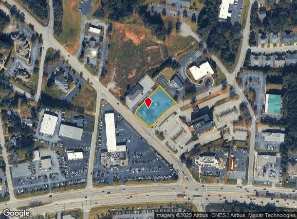
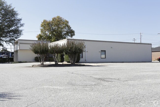
Property Record
402 Memorial Drive Ext, Greer, SC 29651

NEARBY LISTINGS FOR SALE OR LEASE
Property Detail
402 Memorial Drive Ext
Greenville-Anderson-Mauldin, SC
John E Walton
G018.00-05-007.15
MAP G018.00; 1
Medicalbuilding
Greenville
X
South Carolina
45045C0353F
007.15
2025
0.90 AC
2024
Greer/Taylors
002507
Greenville/Spartanburg
DEMOGRAPHICS near 402 Memorial Drive Ext
1 Mile
3 Mile
5 Mile
2024 Total Population
6,770
38,764
85,709
2029 Population
7,488
43,136
95,238
Pop Growth 2024-2029
+ 10.61%
+ 11.28%
+ 11.12%
Average Age
41
40
40
2024 Total Households
2,923
15,702
33,410
HH Growth 2024-2029
+ 10.71%
+ 11.37%
+ 11.21%
Median Household Inc
$55,346
$56,038
$67,559
Avg Household Size
2.30
2.40
2.50
2024 Avg HH Vehicles
2.00
2.00
2.00
Median Home Value
$208,006
$207,030
$231,242
Median Year Built
1982
1991
1994
Nearby Places
Map Layers
Map Styles
 Street
 Aerial
- Restaurants
- Banks
- Shops
- Fitness
- Groceries
PUBLIC TRANSPORTATION
AIRPORT
Greenville Spartanburg International
DRIVE
WALK
Distance
Greenville Spartanburg International
10 min
4.9 mi
Asheville Regional
DRIVE
WALK
Distance
Asheville Regional
66 min
47.9 mi
Nearby Properties
Address
Land Use
TOTAL SIZE
Lot Size
Zoning
Address
Land Use
TOTAL SIZE
Lot Size
Zoning
5.07 AC
C2
Address
Land Use
TOTAL SIZE
Lot Size
Zoning
14.20 AC
UNZONED
Address
Land Use
TOTAL SIZE
Lot Size
Zoning
13.25 AC
I1
Address
Land Use
TOTAL SIZE
Lot Size
Zoning
0.42 AC
OD
Address
Land Use
TOTAL SIZE
Lot Size
Zoning
8.22 AC
I1
Address
Land Use
TOTAL SIZE
Lot Size
Zoning
1.05 AC
S1
Address
Land Use
TOTAL SIZE
Lot Size
Zoning
1.90 AC
I1
Address
Land Use
TOTAL SIZE
Lot Size
Zoning
6.81 AC
RM
Address
Land Use
TOTAL SIZE
Lot Size
Zoning
710,705 SF
34.03 AC
Address
Land Use
TOTAL SIZE
Lot Size
Zoning
91,927 SF
21.14 AC
Address
Land Use
TOTAL SIZE
Lot Size
Zoning
10.20 AC
S1
Address
Land Use
TOTAL SIZE
Lot Size
Zoning
16,592 SF
15.43 AC
Address
Land Use
TOTAL SIZE
Lot Size
Zoning
5.23 AC
I1
Address
Land Use
TOTAL SIZE
Lot Size
Zoning
5.73 AC
C1
Address
Land Use
TOTAL SIZE
Lot Size
Zoning
34.30 AC
UNZONED
Address
Land Use
TOTAL SIZE
Lot Size
Zoning
14.33 AC
I1
Address
Land Use
TOTAL SIZE
Lot Size
Zoning
22.35 AC
R20
Address
Land Use
TOTAL SIZE
Lot Size
Zoning
532 SF
72.61 AC
I1
Address
Land Use
TOTAL SIZE
Lot Size
Zoning
4.07 AC
OD
Address
Land Use
TOTAL SIZE
Lot Size
Zoning
1,111,000 SF
Address
Land Use
TOTAL SIZE
Lot Size
Zoning
6.90 AC
I1
Address
Land Use
TOTAL SIZE
Lot Size
Zoning
19.02 AC
RRROW
Address
Land Use
TOTAL SIZE
Lot Size
Zoning
7,990 SF
1.62 AC
Address
Land Use
TOTAL SIZE
Lot Size
Zoning
11.70 AC
C2
Address
Land Use
TOTAL SIZE
Lot Size
Zoning
7.12 AC
R15
Address
Land Use
TOTAL SIZE
Lot Size
Zoning
5.47 AC
RM1
Address
Land Use
TOTAL SIZE
Lot Size
Zoning
5.15 AC
R15
Address
Land Use
TOTAL SIZE
Lot Size
Zoning
1.40 AC
C2
Address
Land Use
TOTAL SIZE
Lot Size
Zoning
3.56 AC
OD
Address
Land Use
TOTAL SIZE
Lot Size
Zoning
13,344 SF
125 AC
The World's #1 Commercial Real Estate Marketplace
Connect with us
© 2025 CoStar Group
The information above has been obtained from sources believed reliable. While we do not doubt its accuracy we have not verified it and make no guarantee, warranty or representation about it. It is your responsibility to independently confirm its accuracy and completeness. Any projections, opinions, assumptions, or estimates used are for example only and do not represent the current or future performance of the property. The value of this transaction to you depends on tax and other factors which should be evaluated by your tax, financial, and legal advisors. You and your advisors should conduct a careful, independent investigation of the property to determine to your satisfaction the suitability of the property for your needs.