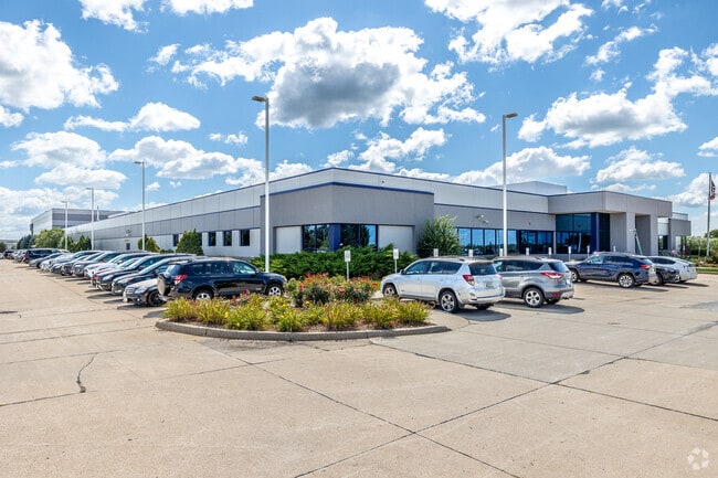
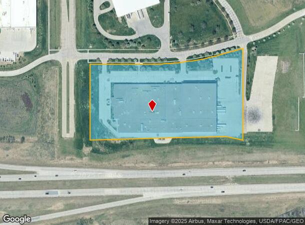
Property Record
4020 Gannett Ave, Des Moines, IA 50321
NEARBY LISTINGS FOR SALE OR LEASE
Property Detail
4020 Gannett Ave
Des Moines-West Des Moines, IA
Airport Business Park Plat 1
120-00004005005
N OF RELOCATED HWY 5 LOTS 5 & 6 AIRPORT BUSINESS PARK PLAT NO. 1
Lightindustrial
Polk
X
Iowa
19153C0345F
5,6
2024
9.41 AC
2025
South
004701
Des Moines
161,788 SF
DEMOGRAPHICS near 4020 Gannett Ave
1 Mile
3 Mile
5 Mile
2024 Total Population
778
30,681
86,405
2029 Population
850
32,851
91,296
Pop Growth 2024-2029
+ 9.25%
+ 7.07%
+ 5.66%
Average Age
36
38
38
2024 Total Households
277
12,144
35,544
HH Growth 2024-2029
+ 9.39%
+ 7.10%
+ 5.74%
Median Household Inc
$89,453
$75,234
$66,904
Avg Household Size
2.80
2.40
2.40
2024 Avg HH Vehicles
2.00
2.00
2.00
Median Home Value
$194,573
$201,068
$188,323
Median Year Built
1984
1979
1974
Nearby Places
Map Layers
Map Styles
 Street
 Aerial
- Restaurants
- Banks
- Shops
- Fitness
- Groceries
PUBLIC TRANSPORTATION
AIRPORT
Des Moines International
DRIVE
WALK
Distance
Des Moines International
10 min
4.3 mi
Freight Ports
Port Milwaukee
DRIVE
WALK
Distance
Port Milwaukee
429 min
381.3 mi
Nearby Properties
Address
Land Use
TOTAL SIZE
Lot Size
Zoning
Address
Land Use
TOTAL SIZE
Lot Size
Zoning
351,427 SF
57.41 AC
Address
Land Use
TOTAL SIZE
Lot Size
Zoning
496,782 SF
59.32 AC
Address
Land Use
TOTAL SIZE
Lot Size
Zoning
283,760 SF
27.19 AC
Address
Land Use
TOTAL SIZE
Lot Size
Zoning
283,760 SF
14.96 AC
Address
Land Use
TOTAL SIZE
Lot Size
Zoning
227,640 SF
19.48 AC
Address
Land Use
TOTAL SIZE
Lot Size
Zoning
Address
Land Use
TOTAL SIZE
Lot Size
Zoning
286,504 SF
23.31 AC
Address
Land Use
TOTAL SIZE
Lot Size
Zoning
397,938 SF
27.97 AC
PUD
Address
Land Use
TOTAL SIZE
Lot Size
Zoning
302,800 SF
20.85 AC
Address
Land Use
TOTAL SIZE
Lot Size
Zoning
203,710 SF
26.88 AC
Address
Land Use
TOTAL SIZE
Lot Size
Zoning
298,716 SF
18.90 AC
PUD
Address
Land Use
TOTAL SIZE
Lot Size
Zoning
93,889 SF
17.07 AC
Address
Land Use
TOTAL SIZE
Lot Size
Zoning
61,320 SF
8.13 AC
Address
Land Use
TOTAL SIZE
Lot Size
Zoning
260,420 SF
18.17 AC
R-3
Address
Land Use
TOTAL SIZE
Lot Size
Zoning
107,550 SF
7.30 AC
Address
Land Use
TOTAL SIZE
Lot Size
Zoning
131,361 SF
7.50 AC
Address
Land Use
TOTAL SIZE
Lot Size
Zoning
106,470 SF
0.56 AC
Address
Land Use
TOTAL SIZE
Lot Size
Zoning
191,668 SF
8.27 AC
R-6
Address
Land Use
TOTAL SIZE
Lot Size
Zoning
149,564 SF
22.29 AC
PUD
Address
Land Use
TOTAL SIZE
Lot Size
Zoning
86,789 SF
15.23 AC
Address
Land Use
TOTAL SIZE
Lot Size
Zoning
1,760 SF
15.58 AC
Address
Land Use
TOTAL SIZE
Lot Size
Zoning
135,016 SF
25.08 AC
M-1
Address
Land Use
TOTAL SIZE
Lot Size
Zoning
74,210 SF
39.21 AC
Address
Land Use
TOTAL SIZE
Lot Size
Zoning
123,398 SF
8.62 AC
Address
Land Use
TOTAL SIZE
Lot Size
Zoning
82,044 SF
2.91 AC
Address
Land Use
TOTAL SIZE
Lot Size
Zoning
38,950 SF
9.99 AC
RM
Address
Land Use
TOTAL SIZE
Lot Size
Zoning
144,828 SF
8.34 AC
R-3
Address
Land Use
TOTAL SIZE
Lot Size
Zoning
23,662 SF
15.89 AC
PBP
Address
Land Use
TOTAL SIZE
Lot Size
Zoning
121,200 SF
10.32 AC
C-2
The World's #1 Commercial Real Estate Marketplace
Connect with us
© 2026 CoStar Group
The information above has been obtained from sources believed reliable. While we do not doubt its accuracy we have not verified it and make no guarantee, warranty or representation about it. It is your responsibility to independently confirm its accuracy and completeness. Any projections, opinions, assumptions, or estimates used are for example only and do not represent the current or future performance of the property. The value of this transaction to you depends on tax and other factors which should be evaluated by your tax, financial, and legal advisors. You and your advisors should conduct a careful, independent investigation of the property to determine to your satisfaction the suitability of the property for your needs.