Property Record
4020 Highway 365, Port Arthur, TX 77642
NEARBY LISTINGS FOR SALE OR LEASE
-
-
View all Port Arthur listings for sale on LoopNet.com
Property Detail
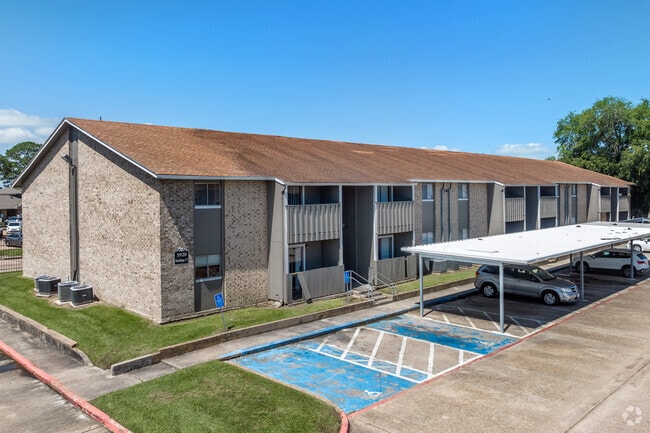
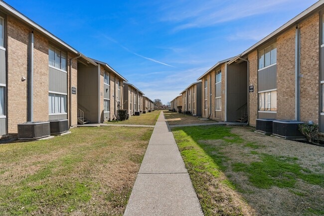
4020 Highway 365
Beaumont/Port Arthur
Palco - Ned.
Beaumont-Port Arthur, TX
Jefferson
049401-000-002600-00000
Texas
Apartment
14.15 AC
303,400 SF
Port Arthur/Groves
DEMOGRAPHICS near 4020 Highway 365
1 Mile
3 Mile
5 Mile
2024 Total Population
12,315
43,260
81,695
2029 Population
11,828
41,760
79,083
Pop Growth 2024-2029
(3.95%)
(3.47%)
(3.20%)
Average Age
38
39
38
2024 Total Households
5,243
17,541
30,251
HH Growth 2024-2029
(4.27%)
(3.64%)
(3.45%)
Median Household Inc
$57,344
$74,262
$67,021
Avg Household Size
2.30
2.40
2.50
2024 Avg HH Vehicles
2.00
2.00
2.00
Median Home Value
$166,886
$195,474
$169,766
Median Year Built
1977
1976
1972
Nearby Places
Map Layers
Map Styles
 Street
 Aerial
- Restaurants
- Banks
- Shops
- Fitness
- Groceries
Nearby Properties
Address
Land Use
TOTAL SIZE
Lot Size
Zoning
Address
Land Use
TOTAL SIZE
Lot Size
Zoning
351,556 SF
18.92 AC
Address
Land Use
TOTAL SIZE
Lot Size
Zoning
284,108 SF
25 AC
Address
Land Use
TOTAL SIZE
Lot Size
Zoning
279,375 SF
18.94 AC
Address
Land Use
TOTAL SIZE
Lot Size
Zoning
235,864 SF
12.21 AC
Address
Land Use
TOTAL SIZE
Lot Size
Zoning
221,714 SF
13.91 AC
Address
Land Use
TOTAL SIZE
Lot Size
Zoning
24,763 SF
2.74 AC
Address
Land Use
TOTAL SIZE
Lot Size
Zoning
67,048 SF
5.40 AC
Address
Land Use
TOTAL SIZE
Lot Size
Zoning
136,295 SF
5.30 AC
Address
Land Use
TOTAL SIZE
Lot Size
Zoning
47,841 SF
8 AC
Address
Land Use
TOTAL SIZE
Lot Size
Zoning
7,296 SF
59.41 AC
Address
Land Use
TOTAL SIZE
Lot Size
Zoning
16,200 SF
2.09 AC
Address
Land Use
TOTAL SIZE
Lot Size
Zoning
63,836 SF
0.64 AC
Address
Land Use
TOTAL SIZE
Lot Size
Zoning
203,821 SF
19.68 AC
Address
Land Use
TOTAL SIZE
Lot Size
Zoning
129,495 SF
7.23 AC
Address
Land Use
TOTAL SIZE
Lot Size
Zoning
127,946 SF
7.72 AC
Address
Land Use
TOTAL SIZE
Lot Size
Zoning
17,414 SF
2.20 AC
Address
Land Use
TOTAL SIZE
Lot Size
Zoning
110,499 SF
4.80 AC
Address
Land Use
TOTAL SIZE
Lot Size
Zoning
18,795 SF
2.50 AC
Address
Land Use
TOTAL SIZE
Lot Size
Zoning
628,811 SF
38.48 AC
Address
Land Use
TOTAL SIZE
Lot Size
Zoning
79,096 SF
9.09 AC
Address
Land Use
TOTAL SIZE
Lot Size
Zoning
185,832 SF
10.08 AC
Address
Land Use
TOTAL SIZE
Lot Size
Zoning
55,953 SF
1.87 AC
Address
Land Use
TOTAL SIZE
Lot Size
Zoning
81,675 SF
4.28 AC
Address
Land Use
TOTAL SIZE
Lot Size
Zoning
62,233 SF
6.94 AC
Address
Land Use
TOTAL SIZE
Lot Size
Zoning
121,752 SF
9.88 AC
Address
Land Use
TOTAL SIZE
Lot Size
Zoning
183,963 SF
23.46 AC
Address
Land Use
TOTAL SIZE
Lot Size
Zoning
86,567 SF
5 AC
Address
Land Use
TOTAL SIZE
Lot Size
Zoning
45,252 SF
13.70 AC
Address
Land Use
TOTAL SIZE
Lot Size
Zoning
132,007 SF
1.27 AC
The World's #1 Commercial Real Estate Marketplace
Connect with us
© 2025 CoStar Group
The information above has been obtained from sources believed reliable. While we do not doubt its accuracy we have not verified it and make no guarantee, warranty or representation about it. It is your responsibility to independently confirm its accuracy and completeness. Any projections, opinions, assumptions, or estimates used are for example only and do not represent the current or future performance of the property. The value of this transaction to you depends on tax and other factors which should be evaluated by your tax, financial, and legal advisors. You and your advisors should conduct a careful, independent investigation of the property to determine to your satisfaction the suitability of the property for your needs.