Property Record
4020 N Roxboro St, Durham, NC 27704
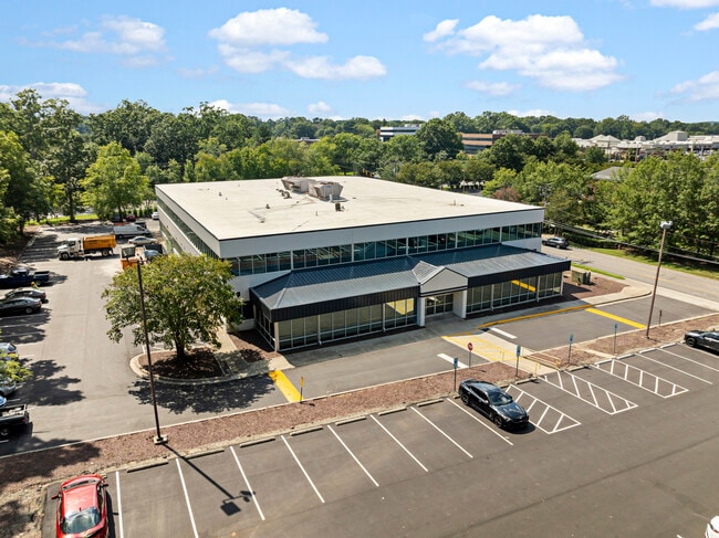


This Property Is For Sale
Current Lease Availabilities
Property Detail
4020 N Roxboro St
172252
ROXBORO OFFICE CONDOMINIUN/COMMON ELEMENTS PL:13-339
Officecondo
Durham
OI
North Carolina
B and X Area of moderate flood hazard, usually the area between the limits of the 100-year and 500-year floods.
1a
2025
3.35 AC
2025
North Durham
001709
Raleigh/Durham
41,828 SF
Durham-Chapel Hill, NC
NEARBY LISTINGS FOR SALE OR LEASE
DEMOGRAPHICS near 4020 N Roxboro St
1 mile
3 mile
5 mile
2025 Total Population
9,053
62,349
151,352
2030 Population
9,563
65,813
160,329
Pop Growth 2025-2030
+ 5.63%
+ 5.56%
+ 5.93%
Average Age
38
39
38
2025 Total Households
3,572
26,419
61,675
HH Growth 2025-2030
+ 5.80%
+ 5.81%
+ 6.38%
Median Household Inc
$54,291
$71,535
$68,387
Avg Household Size
2.40
2.30
2.30
2025 Avg HH Vehicles
1.00
2.00
2.00
Median Home Value
$345,953
$392,732
$390,669
Median Year Built
1987
1982
1983
Nearby Places
Map Layers
Map Styles
 Street
 Aerial
Layers
 Traffic
 Biking
Places
Listings with unknown addresses are not visible on the map
- Restaurants
- Banks
- Shops
- Fitness
- Groceries
PUBLIC TRANSPORTATION
COMMUTER RAIL
Drive
Walk
Distance
10 min
4.0 mi
AIRPORT
Raleigh-Durham International
Drive
Walk
Distance
Raleigh-Durham International
28 min
16.1 mi
Nearby Properties
Address
Land Use
TOTAL SIZE
Lot Size
Zoning
Address
Land Use
TOTAL SIZE
Lot Size
Zoning
749,544 SF
100.49 AC
OI,RS-8
Address
Land Use
TOTAL SIZE
Lot Size
Zoning
26,512 SF
6.40 AC
CD-C
Address
Land Use
TOTAL SIZE
Lot Size
Zoning
758,666 SF
99.64 AC
PDR 2.000
Address
Land Use
TOTAL SIZE
Lot Size
Zoning
24,741 SF
5.67 AC
CD-S1
Address
Land Use
TOTAL SIZE
Lot Size
Zoning
3.20 AC
CD-S1
Address
Land Use
TOTAL SIZE
Lot Size
Zoning
90,416 SF
3.87 AC
CD-S1
Address
Land Use
TOTAL SIZE
Lot Size
Zoning
12,440 SF
36.51 AC
PDR 2.000
Address
Land Use
TOTAL SIZE
Lot Size
Zoning
218,946 SF
1.91 AC
DD-S1
Address
Land Use
TOTAL SIZE
Lot Size
Zoning
368,569 SF
2.77 AC
Address
Land Use
TOTAL SIZE
Lot Size
Zoning
250,392 SF
16.67 AC
DD-S2
Address
Land Use
TOTAL SIZE
Lot Size
Zoning
485,295 SF
27.35 AC
RS-8
Address
Land Use
TOTAL SIZE
Lot Size
Zoning
69.37 AC
IL
Address
Land Use
TOTAL SIZE
Lot Size
Zoning
6,753 SF
22.99 AC
OI(D)
Address
Land Use
TOTAL SIZE
Lot Size
Zoning
256,975 SF
7.42 AC
CD-C
Address
Land Use
TOTAL SIZE
Lot Size
Zoning
3.61 AC
DD-S1
Address
Land Use
TOTAL SIZE
Lot Size
Zoning
166,866 SF
76.52 AC
RS-10
Address
Land Use
TOTAL SIZE
Lot Size
Zoning
297,910 SF
39.63 AC
RS-20
Address
Land Use
TOTAL SIZE
Lot Size
Zoning
12,468 SF
13.33 AC
RU-M(D)
Address
Land Use
TOTAL SIZE
Lot Size
Zoning
97.24 AC
UC(D)
Address
Land Use
TOTAL SIZE
Lot Size
Zoning
6,822 SF
24.64 AC
PDR 2.000
Address
Land Use
TOTAL SIZE
Lot Size
Zoning
354,480 SF
34.53 AC
IL
Address
Land Use
TOTAL SIZE
Lot Size
Zoning
4,644 SF
19.04 AC
RU-M
Address
Land Use
TOTAL SIZE
Lot Size
Zoning
15,720 SF
16.18 AC
PDR 10.000
Address
Land Use
TOTAL SIZE
Lot Size
Zoning
19,769 SF
9.12 AC
OI(D)
Address
Land Use
TOTAL SIZE
Lot Size
Zoning
7,056 SF
25.68 AC
RS-M
Address
Land Use
TOTAL SIZE
Lot Size
Zoning
117,537 SF
4.39 AC
CD-P(N)
Address
Land Use
TOTAL SIZE
Lot Size
Zoning
6,936 SF
11.42 AC
PDR 2.000
Address
Land Use
TOTAL SIZE
Lot Size
Zoning
176,751 SF
17.77 AC
OI
Address
Land Use
TOTAL SIZE
Lot Size
Zoning
8,824 SF
15.96 AC
RS-M
Address
Land Use
TOTAL SIZE
Lot Size
Zoning
15,140 SF
19.79 AC
RS-M
The World's #1 Commercial Real Estate Marketplace
Connect with us
© 2026 CoStar Group
The information above has been obtained from sources believed reliable. While we do not doubt its accuracy we have not verified it and make no guarantee, warranty or representation about it. It is your responsibility to independently confirm its accuracy and completeness. Any projections, opinions, assumptions, or estimates used are for example only and do not represent the current or future performance of the property. The value of this transaction to you depends on tax and other factors which should be evaluated by your tax, financial, and legal advisors. You and your advisors should conduct a careful, independent investigation of the property to determine to your satisfaction the suitability of the property for your needs.