Property Record
4020 Nc Highway 8, Lexington, NC 27292
NEARBY LISTINGS FOR SALE OR LEASE
-
-
View all Lexington listings for sale on LoopNet.com
Property Detail
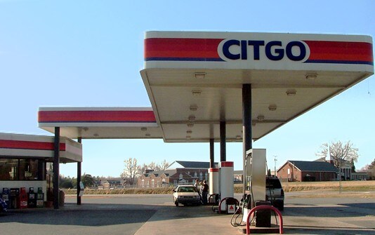
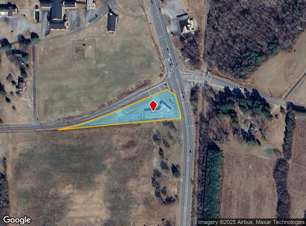
4020 Nc Highway 8
06-008-0-000-0008-A-0-0
Survey For Sam Everhart
Conveniencestore
L8A BK2199-1867 JR OR HM RD
X
Davidson
3710672300J
North Carolina
2025
1.06 AC
2025
South Davidson County
061803
Greensboro/Winston-Salem
4,517 SF
Winston-Salem, NC
DEMOGRAPHICS near 4020 Nc Highway 8
1 Mile
3 Mile
5 Mile
2024 Total Population
762
7,880
32,102
2029 Population
799
8,314
34,022
Pop Growth 2024-2029
+ 4.86%
+ 5.51%
+ 5.98%
Average Age
41
42
41
2024 Total Households
296
3,152
12,909
HH Growth 2024-2029
+ 5.07%
+ 5.46%
+ 5.90%
Median Household Inc
$52,083
$49,700
$44,433
Avg Household Size
2.50
2.40
2.40
2024 Avg HH Vehicles
2.00
2.00
2.00
Median Home Value
$155,172
$163,576
$162,482
Median Year Built
1981
1980
1978
Nearby Places
Map Layers
Map Styles
 Street
 Aerial
- Restaurants
- Banks
- Shops
- Fitness
- Groceries
PUBLIC TRANSPORTATION
AIRPORT
Piedmont Triad International
DRIVE
WALK
Distance
Piedmont Triad International
53 min
41.6 mi
Freight Ports
Port of Wilmington
DRIVE
WALK
Distance
Port of Wilmington
258 min
215.2 mi
Nearby Properties
Address
Land Use
TOTAL SIZE
Lot Size
Zoning
Address
Land Use
TOTAL SIZE
Lot Size
Zoning
4,622 SF
246.40 AC
I
Address
Land Use
TOTAL SIZE
Lot Size
Zoning
943,340 SF
202.76 AC
RA1
Address
Land Use
TOTAL SIZE
Lot Size
Zoning
22,560 SF
204.19 AC
I
Address
Land Use
TOTAL SIZE
Lot Size
Zoning
3,156 SF
332.28 AC
HI
Address
Land Use
TOTAL SIZE
Lot Size
Zoning
207,185 SF
29.84 AC
B
Address
Land Use
TOTAL SIZE
Lot Size
Zoning
43,008 SF
25.21 AC
B
Address
Land Use
TOTAL SIZE
Lot Size
Zoning
142,700 SF
18.21 AC
B
Address
Land Use
TOTAL SIZE
Lot Size
Zoning
101,475 SF
108.36 AC
I
Address
Land Use
TOTAL SIZE
Lot Size
Zoning
6,000 SF
33.27 AC
HI
Address
Land Use
TOTAL SIZE
Lot Size
Zoning
15,192 SF
117.89 AC
SN
Address
Land Use
TOTAL SIZE
Lot Size
Zoning
29,313 SF
27.73 AC
RA2
Address
Land Use
TOTAL SIZE
Lot Size
Zoning
90,678 SF
39.70 AC
RA1
Address
Land Use
TOTAL SIZE
Lot Size
Zoning
46,562 SF
1.73 AC
B
Address
Land Use
TOTAL SIZE
Lot Size
Zoning
5,490 SF
212.79 AC
RA1
Address
Land Use
TOTAL SIZE
Lot Size
Zoning
1,160 SF
28.40 AC
TN
Address
Land Use
TOTAL SIZE
Lot Size
Zoning
214,592 SF
20.01 AC
I
Address
Land Use
TOTAL SIZE
Lot Size
Zoning
14,148 SF
3.34 AC
B
Address
Land Use
TOTAL SIZE
Lot Size
Zoning
201,600 SF
9.90 AC
I
Address
Land Use
TOTAL SIZE
Lot Size
Zoning
131,250 SF
14.30 AC
I
Address
Land Use
TOTAL SIZE
Lot Size
Zoning
59,281 SF
4.34 AC
B
Address
Land Use
TOTAL SIZE
Lot Size
Zoning
49,552 SF
3.33 AC
B
Address
Land Use
TOTAL SIZE
Lot Size
Zoning
104,230 SF
62.20 AC
I
Address
Land Use
TOTAL SIZE
Lot Size
Zoning
19,137 SF
2.01 AC
B
Address
Land Use
TOTAL SIZE
Lot Size
Zoning
32,272 SF
10 AC
TN
Address
Land Use
TOTAL SIZE
Lot Size
Zoning
91,618 SF
23.25 AC
RA2
Address
Land Use
TOTAL SIZE
Lot Size
Zoning
157,650 SF
28.11 AC
LI
Address
Land Use
TOTAL SIZE
Lot Size
Zoning
11,316 SF
9.83 AC
TN
Address
Land Use
TOTAL SIZE
Lot Size
Zoning
115,838 SF
57.83 AC
I
Address
Land Use
TOTAL SIZE
Lot Size
Zoning
19,536 SF
4 AC
B
Address
Land Use
TOTAL SIZE
Lot Size
Zoning
18,073 SF
1.73 AC
B
The World's #1 Commercial Real Estate Marketplace
Connect with us
© 2025 CoStar Group
The information above has been obtained from sources believed reliable. While we do not doubt its accuracy we have not verified it and make no guarantee, warranty or representation about it. It is your responsibility to independently confirm its accuracy and completeness. Any projections, opinions, assumptions, or estimates used are for example only and do not represent the current or future performance of the property. The value of this transaction to you depends on tax and other factors which should be evaluated by your tax, financial, and legal advisors. You and your advisors should conduct a careful, independent investigation of the property to determine to your satisfaction the suitability of the property for your needs.