Property Record
4020 Pelham Ct, Greer, SC 29650

Save to a Folder
{{folder.Name}}
{{folder.ListingIds.length}} Properties
{{folder.ListingIds.length}} Property
Create a New Folder
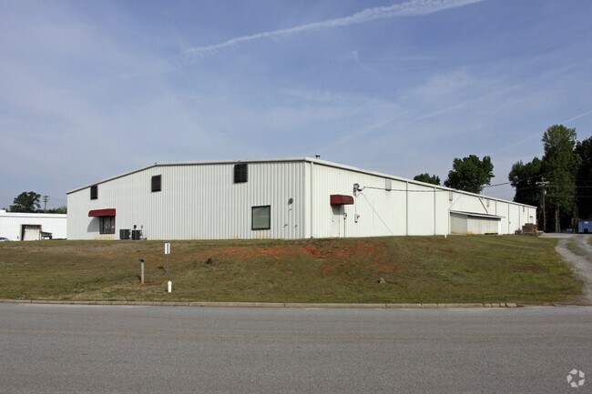
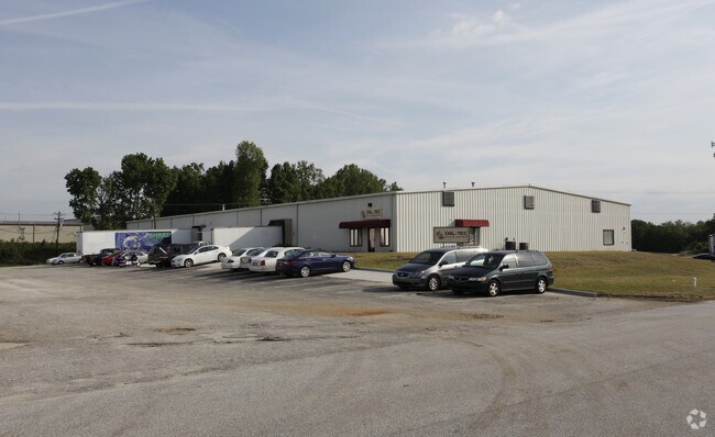
Property Detail
4020 Pelham Ct
Greenville-Anderson-Greer, SC
MAP 0530.04
0530.04-01-004.11
Greenville
Warehouse
South Carolina
I1
004.11
B and X Area of moderate flood hazard, usually the area between the limits of the 100-year and 500-year floods.
1.70 AC
2025
I-385/Woodrf Rd/Hy 14
2025
Greenville/Spartanburg
002820
NEARBY LISTINGS FOR SALE OR LEASE
DEMOGRAPHICS near 4020 Pelham Ct
1 mile
3 mile
5 mile
2025 Total Population
2,744
35,427
116,544
2030 Population
2,953
38,241
125,493
Pop Growth 2025-2030
+ 7.62%
+ 7.94%
+ 7.68%
Average Age
40
41
40
2025 Total Households
916
13,616
44,831
HH Growth 2025-2030
+ 7.97%
+ 8.10%
+ 7.88%
Median Household Inc
$152,419
$118,047
$105,067
Avg Household Size
2.90
2.60
2.60
2025 Avg HH Vehicles
2.00
2.00
2.00
Median Home Value
$442,968
$471,154
$397,209
Median Year Built
1996
1999
1998
Nearby Places
Map Layers
Map Styles
 Street
 Aerial
Layers
 Traffic
 Biking
Places
Listings with unknown addresses are not visible on the map
- Restaurants
- Banks
- Shops
- Fitness
- Groceries
PUBLIC TRANSPORTATION
AIRPORT
Greenville Spartanburg International
Drive
Walk
Distance
Greenville Spartanburg International
8 min
4.2 mi
Nearby Properties
Address
Land Use
TOTAL SIZE
Lot Size
Zoning
Address
Land Use
TOTAL SIZE
Lot Size
Zoning
136.04 AC
I1
Address
Land Use
TOTAL SIZE
Lot Size
Zoning
18.55 AC
RS
Address
Land Use
TOTAL SIZE
Lot Size
Zoning
88.98 AC
RS
Address
Land Use
TOTAL SIZE
Lot Size
Zoning
2,355 SF
10.21 AC
RS
Address
Land Use
TOTAL SIZE
Lot Size
Zoning
20.40 AC
RS
Address
Land Use
TOTAL SIZE
Lot Size
Zoning
18.50 AC
PD
Address
Land Use
TOTAL SIZE
Lot Size
Zoning
17.53 AC
I1
Address
Land Use
TOTAL SIZE
Lot Size
Zoning
1,202 SF
14.38 AC
RS
Address
Land Use
TOTAL SIZE
Lot Size
Zoning
38.86 AC
C2
Address
Land Use
TOTAL SIZE
Lot Size
Zoning
12.20 AC
PDC
Address
Land Use
TOTAL SIZE
Lot Size
Zoning
0.66 AC
PD
Address
Land Use
TOTAL SIZE
Lot Size
Zoning
5.47 AC
C3
Address
Land Use
TOTAL SIZE
Lot Size
Zoning
143.57 AC
I1
Address
Land Use
TOTAL SIZE
Lot Size
Zoning
91.80 AC
PD
Address
Land Use
TOTAL SIZE
Lot Size
Zoning
86,884 SF
5.31 AC
Address
Land Use
TOTAL SIZE
Lot Size
Zoning
5.70 AC
I1
Address
Land Use
TOTAL SIZE
Lot Size
Zoning
9.40 AC
RM1
Address
Land Use
TOTAL SIZE
Lot Size
Zoning
9.27 AC
I1
Address
Land Use
TOTAL SIZE
Lot Size
Zoning
4.80 AC
I1
Address
Land Use
TOTAL SIZE
Lot Size
Zoning
9.90 AC
I1
Address
Land Use
TOTAL SIZE
Lot Size
Zoning
16.50 AC
TS1
Address
Land Use
TOTAL SIZE
Lot Size
Zoning
15.90 AC
TS1
Address
Land Use
TOTAL SIZE
Lot Size
Zoning
5.80 AC
RS
Address
Land Use
TOTAL SIZE
Lot Size
Zoning
4,128 SF
25.54 AC
RS
Address
Land Use
TOTAL SIZE
Lot Size
Zoning
29 AC
I1
Address
Land Use
TOTAL SIZE
Lot Size
Zoning
22.48 AC
I1
Address
Land Use
TOTAL SIZE
Lot Size
Zoning
2.30 AC
I1
Address
Land Use
TOTAL SIZE
Lot Size
Zoning
23.20 AC
PD
Address
Land Use
TOTAL SIZE
Lot Size
Zoning
2.73 AC
C3
Address
Land Use
TOTAL SIZE
Lot Size
Zoning
2 AC
PD
The World's #1 Commercial Real Estate Marketplace
Connect with us
© 2026 CoStar Group
The information above has been obtained from sources believed reliable. While we do not doubt its accuracy we have not verified it and make no guarantee, warranty or representation about it. It is your responsibility to independently confirm its accuracy and completeness. Any projections, opinions, assumptions, or estimates used are for example only and do not represent the current or future performance of the property. The value of this transaction to you depends on tax and other factors which should be evaluated by your tax, financial, and legal advisors. You and your advisors should conduct a careful, independent investigation of the property to determine to your satisfaction the suitability of the property for your needs.