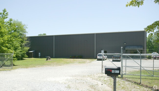
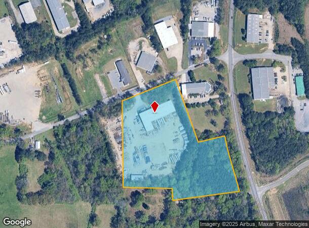
Property Record
4021 Farr Rd, Bessemer, AL 35022

NEARBY LISTINGS FOR SALE OR LEASE
Property Detail
4021 Farr Rd
38-00-22-4-001-002.009
COM NW COR OF NW 1/4 OF SE 1/4 OF SEC 22 TSP 19S R 4W TH S 685 FT TO POB CONT S 555 FT TH E 332 FT TH S 81.3 FT TH NE 451.8 FT TH NE 38.9 FT TO WLY R/W OF MORGAN RD SE TH NLY ALG R/W 341.9 FT TH SW 250 FT TH NW 412.8 FT TO S R/W OF FARR RD TH SW ALG
Commercialnec
Jefferson
X
Alabama
01073C0677H
8.65 AC
2023
Bessemer
2024
Birmingham
014301
Birmingham-Hoover, AL
19,375 SF
DEMOGRAPHICS near 4021 Farr Rd
1 Mile
3 Mile
5 Mile
2024 Total Population
1,321
22,344
65,485
2029 Population
1,304
22,063
64,291
Pop Growth 2024-2029
(1.29%)
(1.26%)
(1.82%)
Average Age
41
40
40
2024 Total Households
549
8,949
25,337
HH Growth 2024-2029
(1.64%)
(1.45%)
(1.92%)
Median Household Inc
$42,285
$41,042
$58,534
Avg Household Size
2.40
2.40
2.50
2024 Avg HH Vehicles
2.00
2.00
2.00
Median Home Value
$124,336
$148,339
$219,929
Median Year Built
1972
1966
1984
Nearby Places
Map Layers
Map Styles
 Street
 Aerial
- Restaurants
- Banks
- Shops
- Fitness
- Groceries
PUBLIC TRANSPORTATION
AIRPORT
Birmingham-Shuttlesworth International
DRIVE
WALK
Distance
Birmingham-Shuttlesworth International
32 min
23.2 mi
Nearby Properties
Address
Land Use
TOTAL SIZE
Lot Size
Zoning
Address
Land Use
TOTAL SIZE
Lot Size
Zoning
106 AC
I3
Address
Land Use
TOTAL SIZE
Lot Size
Zoning
929,435 SF
58 AC
I4
Address
Land Use
TOTAL SIZE
Lot Size
Zoning
184,428 SF
9.70 AC
01
Address
Land Use
TOTAL SIZE
Lot Size
Zoning
210,815 SF
114 AC
I1-A
Address
Land Use
TOTAL SIZE
Lot Size
Zoning
47,705 SF
0.69 AC
01
Address
Land Use
TOTAL SIZE
Lot Size
Zoning
113,220 SF
22.60 AC
I3
Address
Land Use
TOTAL SIZE
Lot Size
Zoning
187,200 SF
22 AC
I3
Address
Land Use
TOTAL SIZE
Lot Size
Zoning
440,970 SF
16 AC
I2
Address
Land Use
TOTAL SIZE
Lot Size
Zoning
208,000 SF
9.60 AC
SC-1
Address
Land Use
TOTAL SIZE
Lot Size
Zoning
195,461 SF
15.03 AC
C3-R
Address
Land Use
TOTAL SIZE
Lot Size
Zoning
130,568 SF
8.52 AC
SC-1
Address
Land Use
TOTAL SIZE
Lot Size
Zoning
122,720 SF
6.77 AC
O1-R
Address
Land Use
TOTAL SIZE
Lot Size
Zoning
132,116 SF
9.15 AC
R3
Address
Land Use
TOTAL SIZE
Lot Size
Zoning
123,814 SF
10.15 AC
I2
Address
Land Use
TOTAL SIZE
Lot Size
Zoning
72,745 SF
8.90 AC
SC-1
Address
Land Use
TOTAL SIZE
Lot Size
Zoning
1,090,237 SF
28.10 AC
I4
Address
Land Use
TOTAL SIZE
Lot Size
Zoning
66,900 SF
3.78 AC
I4
Address
Land Use
TOTAL SIZE
Lot Size
Zoning
3.29 AC
O1
Address
Land Use
TOTAL SIZE
Lot Size
Zoning
84,580 SF
4.41 AC
SC-1
Address
Land Use
TOTAL SIZE
Lot Size
Zoning
62,778 SF
7.25 AC
R2
Address
Land Use
TOTAL SIZE
Lot Size
Zoning
28,722 SF
2.90 AC
A-1
Address
Land Use
TOTAL SIZE
Lot Size
Zoning
44,006 SF
35.50 AC
I-1
Address
Land Use
TOTAL SIZE
Lot Size
Zoning
33,226 SF
7.80 AC
R4
Address
Land Use
TOTAL SIZE
Lot Size
Zoning
49,447 SF
3.89 AC
SC-1
Address
Land Use
TOTAL SIZE
Lot Size
Zoning
43,674 SF
0.44 AC
C3
Address
Land Use
TOTAL SIZE
Lot Size
Zoning
99,968 SF
15 AC
I-4
Address
Land Use
TOTAL SIZE
Lot Size
Zoning
172,253 SF
20 AC
C1
Address
Land Use
TOTAL SIZE
Lot Size
Zoning
140,075 SF
27.50 AC
C3-I
Address
Land Use
TOTAL SIZE
Lot Size
Zoning
40,098 SF
0.48 AC
C1
Address
Land Use
TOTAL SIZE
Lot Size
Zoning
249,086 SF
21 AC
I3
The World's #1 Commercial Real Estate Marketplace
Connect with us
© 2025 CoStar Group
The information above has been obtained from sources believed reliable. While we do not doubt its accuracy we have not verified it and make no guarantee, warranty or representation about it. It is your responsibility to independently confirm its accuracy and completeness. Any projections, opinions, assumptions, or estimates used are for example only and do not represent the current or future performance of the property. The value of this transaction to you depends on tax and other factors which should be evaluated by your tax, financial, and legal advisors. You and your advisors should conduct a careful, independent investigation of the property to determine to your satisfaction the suitability of the property for your needs.