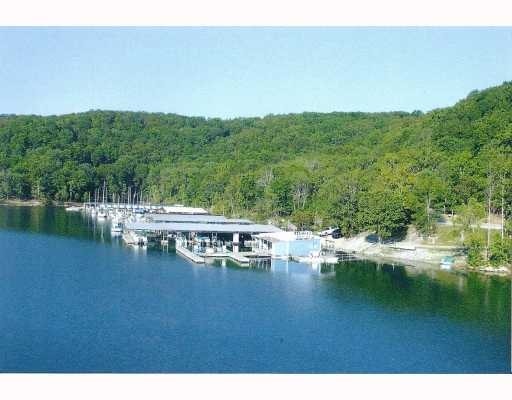
Property Record
4022 Mundell Rd, Eureka Springs, AR 72631


NEARBY LISTINGS FOR SALE OR LEASE
-
-
View all Eureka Springs listings for sale on LoopNet.com
Property Detail
4022 Mundell Rd
Storebuilding
20-20-27
X
IMPROVEMENTS ONLY
05015C0050B
Carroll
2025
Arkansas
2025
Arkansas North Area
950201
Other Market Areas
1,000 SF
001-08990-001
DEMOGRAPHICS near 4022 Mundell Rd
1 Mile
3 Mile
5 Mile
2024 Total Population
441
1,863
3,509
2029 Population
471
2,104
4,060
Pop Growth 2024-2029
+ 6.80%
+ 12.94%
+ 15.70%
Average Age
56
56
54
2024 Total Households
205
885
1,615
HH Growth 2024-2029
+ 6.83%
+ 12.99%
+ 15.54%
Median Household Inc
$52,705
$56,219
$57,612
Avg Household Size
2.00
2.00
2.10
2024 Avg HH Vehicles
2.00
2.00
2.00
Median Home Value
$271,817
$283,525
$299,812
Median Year Built
1998
1995
1994
Nearby Places
Map Layers
Map Styles
 Street
 Aerial
- Restaurants
- Banks
- Shops
- Fitness
- Groceries
PUBLIC TRANSPORTATION
AIRPORT
Northwest Arkansas Ntl
DRIVE
WALK
Distance
Northwest Arkansas Ntl
95 min
48.6 mi
Freight Ports
Tulsa Port of Inola
DRIVE
WALK
Distance
Tulsa Port of Inola
182 min
133.8 mi
Nearby Properties
Address
Land Use
TOTAL SIZE
Lot Size
Zoning
Address
Land Use
TOTAL SIZE
Lot Size
Zoning
15,867 SF
4.86 AC
Address
Land Use
TOTAL SIZE
Lot Size
Zoning
11,214 SF
6.89 AC
Address
Land Use
TOTAL SIZE
Lot Size
Zoning
10,770 SF
8.13 AC
Address
Land Use
TOTAL SIZE
Lot Size
Zoning
8,602 SF
4.33 AC
Address
Land Use
TOTAL SIZE
Lot Size
Zoning
3,712 SF
2.84 AC
Address
Land Use
TOTAL SIZE
Lot Size
Zoning
5,122 SF
2.51 AC
Address
Land Use
TOTAL SIZE
Lot Size
Zoning
6,496 SF
3.38 AC
Address
Land Use
TOTAL SIZE
Lot Size
Zoning
7.88 AC
Address
Land Use
TOTAL SIZE
Lot Size
Zoning
1,680 SF
5 AC
Address
Land Use
TOTAL SIZE
Lot Size
Zoning
9.21 AC
Address
Land Use
TOTAL SIZE
Lot Size
Zoning
2,097 SF
1.64 AC
Address
Land Use
TOTAL SIZE
Lot Size
Zoning
9.91 AC
Address
Land Use
TOTAL SIZE
Lot Size
Zoning
7.60 AC
Address
Land Use
TOTAL SIZE
Lot Size
Zoning
4,448 SF
1.07 AC
Address
Land Use
TOTAL SIZE
Lot Size
Zoning
Address
Land Use
TOTAL SIZE
Lot Size
Zoning
Address
Land Use
TOTAL SIZE
Lot Size
Zoning
Address
Land Use
TOTAL SIZE
Lot Size
Zoning
Address
Land Use
TOTAL SIZE
Lot Size
Zoning
Address
Land Use
TOTAL SIZE
Lot Size
Zoning
Address
Land Use
TOTAL SIZE
Lot Size
Zoning
Address
Land Use
TOTAL SIZE
Lot Size
Zoning
Address
Land Use
TOTAL SIZE
Lot Size
Zoning
5.79 AC
Address
Land Use
TOTAL SIZE
Lot Size
Zoning
7.23 AC
Address
Land Use
TOTAL SIZE
Lot Size
Zoning
0.64 AC
Address
Land Use
TOTAL SIZE
Lot Size
Zoning
Address
Land Use
TOTAL SIZE
Lot Size
Zoning
Address
Land Use
TOTAL SIZE
Lot Size
Zoning
Address
Land Use
TOTAL SIZE
Lot Size
Zoning
0.61 AC
The World's #1 Commercial Real Estate Marketplace
Connect with us
© 2026 CoStar Group
The information above has been obtained from sources believed reliable. While we do not doubt its accuracy we have not verified it and make no guarantee, warranty or representation about it. It is your responsibility to independently confirm its accuracy and completeness. Any projections, opinions, assumptions, or estimates used are for example only and do not represent the current or future performance of the property. The value of this transaction to you depends on tax and other factors which should be evaluated by your tax, financial, and legal advisors. You and your advisors should conduct a careful, independent investigation of the property to determine to your satisfaction the suitability of the property for your needs.