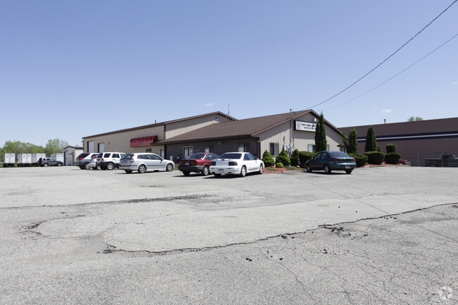
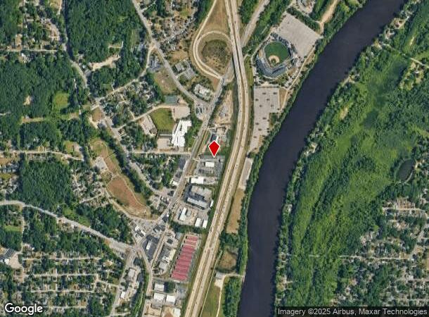
Property Record
4022 W River Dr Ne, Comstock Park, MI 49321

NEARBY LISTINGS FOR SALE OR LEASE
-
-
-
No Photo
-
-
View all Comstock Park listings for lease on LoopNet.com
Property Detail
4022 W River Dr Ne
41-10-30-401-030
PART SE 1/4 COM ON CL OF W RIVER RD 832.4 FT S 64D 51M E FROM A PT ON N&S 1/4 LINE 1773.42 FT N OF S 1/4 COR TH S 27D 29M W
Industrialgeneral
Kent
AE
Michigan
26081C0291D
1.55 AC
0
Comstock/Alpine
2025
West Michigan
011101
Grand Rapids-Wyoming, MI
DEMOGRAPHICS near 4022 W River Dr Ne
1 Mile
3 Mile
5 Mile
2024 Total Population
5,123
47,664
133,013
2029 Population
5,142
47,922
133,520
Pop Growth 2024-2029
+ 0.37%
+ 0.54%
+ 0.38%
Average Age
39
39
38
2024 Total Households
2,153
20,059
55,992
HH Growth 2024-2029
+ 0.37%
+ 0.55%
+ 0.42%
Median Household Inc
$61,119
$67,159
$66,219
Avg Household Size
2.30
2.30
2.30
2024 Avg HH Vehicles
2.00
2.00
2.00
Median Home Value
$221,280
$221,819
$230,428
Median Year Built
1981
1969
1966
Nearby Places
Map Layers
Map Styles
 Street
 Aerial
- Restaurants
- Banks
- Shops
- Fitness
- Groceries
PUBLIC TRANSPORTATION
COMMUTER RAIL
Grand Rapids Vernon J. Ehlers Station (Pere Marquette - Amtrak)
DRIVE
WALK
Distance
Grand Rapids Vernon J. Ehlers Station (Pere Marquette - Amtrak)
9 min
6.9 mi
AIRPORT
Gerald R Ford International
DRIVE
WALK
Distance
Gerald R Ford International
27 min
19.2 mi
Freight Ports
Port Milwaukee
DRIVE
WALK
Distance
Port Milwaukee
311 min
268.1 mi
SALE & LEASE HISTORY
LISTING DATE
SALE/LEASE

Oct 05, 2023
For Lease
Oct 05, 2023
For Sale
Nearby Properties
Address
Land Use
TOTAL SIZE
Lot Size
Zoning
Address
Land Use
TOTAL SIZE
Lot Size
Zoning
537,080 SF
46.61 AC
RPUD - 2
Address
Land Use
TOTAL SIZE
Lot Size
Zoning
451,792 SF
32.60 AC
ARM - MULT
Address
Land Use
TOTAL SIZE
Lot Size
Zoning
21.77 AC
MCN-MDR
Address
Land Use
TOTAL SIZE
Lot Size
Zoning
Address
Land Use
TOTAL SIZE
Lot Size
Zoning
Address
Land Use
TOTAL SIZE
Lot Size
Zoning
33.06 AC
R-3
Address
Land Use
TOTAL SIZE
Lot Size
Zoning
158,449 SF
14.33 AC
MCN-MDR
Address
Land Use
TOTAL SIZE
Lot Size
Zoning
Address
Land Use
TOTAL SIZE
Lot Size
Zoning
136,468 SF
13.34 AC
CPUD
Address
Land Use
TOTAL SIZE
Lot Size
Zoning
165,184 SF
14.85 AC
CPUD
Address
Land Use
TOTAL SIZE
Lot Size
Zoning
32.63 AC
R-3
Address
Land Use
TOTAL SIZE
Lot Size
Zoning
214,046 SF
31.31 AC
C-2
Address
Land Use
TOTAL SIZE
Lot Size
Zoning
118,085 SF
10.94 AC
CPUD
Address
Land Use
TOTAL SIZE
Lot Size
Zoning
13.26 AC
MON-MDR
Address
Land Use
TOTAL SIZE
Lot Size
Zoning
Address
Land Use
TOTAL SIZE
Lot Size
Zoning
169,926 SF
8.52 AC
C-2
Address
Land Use
TOTAL SIZE
Lot Size
Zoning
Address
Land Use
TOTAL SIZE
Lot Size
Zoning
239,172 SF
25.79 AC
C-2
Address
Land Use
TOTAL SIZE
Lot Size
Zoning
9.11 AC
R-3
Address
Land Use
TOTAL SIZE
Lot Size
Zoning
8.77 AC
R-3
Address
Land Use
TOTAL SIZE
Lot Size
Zoning
14.36 AC
MON-MDR
Address
Land Use
TOTAL SIZE
Lot Size
Zoning
221,081 SF
22.91 AC
C-2
Address
Land Use
TOTAL SIZE
Lot Size
Zoning
11.86 AC
R-3
Address
Land Use
TOTAL SIZE
Lot Size
Zoning
97,894 SF
5.90 AC
MCN-LDR
Address
Land Use
TOTAL SIZE
Lot Size
Zoning
91,434 SF
14.22 AC
CPUD
Address
Land Use
TOTAL SIZE
Lot Size
Zoning
209,404 SF
13.20 AC
MH
Address
Land Use
TOTAL SIZE
Lot Size
Zoning
54,177 SF
1.54 AC
CPUD
Address
Land Use
TOTAL SIZE
Lot Size
Zoning
94,920 SF
3.46 AC
CPUD
Address
Land Use
TOTAL SIZE
Lot Size
Zoning
Address
Land Use
TOTAL SIZE
Lot Size
Zoning
10.48 AC
R-3
The World's #1 Commercial Real Estate Marketplace
Connect with us
© 2025 CoStar Group
The information above has been obtained from sources believed reliable. While we do not doubt its accuracy we have not verified it and make no guarantee, warranty or representation about it. It is your responsibility to independently confirm its accuracy and completeness. Any projections, opinions, assumptions, or estimates used are for example only and do not represent the current or future performance of the property. The value of this transaction to you depends on tax and other factors which should be evaluated by your tax, financial, and legal advisors. You and your advisors should conduct a careful, independent investigation of the property to determine to your satisfaction the suitability of the property for your needs.