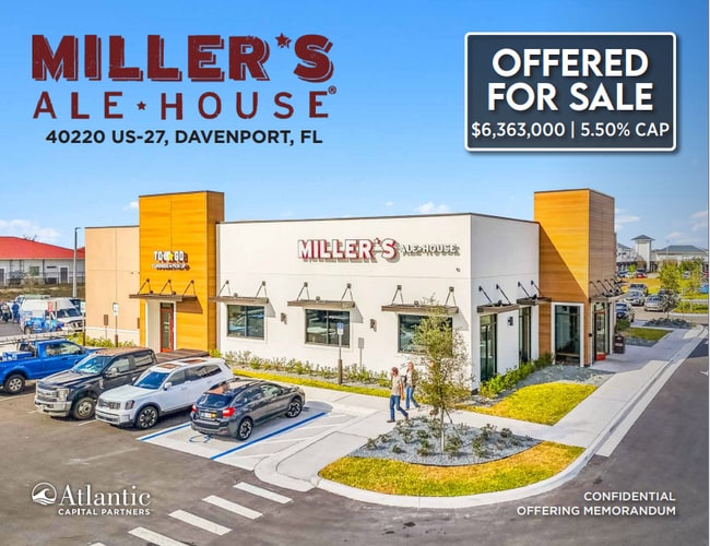
Property Record
40220 Highway 27, Davenport, FL 33837


NEARBY LISTINGS FOR SALE OR LEASE
Property Detail
40220 Highway 27
Tampa/St Petersburg
Wmg Park Place
Lakeland-Winter Haven, FL
WMG PARK PLACE PB 210 PGS 14-15 LOT B
27-26-31-709008-000020
Polk
Restaurantbuilding
Florida
0
b
2025
2.03 AC
012514
Polk County
7,150 SF
DEMOGRAPHICS near 40220 Highway 27
1 Mile
3 Mile
5 Mile
2024 Total Population
7,400
41,902
88,087
2029 Population
9,369
52,512
110,199
Pop Growth 2024-2029
+ 26.61%
+ 25.32%
+ 25.10%
Average Age
40
41
40
2024 Total Households
2,589
15,127
31,390
HH Growth 2024-2029
+ 26.57%
+ 25.22%
+ 25.14%
Median Household Inc
$67,668
$65,926
$62,574
Avg Household Size
2.90
2.70
2.80
2024 Avg HH Vehicles
2.00
2.00
2.00
Median Home Value
$260,319
$247,588
$244,201
Median Year Built
2010
2010
2010
Nearby Places
Map Layers
Map Styles
 Street
 Aerial
- Restaurants
- Banks
- Shops
- Fitness
- Groceries
PUBLIC TRANSPORTATION
AIRPORT
Orlando International
DRIVE
WALK
Distance
Orlando International
43 min
32.8 mi
Freight Ports
Port of Tampa Bay
DRIVE
WALK
Distance
Port of Tampa Bay
73 min
61.0 mi
SALE & LEASE HISTORY
LISTING DATE
SALE/LEASE

Jan 07, 2025
For Sale
Nearby Properties
Address
Land Use
TOTAL SIZE
Lot Size
Zoning
Address
Land Use
TOTAL SIZE
Lot Size
Zoning
306,788 SF
13.35 AC
XX
Address
Land Use
TOTAL SIZE
Lot Size
Zoning
310,669 SF
36.01 AC
RC
Address
Land Use
TOTAL SIZE
Lot Size
Zoning
328,817 SF
12.62 AC
Address
Land Use
TOTAL SIZE
Lot Size
Zoning
491,027 SF
18.81 AC
RC
Address
Land Use
TOTAL SIZE
Lot Size
Zoning
394,505 SF
25.69 AC
Address
Land Use
TOTAL SIZE
Lot Size
Zoning
132,578 SF
0.31 AC
Address
Land Use
TOTAL SIZE
Lot Size
Zoning
60,240 SF
9.21 AC
RC
Address
Land Use
TOTAL SIZE
Lot Size
Zoning
41,438 SF
7.92 AC
Address
Land Use
TOTAL SIZE
Lot Size
Zoning
46,800 SF
3.28 AC
Address
Land Use
TOTAL SIZE
Lot Size
Zoning
146,350 SF
19.49 AC
Address
Land Use
TOTAL SIZE
Lot Size
Zoning
65,340 SF
18.65 AC
RC
Address
Land Use
TOTAL SIZE
Lot Size
Zoning
23,385 SF
8.84 AC
RC
Address
Land Use
TOTAL SIZE
Lot Size
Zoning
28,836 SF
2.02 AC
Address
Land Use
TOTAL SIZE
Lot Size
Zoning
128,885 SF
8.39 AC
Address
Land Use
TOTAL SIZE
Lot Size
Zoning
115,039 SF
7.46 AC
RC
Address
Land Use
TOTAL SIZE
Lot Size
Zoning
84,480 SF
4.68 AC
RC
Address
Land Use
TOTAL SIZE
Lot Size
Zoning
27,530 SF
4.60 AC
Address
Land Use
TOTAL SIZE
Lot Size
Zoning
10,656 SF
3.49 AC
Address
Land Use
TOTAL SIZE
Lot Size
Zoning
30,472 SF
9.49 AC
Address
Land Use
TOTAL SIZE
Lot Size
Zoning
29,536 SF
2.51 AC
Address
Land Use
TOTAL SIZE
Lot Size
Zoning
14,684 SF
2.26 AC
Address
Land Use
TOTAL SIZE
Lot Size
Zoning
22,896 SF
0.65 AC
Address
Land Use
TOTAL SIZE
Lot Size
Zoning
22,896 SF
0.56 AC
Address
Land Use
TOTAL SIZE
Lot Size
Zoning
21,199 SF
2.16 AC
Address
Land Use
TOTAL SIZE
Lot Size
Zoning
18,018 SF
1.94 AC
Address
Land Use
TOTAL SIZE
Lot Size
Zoning
16,186 SF
2.41 AC
Address
Land Use
TOTAL SIZE
Lot Size
Zoning
14,849 SF
1.90 AC
Address
Land Use
TOTAL SIZE
Lot Size
Zoning
67.70 AC
RC
Address
Land Use
TOTAL SIZE
Lot Size
Zoning
13,452 SF
1.75 AC
Address
Land Use
TOTAL SIZE
Lot Size
Zoning
8.45 AC
C3
The World's #1 Commercial Real Estate Marketplace
Connect with us
© 2026 CoStar Group
The information above has been obtained from sources believed reliable. While we do not doubt its accuracy we have not verified it and make no guarantee, warranty or representation about it. It is your responsibility to independently confirm its accuracy and completeness. Any projections, opinions, assumptions, or estimates used are for example only and do not represent the current or future performance of the property. The value of this transaction to you depends on tax and other factors which should be evaluated by your tax, financial, and legal advisors. You and your advisors should conduct a careful, independent investigation of the property to determine to your satisfaction the suitability of the property for your needs.