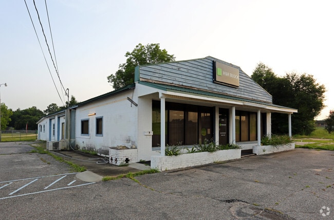
Property Record
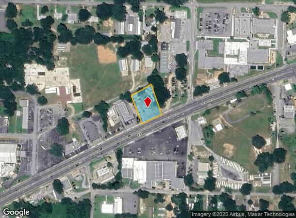
4024 Highway 90, Pace, FL 32571

NEARBY LISTINGS FOR SALE OR LEASE
Property Detail
4024 Highway 90
16-1N-29-0000-01300-0000
**DESCRIPTION UPDATE FOR 2024** COM AT SW COR OF N2 OF GOV LT 2 16-1N-29W TH N 00*3713 W 292.11 FT TO NLY R/W OF HWY 90 TH N 60*5951E 139 FT TO POINT ON CURVE TH CONT NELY ALONG CURVE (R= 8644.42 FT CA 01*3153 CHB 61*4547E) 231.06 FT TO POB TH N 23*5
Officebuilding
Santa Rosa
VE
Florida
12113C0420H
2
2024
0.79 AC
2025
Avalon Beach/Milton
010301
Pensacola
4,443 SF
Pensacola-Ferry Pass-Brent, FL
DEMOGRAPHICS near 4024 Highway 90
1 mile
3 mile
5 mile
2024 Total Population
5,547
26,668
49,350
2029 Population
6,333
30,607
56,469
Pop Growth 2024-2029
+ 14.17%
+ 14.77%
+ 14.43%
Average Age
38
39
39
2024 Total Households
2,078
9,743
18,109
HH Growth 2024-2029
+ 14.49%
+ 15.06%
+ 14.69%
Median Household Inc
$68,575
$71,501
$82,541
Avg Household Size
2.60
2.70
2.70
2024 Avg HH Vehicles
2.00
2.00
2.00
Median Home Value
$191,625
$244,708
$255,029
Median Year Built
1989
1996
1997
Nearby Places
Map Layers
Map Styles
 Street
 Aerial
Transit
 Traffic
 Biking
Places
Listings with unknown addresses are not visible on the map
- Restaurants
- Banks
- Shops
- Fitness
- Groceries
PUBLIC TRANSPORTATION
AIRPORT
Pensacola International
Drive
Walk
Distance
Pensacola International
24 min
12.7 mi
SALE & LEASE HISTORY
LISTING DATE
SALE/LEASE

Nov 03, 2023
For Sale
Nearby Properties
Address
Land Use
TOTAL SIZE
Lot Size
Zoning
Address
Land Use
TOTAL SIZE
Lot Size
Zoning
374,114 SF
27.61 AC
R2
Address
Land Use
TOTAL SIZE
Lot Size
Zoning
130,379 SF
18.18 AC
HCD
Address
Land Use
TOTAL SIZE
Lot Size
Zoning
79,708 SF
9.62 AC
HCD
Address
Land Use
TOTAL SIZE
Lot Size
Zoning
232,988 SF
24.57 AC
HCD
Address
Land Use
TOTAL SIZE
Lot Size
Zoning
154,042 SF
10.36 AC
HCD
Address
Land Use
TOTAL SIZE
Lot Size
Zoning
130,603 SF
14.30 AC
R2
Address
Land Use
TOTAL SIZE
Lot Size
Zoning
47.05 AC
AG-RR
Address
Land Use
TOTAL SIZE
Lot Size
Zoning
151,084 SF
19.01 AC
HCD
Address
Land Use
TOTAL SIZE
Lot Size
Zoning
78,019 SF
7 AC
R3
Address
Land Use
TOTAL SIZE
Lot Size
Zoning
199,775 SF
8.83 AC
HCD
Address
Land Use
TOTAL SIZE
Lot Size
Zoning
113,899 SF
3.05 AC
HCD
Address
Land Use
TOTAL SIZE
Lot Size
Zoning
81,123 SF
8.78 AC
HCD
Address
Land Use
TOTAL SIZE
Lot Size
Zoning
60,129 SF
0.11 AC
HCD
Address
Land Use
TOTAL SIZE
Lot Size
Zoning
23.33 AC
AG-RR
Address
Land Use
TOTAL SIZE
Lot Size
Zoning
13.70 AC
HCD
Address
Land Use
TOTAL SIZE
Lot Size
Zoning
76,674 SF
2.80 AC
HCD
Address
Land Use
TOTAL SIZE
Lot Size
Zoning
93,476 SF
7.43 AC
HCD
Address
Land Use
TOTAL SIZE
Lot Size
Zoning
43,613 SF
3.44 AC
HCD
Address
Land Use
TOTAL SIZE
Lot Size
Zoning
389.54 AC
AG-RR
Address
Land Use
TOTAL SIZE
Lot Size
Zoning
9.61 AC
R1
Address
Land Use
TOTAL SIZE
Lot Size
Zoning
112,196 SF
343.01 AC
HCD
Address
Land Use
TOTAL SIZE
Lot Size
Zoning
50,616 SF
2.56 AC
R3
Address
Land Use
TOTAL SIZE
Lot Size
Zoning
30,564 SF
11.12 AC
HCD
Address
Land Use
TOTAL SIZE
Lot Size
Zoning
23,668 SF
2.30 AC
HCD
Address
Land Use
TOTAL SIZE
Lot Size
Zoning
49,275 SF
2.49 AC
HCD
Address
Land Use
TOTAL SIZE
Lot Size
Zoning
13,560 SF
5.93 AC
HCD
Address
Land Use
TOTAL SIZE
Lot Size
Zoning
45,485 SF
6.49 AC
HCD
Address
Land Use
TOTAL SIZE
Lot Size
Zoning
48,285 SF
3.52 AC
HCD
Address
Land Use
TOTAL SIZE
Lot Size
Zoning
62,174 SF
4 AC
HCD
The World's #1 Commercial Real Estate Marketplace
Connect with us
© 2026 CoStar Group
The information above has been obtained from sources believed reliable. While we do not doubt its accuracy we have not verified it and make no guarantee, warranty or representation about it. It is your responsibility to independently confirm its accuracy and completeness. Any projections, opinions, assumptions, or estimates used are for example only and do not represent the current or future performance of the property. The value of this transaction to you depends on tax and other factors which should be evaluated by your tax, financial, and legal advisors. You and your advisors should conduct a careful, independent investigation of the property to determine to your satisfaction the suitability of the property for your needs.