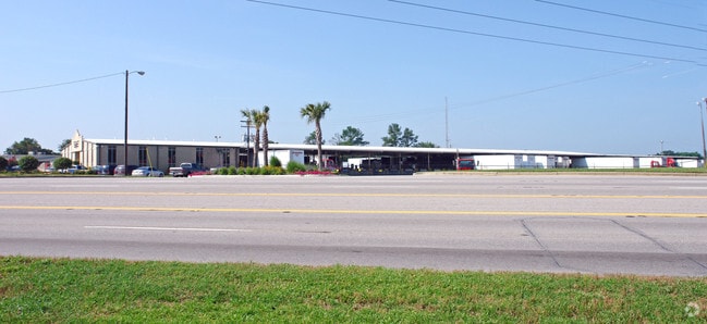
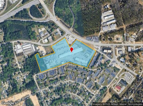
Property Record
4025 Sunset Blvd, Lexington, SC 29073

NEARBY LISTINGS FOR SALE OR LEASE
Property Detail
4025 Sunset Blvd
004596-04-038
NONE AC CHANGE - 92 HWY ROW
Publicstorage
Lexington
X
South Carolina
45063C0144J
20.45 AC
2025
Cayce/West Columbia
2024
Columbia
021051
Columbia, SC
6,916 SF
DEMOGRAPHICS near 4025 Sunset Blvd
1 mile
3 mile
5 mile
2024 Total Population
3,682
38,251
126,061
2029 Population
3,998
41,550
134,779
Pop Growth 2024-2029
+ 8.58%
+ 8.62%
+ 6.92%
Average Age
39
40
40
2024 Total Households
1,527
15,753
52,941
HH Growth 2024-2029
+ 8.78%
+ 8.81%
+ 7.12%
Median Household Inc
$70,681
$65,439
$57,868
Avg Household Size
2.40
2.40
2.20
2024 Avg HH Vehicles
2.00
2.00
2.00
Median Home Value
$176,788
$184,351
$170,374
Median Year Built
1990
1985
1982
Nearby Places
Map Layers
Map Styles
 Street
 Aerial
Transit
 Traffic
 Biking
Places
Listings with unknown addresses are not visible on the map
- Restaurants
- Banks
- Shops
- Fitness
- Groceries
PUBLIC TRANSPORTATION
COMMUTER RAIL
Drive
Walk
Distance
15 min
6.7 mi
AIRPORT
Columbia Metro
Drive
Walk
Distance
Columbia Metro
23 min
10.0 mi
Nearby Properties
Address
Land Use
TOTAL SIZE
Lot Size
Zoning
Address
Land Use
TOTAL SIZE
Lot Size
Zoning
208,016 SF
14.28 AC
GC
Address
Land Use
TOTAL SIZE
Lot Size
Zoning
58,664 SF
6.01 AC
Address
Land Use
TOTAL SIZE
Lot Size
Zoning
31,892 SF
2.23 AC
GC
Address
Land Use
TOTAL SIZE
Lot Size
Zoning
21,475 SF
4.97 AC
GC
Address
Land Use
TOTAL SIZE
Lot Size
Zoning
60,085 SF
2.35 AC
GC
Address
Land Use
TOTAL SIZE
Lot Size
Zoning
34,841 SF
2.01 AC
GC
Address
Land Use
TOTAL SIZE
Lot Size
Zoning
8,330 SF
19.10 AC
ID
Address
Land Use
TOTAL SIZE
Lot Size
Zoning
3,080 SF
18.07 AC
R
Address
Land Use
TOTAL SIZE
Lot Size
Zoning
183,776 SF
18.23 AC
C2
Address
Land Use
TOTAL SIZE
Lot Size
Zoning
3,447 SF
10.03 AC
R3
Address
Land Use
TOTAL SIZE
Lot Size
Zoning
6,794 SF
6.17 AC
R1
Address
Land Use
TOTAL SIZE
Lot Size
Zoning
190,570 SF
10.01 AC
C2
Address
Land Use
TOTAL SIZE
Lot Size
Zoning
3,824 SF
29.99 AC
R3
Address
Land Use
TOTAL SIZE
Lot Size
Zoning
9,268 SF
15.89 AC
C2
Address
Land Use
TOTAL SIZE
Lot Size
Zoning
99,628 SF
13.09 AC
RD
Address
Land Use
TOTAL SIZE
Lot Size
Zoning
14,309 SF
1.84 AC
GC
Address
Land Use
TOTAL SIZE
Lot Size
Zoning
153,351 SF
13.33 AC
RD
Address
Land Use
TOTAL SIZE
Lot Size
Zoning
85,600 SF
22.08 AC
Address
Land Use
TOTAL SIZE
Lot Size
Zoning
7,383 SF
4.85 AC
ID
Address
Land Use
TOTAL SIZE
Lot Size
Zoning
146,960 SF
9.70 AC
C2
Address
Land Use
TOTAL SIZE
Lot Size
Zoning
34,267 SF
7.53 AC
ID
Address
Land Use
TOTAL SIZE
Lot Size
Zoning
126,000 SF
8.89 AC
Address
Land Use
TOTAL SIZE
Lot Size
Zoning
8,876 SF
15.06 AC
R3
Address
Land Use
TOTAL SIZE
Lot Size
Zoning
10,616 SF
9.63 AC
R3
Address
Land Use
TOTAL SIZE
Lot Size
Zoning
3,825 SF
18.45 AC
RD
Address
Land Use
TOTAL SIZE
Lot Size
Zoning
127,329 SF
10.91 AC
Address
Land Use
TOTAL SIZE
Lot Size
Zoning
79,951 SF
3.31 AC
RD
Address
Land Use
TOTAL SIZE
Lot Size
Zoning
39,700 SF
73.29 AC
ID
Address
Land Use
TOTAL SIZE
Lot Size
Zoning
48,751 SF
4.30 AC
ID
Address
Land Use
TOTAL SIZE
Lot Size
Zoning
66,043 SF
2.70 AC
ID
The World's #1 Commercial Real Estate Marketplace
Connect with us
© 2026 CoStar Group
The information above has been obtained from sources believed reliable. While we do not doubt its accuracy we have not verified it and make no guarantee, warranty or representation about it. It is your responsibility to independently confirm its accuracy and completeness. Any projections, opinions, assumptions, or estimates used are for example only and do not represent the current or future performance of the property. The value of this transaction to you depends on tax and other factors which should be evaluated by your tax, financial, and legal advisors. You and your advisors should conduct a careful, independent investigation of the property to determine to your satisfaction the suitability of the property for your needs.