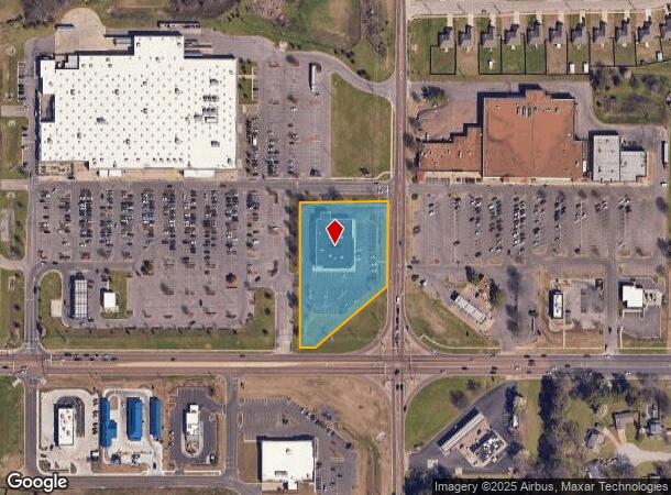
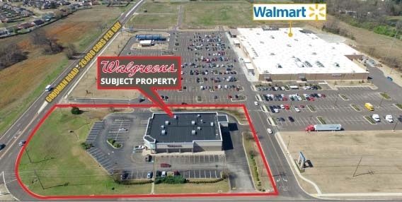
Property Record
4028 Goodman Rd W, Horn Lake, MS 38637

NEARBY LISTINGS FOR SALE OR LEASE
Property Detail
4028 Goodman Rd W
Memphis, TN-MS-AR
Goodman/Horn Lake S-D
1089290600000200
GOODMAN/HORN LAKE S-D LOT 2
Drugstorepharmacycvswalgreens
DeSoto
X
Mississippi
47157C0560F
2
2025
2.03 AC
2025
Southaven-Horn Lake
070210
Memphis
14,922 SF
DEMOGRAPHICS near 4028 Goodman Rd W
1 Mile
3 Mile
5 Mile
2024 Total Population
9,903
38,416
97,335
2029 Population
10,716
41,542
102,884
Pop Growth 2024-2029
+ 8.21%
+ 8.14%
+ 5.70%
Average Age
35
36
38
2024 Total Households
3,479
14,035
36,892
HH Growth 2024-2029
+ 8.28%
+ 8.23%
+ 5.86%
Median Household Inc
$45,685
$50,651
$48,090
Avg Household Size
2.80
2.70
2.60
2024 Avg HH Vehicles
2.00
2.00
2.00
Median Home Value
$135,328
$138,974
$131,005
Median Year Built
1994
1989
1982
Nearby Places
Map Layers
Map Styles
 Street
 Aerial
- Restaurants
- Banks
- Shops
- Fitness
- Groceries
PUBLIC TRANSPORTATION
AIRPORT
Memphis International
DRIVE
WALK
Distance
Memphis International
17 min
11.8 mi
Freight Ports
Port of Shreveport
DRIVE
WALK
Distance
Port of Shreveport
416 min
379.7 mi
SALE & LEASE HISTORY
LISTING DATE
SALE/LEASE

Mar 16, 2017
For Sale
Apr 12, 2018
For Sale
Nearby Properties
Address
Land Use
TOTAL SIZE
Lot Size
Zoning
Address
Land Use
TOTAL SIZE
Lot Size
Zoning
1,009,363 SF
78.56 AC
EMP
Address
Land Use
TOTAL SIZE
Lot Size
Zoning
1,021,440 SF
57.67 AC
M-1
Address
Land Use
TOTAL SIZE
Lot Size
Zoning
810,225 SF
47.71 AC
M-1
Address
Land Use
TOTAL SIZE
Lot Size
Zoning
408,580 SF
31.28 AC
M-1
Address
Land Use
TOTAL SIZE
Lot Size
Zoning
11,937 SF
18.14 AC
PUD
Address
Land Use
TOTAL SIZE
Lot Size
Zoning
186,757 SF
29 AC
C-4
Address
Land Use
TOTAL SIZE
Lot Size
Zoning
9,684 SF
13.06 AC
R-6
Address
Land Use
TOTAL SIZE
Lot Size
Zoning
499,200 SF
24.82 AC
M-1
Address
Land Use
TOTAL SIZE
Lot Size
Zoning
150,694 SF
29 AC
M-1
Address
Land Use
TOTAL SIZE
Lot Size
Zoning
10,160 SF
10 AC
RM-6
Address
Land Use
TOTAL SIZE
Lot Size
Zoning
3,773 SF
15.21 AC
PUD
Address
Land Use
TOTAL SIZE
Lot Size
Zoning
3,773 SF
14.15 AC
PUD
Address
Land Use
TOTAL SIZE
Lot Size
Zoning
84,375 SF
30.25 AC
M-1
Address
Land Use
TOTAL SIZE
Lot Size
Zoning
15,620 SF
8.68 AC
RM-6
Address
Land Use
TOTAL SIZE
Lot Size
Zoning
19,553 SF
8.65 AC
RM-6
Address
Land Use
TOTAL SIZE
Lot Size
Zoning
9,394 SF
9.10 AC
RM-6
Address
Land Use
TOTAL SIZE
Lot Size
Zoning
79.90 AC
EMP
Address
Land Use
TOTAL SIZE
Lot Size
Zoning
8,306 SF
11.40 AC
RM-8
Address
Land Use
TOTAL SIZE
Lot Size
Zoning
27,488 SF
2.24 AC
C-4
Address
Land Use
TOTAL SIZE
Lot Size
Zoning
7,442 SF
13 AC
RM-8
Address
Land Use
TOTAL SIZE
Lot Size
Zoning
62,123 SF
8.61 AC
PUD
Address
Land Use
TOTAL SIZE
Lot Size
Zoning
368,500 SF
47.18 AC
M-1
Address
Land Use
TOTAL SIZE
Lot Size
Zoning
80,022 SF
6.78 AC
PUD
Address
Land Use
TOTAL SIZE
Lot Size
Zoning
3,773 SF
7.11 AC
PUD
Address
Land Use
TOTAL SIZE
Lot Size
Zoning
15,258 SF
1.75 AC
C-4
Address
Land Use
TOTAL SIZE
Lot Size
Zoning
66,817 SF
5.91 AC
C-4
Address
Land Use
TOTAL SIZE
Lot Size
Zoning
60,000 SF
7.69 AC
PUD
Address
Land Use
TOTAL SIZE
Lot Size
Zoning
35,551 SF
6.80 AC
C-4
Address
Land Use
TOTAL SIZE
Lot Size
Zoning
46,771 SF
7.18 AC
C-4
Address
Land Use
TOTAL SIZE
Lot Size
Zoning
35,300 SF
7.19 AC
C-4
The World's #1 Commercial Real Estate Marketplace
Connect with us
© 2025 CoStar Group
The information above has been obtained from sources believed reliable. While we do not doubt its accuracy we have not verified it and make no guarantee, warranty or representation about it. It is your responsibility to independently confirm its accuracy and completeness. Any projections, opinions, assumptions, or estimates used are for example only and do not represent the current or future performance of the property. The value of this transaction to you depends on tax and other factors which should be evaluated by your tax, financial, and legal advisors. You and your advisors should conduct a careful, independent investigation of the property to determine to your satisfaction the suitability of the property for your needs.