Property Record
40282 Highway 49, Oakhurst, CA 93644

NEARBY LISTINGS FOR SALE OR LEASE
Property Detail
40282 Highway 49
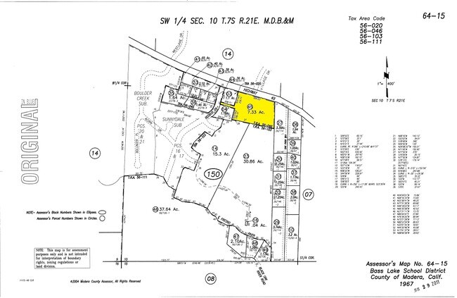
064-150-045
SEC 10 T7S R21E
Vacantlandnec
Madera
X
California
06039C0483E
7.33 AC
2024
Outlying Madera County
2025
Fresno
000103
Fresno, CA
DEMOGRAPHICS near 40282 Highway 49
1 Mile
3 Mile
5 Mile
2024 Total Population
1,426
5,754
11,163
2029 Population
1,540
6,208
12,069
Pop Growth 2024-2029
+ 7.99%
+ 7.89%
+ 8.12%
Average Age
47
47
47
2024 Total Households
635
2,421
4,637
HH Growth 2024-2029
+ 7.56%
+ 7.60%
+ 7.83%
Median Household Inc
$55,444
$62,717
$64,899
Avg Household Size
2.20
2.30
2.30
2024 Avg HH Vehicles
2.00
2.00
2.00
Median Home Value
$283,969
$352,807
$395,881
Median Year Built
1979
1979
1979
Nearby Places
Map Layers
Map Styles
 Street
 Aerial
- Restaurants
- Banks
- Shops
- Fitness
- Groceries
SALE & LEASE HISTORY
LISTING DATE
SALE/LEASE

Jan 20, 2021
For Sale
Nearby Properties
Address
Land Use
TOTAL SIZE
Lot Size
Zoning
Address
Land Use
TOTAL SIZE
Lot Size
Zoning
2.16 AC
Address
Land Use
TOTAL SIZE
Lot Size
Zoning
1.89 AC
Address
Land Use
TOTAL SIZE
Lot Size
Zoning
2.02 AC
Address
Land Use
TOTAL SIZE
Lot Size
Zoning
11,200 SF
36.59 AC
IH
Address
Land Use
TOTAL SIZE
Lot Size
Zoning
51,268 SF
1.79 AC
CUM
Address
Land Use
TOTAL SIZE
Lot Size
Zoning
47,308 SF
2.51 AC
CRM
Address
Land Use
TOTAL SIZE
Lot Size
Zoning
42,500 SF
8.02 AC
CUM
Address
Land Use
TOTAL SIZE
Lot Size
Zoning
3.45 AC
Address
Land Use
TOTAL SIZE
Lot Size
Zoning
14.32 AC
IH
Address
Land Use
TOTAL SIZE
Lot Size
Zoning
35,254 SF
3.94 AC
PCD
Address
Land Use
TOTAL SIZE
Lot Size
Zoning
12.77 AC
CUM
Address
Land Use
TOTAL SIZE
Lot Size
Zoning
8,500 SF
2.79 AC
CUM
Address
Land Use
TOTAL SIZE
Lot Size
Zoning
16,988 SF
1.93 AC
CRM
Address
Land Use
TOTAL SIZE
Lot Size
Zoning
3.84 AC
CRG
Address
Land Use
TOTAL SIZE
Lot Size
Zoning
2,448 SF
5.59 AC
RUM
Address
Land Use
TOTAL SIZE
Lot Size
Zoning
31,785 SF
4.61 AC
CRG
Address
Land Use
TOTAL SIZE
Lot Size
Zoning
7,320 SF
1.04 AC
CUM
Address
Land Use
TOTAL SIZE
Lot Size
Zoning
46,607 SF
9.04 AC
RUS
Address
Land Use
TOTAL SIZE
Lot Size
Zoning
28,176 SF
2.35 AC
RUM
Address
Land Use
TOTAL SIZE
Lot Size
Zoning
0.84 AC
PSC
Address
Land Use
TOTAL SIZE
Lot Size
Zoning
0.39 AC
CUM
Address
Land Use
TOTAL SIZE
Lot Size
Zoning
33,000 SF
6.41 AC
CUM
Address
Land Use
TOTAL SIZE
Lot Size
Zoning
6,289 SF
13.68 AC
CRM
Address
Land Use
TOTAL SIZE
Lot Size
Zoning
16,750 SF
2.92 AC
CUM
Address
Land Use
TOTAL SIZE
Lot Size
Zoning
21,000 SF
1.80 AC
RUM
Address
Land Use
TOTAL SIZE
Lot Size
Zoning
4.31 AC
RRM
Address
Land Use
TOTAL SIZE
Lot Size
Zoning
1.23 AC
CUM
Address
Land Use
TOTAL SIZE
Lot Size
Zoning
0.51 AC
CUM
Address
Land Use
TOTAL SIZE
Lot Size
Zoning
917 SF
4.81 AC
PCD
Address
Land Use
TOTAL SIZE
Lot Size
Zoning
0.52 AC
CUM
The World's #1 Commercial Real Estate Marketplace
Connect with us
© 2026 CoStar Group
The information above has been obtained from sources believed reliable. While we do not doubt its accuracy we have not verified it and make no guarantee, warranty or representation about it. It is your responsibility to independently confirm its accuracy and completeness. Any projections, opinions, assumptions, or estimates used are for example only and do not represent the current or future performance of the property. The value of this transaction to you depends on tax and other factors which should be evaluated by your tax, financial, and legal advisors. You and your advisors should conduct a careful, independent investigation of the property to determine to your satisfaction the suitability of the property for your needs.