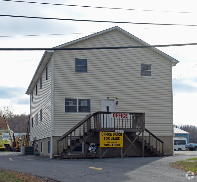
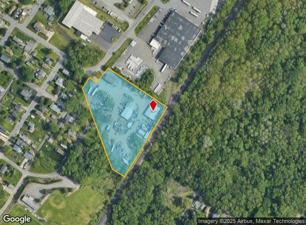
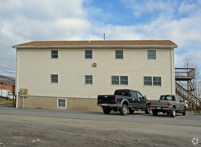
Property Record
N South Rd At Briggs St, Scranton, PA 18504
NEARBY LISTINGS FOR SALE OR LEASE
Property Detail
N South Rd At Briggs St
1441205002701
3.795A BLDG & LAND W-21 B- L- P-
Taxexempt
Lackawanna
AE
Pennsylvania
42069C0212D
3.80 AC
2025
I-81 Corridor
2025
Philadelphia
102000
Scranton--Wilkes-Barre--Hazelton, PA
DEMOGRAPHICS near N South Rd At Briggs St
1 Mile
3 Mile
5 Mile
2024 Total Population
10,522
77,888
125,116
2029 Population
10,357
77,423
123,973
Pop Growth 2024-2029
(1.57%)
(0.60%)
(0.91%)
Average Age
41
40
41
2024 Total Households
4,344
30,791
51,073
HH Growth 2024-2029
(1.57%)
(0.59%)
(0.94%)
Median Household Inc
$57,539
$47,834
$56,944
Avg Household Size
2.30
2.30
2.20
2024 Avg HH Vehicles
2.00
1.00
2.00
Median Home Value
$129,733
$130,237
$154,485
Median Year Built
1946
1947
1949
Nearby Places
Map Layers
Map Styles
 Street
 Aerial
- Restaurants
- Banks
- Shops
- Fitness
- Groceries
PUBLIC TRANSPORTATION
AIRPORT
Wilkes-Barre/Scranton International
DRIVE
WALK
Distance
Wilkes-Barre/Scranton International
20 min
11.0 mi
Freight Ports
Maher Terminal
DRIVE
WALK
Distance
Maher Terminal
150 min
118.7 mi
SALE & LEASE HISTORY
LISTING DATE
SALE/LEASE

Feb 28, 2017
For Lease
Nearby Properties
Address
Land Use
TOTAL SIZE
Lot Size
Zoning
Address
Land Use
TOTAL SIZE
Lot Size
Zoning
2.62 AC
Address
Land Use
TOTAL SIZE
Lot Size
Zoning
Address
Land Use
TOTAL SIZE
Lot Size
Zoning
Address
Land Use
TOTAL SIZE
Lot Size
Zoning
Address
Land Use
TOTAL SIZE
Lot Size
Zoning
2.40 AC
Address
Land Use
TOTAL SIZE
Lot Size
Zoning
2.30 AC
Address
Land Use
TOTAL SIZE
Lot Size
Zoning
4.20 AC
Address
Land Use
TOTAL SIZE
Lot Size
Zoning
15.50 AC
Address
Land Use
TOTAL SIZE
Lot Size
Zoning
3.86 AC
Address
Land Use
TOTAL SIZE
Lot Size
Zoning
0.99 AC
Address
Land Use
TOTAL SIZE
Lot Size
Zoning
12.88 AC
Address
Land Use
TOTAL SIZE
Lot Size
Zoning
Address
Land Use
TOTAL SIZE
Lot Size
Zoning
4.85 AC
Address
Land Use
TOTAL SIZE
Lot Size
Zoning
Address
Land Use
TOTAL SIZE
Lot Size
Zoning
Address
Land Use
TOTAL SIZE
Lot Size
Zoning
2.65 AC
Address
Land Use
TOTAL SIZE
Lot Size
Zoning
0.27 AC
Address
Land Use
TOTAL SIZE
Lot Size
Zoning
Address
Land Use
TOTAL SIZE
Lot Size
Zoning
Address
Land Use
TOTAL SIZE
Lot Size
Zoning
3.86 AC
Address
Land Use
TOTAL SIZE
Lot Size
Zoning
Address
Land Use
TOTAL SIZE
Lot Size
Zoning
Address
Land Use
TOTAL SIZE
Lot Size
Zoning
3.11 AC
Address
Land Use
TOTAL SIZE
Lot Size
Zoning
9.55 AC
Address
Land Use
TOTAL SIZE
Lot Size
Zoning
Address
Land Use
TOTAL SIZE
Lot Size
Zoning
Address
Land Use
TOTAL SIZE
Lot Size
Zoning
Address
Land Use
TOTAL SIZE
Lot Size
Zoning
34.57 AC
Address
Land Use
TOTAL SIZE
Lot Size
Zoning
8.25 AC
Address
Land Use
TOTAL SIZE
Lot Size
Zoning
0.42 AC
The World's #1 Commercial Real Estate Marketplace
Connect with us
© 2025 CoStar Group
The information above has been obtained from sources believed reliable. While we do not doubt its accuracy we have not verified it and make no guarantee, warranty or representation about it. It is your responsibility to independently confirm its accuracy and completeness. Any projections, opinions, assumptions, or estimates used are for example only and do not represent the current or future performance of the property. The value of this transaction to you depends on tax and other factors which should be evaluated by your tax, financial, and legal advisors. You and your advisors should conduct a careful, independent investigation of the property to determine to your satisfaction the suitability of the property for your needs.