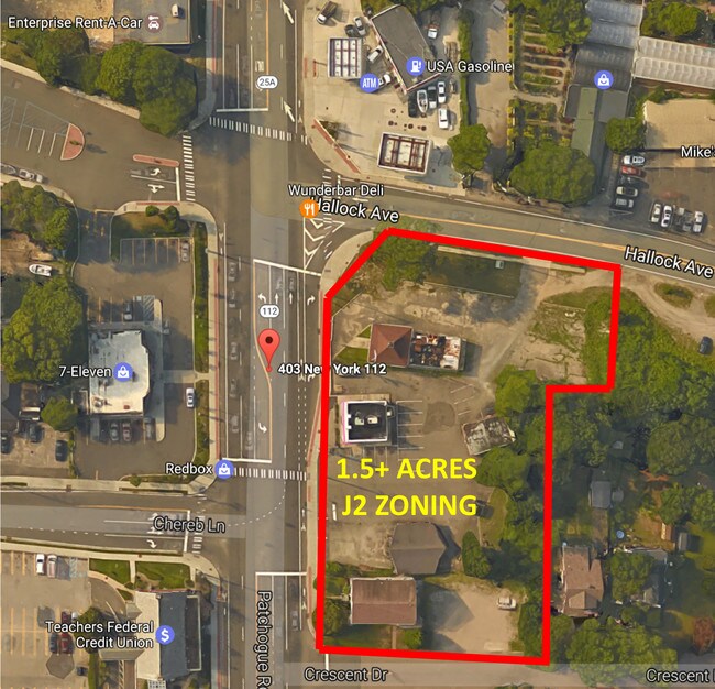
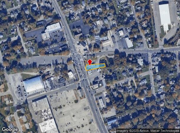
Property Record
403 Patchogue Rd, Port Jefferson Station, NY 11776
NEARBY LISTINGS FOR SALE OR LEASE
Property Detail
403 Patchogue Rd
Nassau County-Suffolk County, NY
Port Jefferson Station
0200-160-00-06-00-008-000
N RTE 25A E MP BERGEN PL & ORS S MP
Supermarket
Suffolk
X
New York
36103C0395H
8
2024
0.24 AC
2024
Central Suffolk
158209
Long Island (New York)
DEMOGRAPHICS near 403 Patchogue Rd
1 Mile
3 Mile
5 Mile
2024 Total Population
9,981
63,805
162,219
2029 Population
10,113
63,275
160,026
Pop Growth 2024-2029
+ 1.32%
(0.83%)
(1.35%)
Average Age
41
43
41
2024 Total Households
3,855
22,593
52,198
HH Growth 2024-2029
+ 1.19%
(1.03%)
(1.59%)
Median Household Inc
$106,115
$124,842
$120,387
Avg Household Size
2.40
2.70
2.80
2024 Avg HH Vehicles
2.00
2.00
2.00
Median Home Value
$478,072
$504,481
$470,563
Median Year Built
1982
1975
1973
Nearby Places
- Restaurants
- Banks
- Shops
- Fitness
- Groceries
PUBLIC TRANSPORTATION
COMMUTER RAIL
Port Jefferson Station (Port Jefferson Branch - Long Island Rail Road)
DRIVE
WALK
Distance
Port Jefferson Station (Port Jefferson Branch - Long Island Rail Road)
6 min
2.0 mi
St James Station (Port Jefferson Branch - Long Island Rail Road)
DRIVE
WALK
Distance
St James Station (Port Jefferson Branch - Long Island Rail Road)
19 min
9.6 mi
AIRPORT
Long Island MacArthur
DRIVE
WALK
Distance
Long Island MacArthur
25 min
18.5 mi
SALE & LEASE HISTORY
LISTING DATE
SALE/LEASE

Sep 22, 2017
For Sale
Jun 19, 2017
For Sale
Apr 17, 2017
For Sale
Nearby Properties
Address
Land Use
TOTAL SIZE
Lot Size
Zoning
Address
Land Use
TOTAL SIZE
Lot Size
Zoning
31.31 AC
Address
Land Use
TOTAL SIZE
Lot Size
Zoning
6,522 SF
0.32 AC
VILLA
Address
Land Use
TOTAL SIZE
Lot Size
Zoning
41.35 AC
Address
Land Use
TOTAL SIZE
Lot Size
Zoning
1.22 AC
CR80
Address
Land Use
TOTAL SIZE
Lot Size
Zoning
0.92 AC
CR80
Address
Land Use
TOTAL SIZE
Lot Size
Zoning
3.52 AC
CR80
Address
Land Use
TOTAL SIZE
Lot Size
Zoning
23.75 AC
Address
Land Use
TOTAL SIZE
Lot Size
Zoning
Address
Land Use
TOTAL SIZE
Lot Size
Zoning
0.37 AC
R15
Address
Land Use
TOTAL SIZE
Lot Size
Zoning
13.70 AC
Address
Land Use
TOTAL SIZE
Lot Size
Zoning
Address
Land Use
TOTAL SIZE
Lot Size
Zoning
31.50 AC
Address
Land Use
TOTAL SIZE
Lot Size
Zoning
64.87 AC
Address
Land Use
TOTAL SIZE
Lot Size
Zoning
3,876 SF
0.17 AC
VILLA
Address
Land Use
TOTAL SIZE
Lot Size
Zoning
17.50 AC
Address
Land Use
TOTAL SIZE
Lot Size
Zoning
19.28 AC
Address
Land Use
TOTAL SIZE
Lot Size
Zoning
Address
Land Use
TOTAL SIZE
Lot Size
Zoning
17.81 AC
Address
Land Use
TOTAL SIZE
Lot Size
Zoning
49.83 AC
Address
Land Use
TOTAL SIZE
Lot Size
Zoning
Address
Land Use
TOTAL SIZE
Lot Size
Zoning
Address
Land Use
TOTAL SIZE
Lot Size
Zoning
Address
Land Use
TOTAL SIZE
Lot Size
Zoning
Address
Land Use
TOTAL SIZE
Lot Size
Zoning
0.54 AC
R20
Address
Land Use
TOTAL SIZE
Lot Size
Zoning
Address
Land Use
TOTAL SIZE
Lot Size
Zoning
Address
Land Use
TOTAL SIZE
Lot Size
Zoning
Address
Land Use
TOTAL SIZE
Lot Size
Zoning
Address
Land Use
TOTAL SIZE
Lot Size
Zoning
Address
Land Use
TOTAL SIZE
Lot Size
Zoning
The World's #1 Commercial Real Estate Marketplace
Connect with us
© 2025 CoStar Group
The information above has been obtained from sources believed reliable. While we do not doubt its accuracy we have not verified it and make no guarantee, warranty or representation about it. It is your responsibility to independently confirm its accuracy and completeness. Any projections, opinions, assumptions, or estimates used are for example only and do not represent the current or future performance of the property. The value of this transaction to you depends on tax and other factors which should be evaluated by your tax, financial, and legal advisors. You and your advisors should conduct a careful, independent investigation of the property to determine to your satisfaction the suitability of the property for your needs.