Property Record
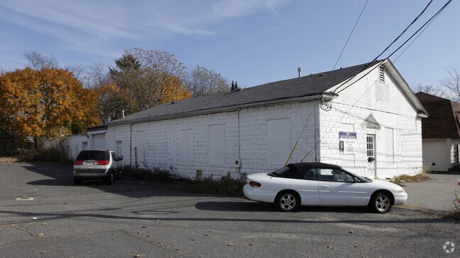
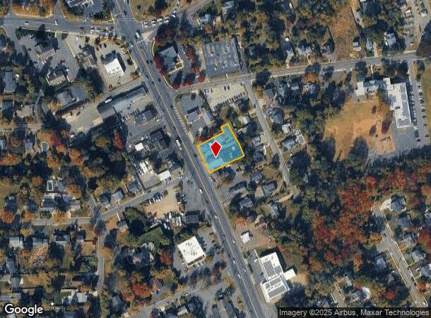
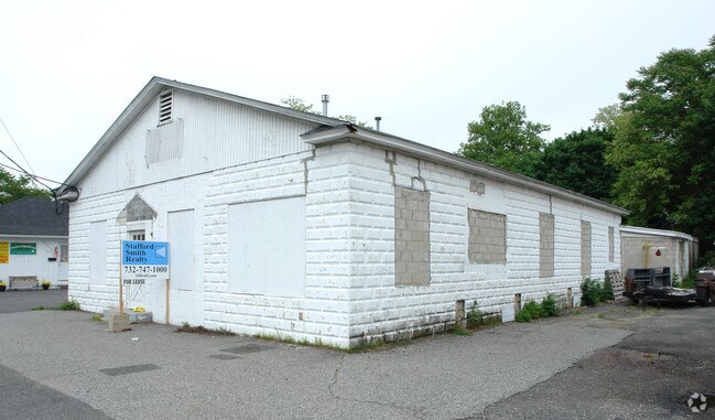
403 Highway 35, Eatontown, NJ 07724
NEARBY LISTINGS FOR SALE OR LEASE
Property Detail
403 Highway 35
32-00962-0000-00005-01
Monmouth
Autorepair
New Jersey
X
5.1
34025C0177F
0.50 AC
2024
Eastern Monmouth
2025
Northern New Jersey
805001
New York-Jersey City-White Plains, NY-NJ
8,660 SF
DEMOGRAPHICS near 403 Highway 35
1 Mile
3 Mile
5 Mile
2024 Total Population
6,808
52,266
126,173
2029 Population
6,720
51,672
125,151
Pop Growth 2024-2029
(1.29%)
(1.14%)
(0.81%)
Average Age
42
42
42
2024 Total Households
2,472
19,704
46,491
HH Growth 2024-2029
(1.54%)
(1.30%)
(0.99%)
Median Household Inc
$133,517
$130,934
$132,746
Avg Household Size
2.70
2.60
2.60
2024 Avg HH Vehicles
2.00
2.00
2.00
Median Home Value
$496,561
$596,303
$589,457
Median Year Built
1966
1964
1967
Nearby Places
Map Layers
Map Styles
 Street
 Aerial
- Restaurants
- Banks
- Shops
- Fitness
- Groceries
PUBLIC TRANSPORTATION
COMMUTER RAIL
Red Bank (North Jersey Coast Line - NJ Transit Commuter Rail (NJ Transit))
DRIVE
WALK
Distance
Red Bank (North Jersey Coast Line - NJ Transit Commuter Rail (NJ Transit))
4 min
1.8 mi
Middletown New Jersey (North Jersey Coast Line - NJ Transit Commuter Rail (NJ Transit))
DRIVE
WALK
Distance
Middletown New Jersey (North Jersey Coast Line - NJ Transit Commuter Rail (NJ Transit))
6 min
2.8 mi
AIRPORT
Newark Liberty International
DRIVE
WALK
Distance
Newark Liberty International
44 min
37.8 mi
Freight Ports
New York Container Terminal
DRIVE
WALK
Distance
New York Container Terminal
1 min
18.8 mi
Nearby Properties
Address
Land Use
TOTAL SIZE
Lot Size
Zoning
Address
Land Use
TOTAL SIZE
Lot Size
Zoning
596.51 AC
FL
Address
Land Use
TOTAL SIZE
Lot Size
Zoning
427,320 SF
5.58 AC
MS
Address
Land Use
TOTAL SIZE
Lot Size
Zoning
199,680 SF
44 SF
MU08
Address
Land Use
TOTAL SIZE
Lot Size
Zoning
14,818 SF
5.27 AC
CCD2
Address
Land Use
TOTAL SIZE
Lot Size
Zoning
1.92 AC
WD
Address
Land Use
TOTAL SIZE
Lot Size
Zoning
251,314 SF
53.63 AC
R-1A
Address
Land Use
TOTAL SIZE
Lot Size
Zoning
231,505 SF
21.75 AC
MU15
Address
Land Use
TOTAL SIZE
Lot Size
Zoning
22.51 AC
RGA
Address
Land Use
TOTAL SIZE
Lot Size
Zoning
118,375 SF
18.20 AC
MU15
Address
Land Use
TOTAL SIZE
Lot Size
Zoning
154,970 SF
1.83 AC
BR-1
Address
Land Use
TOTAL SIZE
Lot Size
Zoning
75,046 SF
6.06 AC
BP
Address
Land Use
TOTAL SIZE
Lot Size
Zoning
840 SF
89.85 AC
B-3
Address
Land Use
TOTAL SIZE
Lot Size
Zoning
241,154 SF
84 AC
R-30
Address
Land Use
TOTAL SIZE
Lot Size
Zoning
12,269 SF
3.60 AC
B-3
Address
Land Use
TOTAL SIZE
Lot Size
Zoning
2,166 SF
77.43 AC
PB
Address
Land Use
TOTAL SIZE
Lot Size
Zoning
97,572 SF
2.57 AC
MU08
Address
Land Use
TOTAL SIZE
Lot Size
Zoning
201,791 SF
10.50 AC
BP
Address
Land Use
TOTAL SIZE
Lot Size
Zoning
237,821 SF
38.92 AC
R-22
Address
Land Use
TOTAL SIZE
Lot Size
Zoning
126,177 SF
14.10 AC
B-3
Address
Land Use
TOTAL SIZE
Lot Size
Zoning
91,564 SF
2.45 AC
BR-1
Address
Land Use
TOTAL SIZE
Lot Size
Zoning
98,400 SF
6 AC
RA
Address
Land Use
TOTAL SIZE
Lot Size
Zoning
127,410 SF
0.01 AC
RHA
Address
Land Use
TOTAL SIZE
Lot Size
Zoning
83.83 AC
BR-1
Address
Land Use
TOTAL SIZE
Lot Size
Zoning
74,870 SF
1.50 AC
MS
Address
Land Use
TOTAL SIZE
Lot Size
Zoning
91,520 SF
21.37 AC
RGA
Address
Land Use
TOTAL SIZE
Lot Size
Zoning
6,910 SF
169.16 AC
R-45
Address
Land Use
TOTAL SIZE
Lot Size
Zoning
5,014 SF
153.81 AC
R-22
Address
Land Use
TOTAL SIZE
Lot Size
Zoning
Address
Land Use
TOTAL SIZE
Lot Size
Zoning
107,553 SF
16 AC
BP
Address
Land Use
TOTAL SIZE
Lot Size
Zoning
107,553 SF
8.70 AC
BP
The World's #1 Commercial Real Estate Marketplace
Connect with us
© 2026 CoStar Group
The information above has been obtained from sources believed reliable. While we do not doubt its accuracy we have not verified it and make no guarantee, warranty or representation about it. It is your responsibility to independently confirm its accuracy and completeness. Any projections, opinions, assumptions, or estimates used are for example only and do not represent the current or future performance of the property. The value of this transaction to you depends on tax and other factors which should be evaluated by your tax, financial, and legal advisors. You and your advisors should conduct a careful, independent investigation of the property to determine to your satisfaction the suitability of the property for your needs.