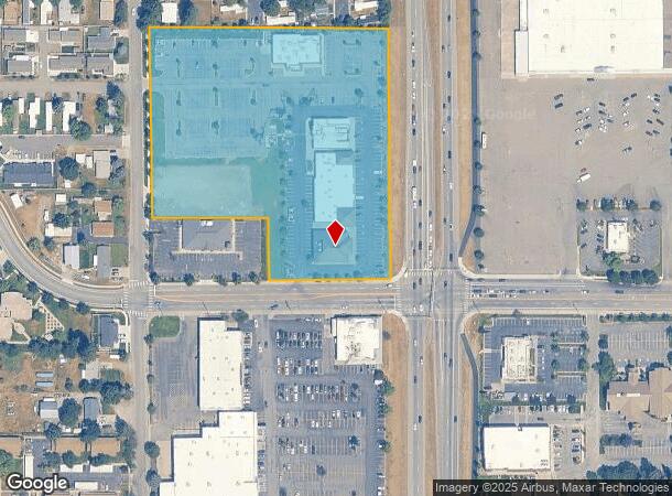
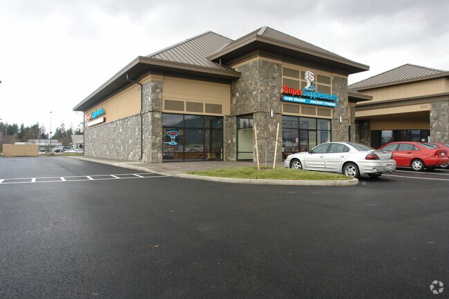
Property Record
403 W Neider Ave, Coeur D Alene, ID 83815

NEARBY LISTINGS FOR SALE OR LEASE
Property Detail
403 W Neider Ave
Coeur d'Alene, ID
Fruit Lands 2Nd Add
CK4580010010
FRUIT LANDS 2ND ADD, LT 1 BLOCK 1 0250N04W
Restaurantbuilding
Kootenai
X
Idaho
16055C0410E
1
2025
6.96 AC
2025
Greater Coeur D'Alene
000901
Other Market Areas
13,364 SF
DEMOGRAPHICS near 403 W Neider Ave
1 Mile
3 Mile
5 Mile
2024 Total Population
8,813
61,664
93,254
2029 Population
10,376
72,817
110,429
Pop Growth 2024-2029
+ 17.74%
+ 18.09%
+ 18.42%
Average Age
41
41
42
2024 Total Households
4,019
25,538
37,778
HH Growth 2024-2029
+ 17.44%
+ 17.77%
+ 18.07%
Median Household Inc
$41,186
$62,221
$64,592
Avg Household Size
2.00
2.30
2.40
2024 Avg HH Vehicles
2.00
2.00
2.00
Median Home Value
$247,469
$425,529
$448,896
Median Year Built
1987
1992
1994
Nearby Places
Map Layers
Map Styles
 Street
 Aerial
- Restaurants
- Banks
- Shops
- Fitness
- Groceries
Nearby Properties
Address
Land Use
TOTAL SIZE
Lot Size
Zoning
Address
Land Use
TOTAL SIZE
Lot Size
Zoning
411,826 SF
15.25 AC
Address
Land Use
TOTAL SIZE
Lot Size
Zoning
278,009 SF
34.55 AC
Address
Land Use
TOTAL SIZE
Lot Size
Zoning
169,000 SF
6.89 AC
Address
Land Use
TOTAL SIZE
Lot Size
Zoning
103,560 SF
17.30 AC
Address
Land Use
TOTAL SIZE
Lot Size
Zoning
103,531 SF
13.75 AC
COM
Address
Land Use
TOTAL SIZE
Lot Size
Zoning
32,132 SF
9.24 AC
Address
Land Use
TOTAL SIZE
Lot Size
Zoning
214,479 SF
36.82 AC
Address
Land Use
TOTAL SIZE
Lot Size
Zoning
231,330 SF
14.55 AC
Address
Land Use
TOTAL SIZE
Lot Size
Zoning
931 SF
16.15 AC
Address
Land Use
TOTAL SIZE
Lot Size
Zoning
138,614 SF
12.25 AC
Address
Land Use
TOTAL SIZE
Lot Size
Zoning
67,668 SF
3.63 AC
Address
Land Use
TOTAL SIZE
Lot Size
Zoning
105,390 SF
6.78 AC
Address
Land Use
TOTAL SIZE
Lot Size
Zoning
230,083 SF
38.41 AC
COM
Address
Land Use
TOTAL SIZE
Lot Size
Zoning
114.08 AC
Address
Land Use
TOTAL SIZE
Lot Size
Zoning
4,569 SF
16.70 AC
Address
Land Use
TOTAL SIZE
Lot Size
Zoning
144,970 SF
11.39 AC
Address
Land Use
TOTAL SIZE
Lot Size
Zoning
4,676 SF
18.37 AC
Address
Land Use
TOTAL SIZE
Lot Size
Zoning
154,743 SF
14.27 AC
Address
Land Use
TOTAL SIZE
Lot Size
Zoning
202,072 SF
6.89 AC
Address
Land Use
TOTAL SIZE
Lot Size
Zoning
43,446 SF
4.91 AC
Address
Land Use
TOTAL SIZE
Lot Size
Zoning
104,752 SF
3.75 AC
Address
Land Use
TOTAL SIZE
Lot Size
Zoning
208,980 SF
18.77 AC
Address
Land Use
TOTAL SIZE
Lot Size
Zoning
116,728 SF
6.48 AC
Address
Land Use
TOTAL SIZE
Lot Size
Zoning
66,856 SF
10.75 AC
Address
Land Use
TOTAL SIZE
Lot Size
Zoning
62,840 SF
8.20 AC
Address
Land Use
TOTAL SIZE
Lot Size
Zoning
167,143 SF
15.32 AC
Address
Land Use
TOTAL SIZE
Lot Size
Zoning
130,535 SF
10.58 AC
Address
Land Use
TOTAL SIZE
Lot Size
Zoning
227,906 SF
16.45 AC
Address
Land Use
TOTAL SIZE
Lot Size
Zoning
47,700 SF
32.44 AC
RESRES
Address
Land Use
TOTAL SIZE
Lot Size
Zoning
33,300 SF
85.77 AC
COM
The World's #1 Commercial Real Estate Marketplace
Connect with us
© 2025 CoStar Group
The information above has been obtained from sources believed reliable. While we do not doubt its accuracy we have not verified it and make no guarantee, warranty or representation about it. It is your responsibility to independently confirm its accuracy and completeness. Any projections, opinions, assumptions, or estimates used are for example only and do not represent the current or future performance of the property. The value of this transaction to you depends on tax and other factors which should be evaluated by your tax, financial, and legal advisors. You and your advisors should conduct a careful, independent investigation of the property to determine to your satisfaction the suitability of the property for your needs.